 Add to Chrome
 Add to Firefox
 Add to Edge
VisBrowse-Bench: Benchmarking Visual-Native Search for Multimodal Browsing Agents
Mar 17, 2026The rapid advancement of Multimodal Large Language Models (MLLMs) has enabled browsing agents to acquire and reason over multimodal information in the real world. But existing benchmarks suffer from two limitations: insufficient evaluation of visual reasoning ability and the neglect of native visual information of web pages in the reasoning chains. To address these challenges, we introduce a new benchmark for visual-native search, VisBrowse-Bench. It contains 169 VQA instances covering multiple domains and evaluates the models' visual reasoning capabilities during the search process through multimodal evidence cross-validation via text-image retrieval and joint reasoning. These data were constructed by human experts using a multi-stage pipeline and underwent rigorous manual verification. We additionally propose an agent workflow that can effectively drive the browsing agent to actively collect and reason over visual information during the search process. We comprehensively evaluated both open-source and closed-source models in this workflow. Experimental results show that even the best-performing model, Claude-4.6-Opus only achieves an accuracy of 47.6%, while the proprietary Deep Research model, o3-deep-research only achieves an accuracy of 41.1%. The code and data can be accessed at: https://github.com/ZhengboZhang/VisBrowse-Bench
DSFC-Net: A Dual-Encoder Spatial and Frequency Co-Awareness Network for Rural Road Extraction
Feb 01, 2026Accurate extraction of rural roads from high-resolution remote sensing imagery is essential for infrastructure planning and sustainable development. However, this task presents unique challenges in rural settings due to several factors. These include high intra-class variability and low inter-class separability from diverse surface materials, frequent vegetation occlusions that disrupt spatial continuity, and narrow road widths that exacerbate detection difficulties. Existing methods, primarily optimized for structured urban environments, often underperform in these scenarios as they overlook such distinctive characteristics. To address these challenges, we propose DSFC-Net, a dual-encoder framework that synergistically fuses spatial and frequency-domain information. Specifically, a CNN branch is employed to capture fine-grained local road boundaries and short-range continuity, while a novel Spatial-Frequency Hybrid Transformer (SFT) is introduced to robustly model global topological dependencies against vegetation occlusions. Distinct from standard attention mechanisms that suffer from frequency bias, the SFT incorporates a Cross-Frequency Interaction Attention (CFIA) module that explicitly decouples high- and low-frequency information via a Laplacian Pyramid strategy. This design enables the dynamic interaction between spatial details and frequency-aware global contexts, effectively preserving the connectivity of narrow roads. Furthermore, a Channel Feature Fusion Module (CFFM) is proposed to bridge the two branches by adaptively recalibrating channel-wise feature responses, seamlessly integrating local textures with global semantics for accurate segmentation. Comprehensive experiments on the WHU-RuR+, DeepGlobe, and Massachusetts datasets validate the superiority of DSFC-Net over state-of-the-art approaches.
A Novel Modeling Framework and Data Product for Extended VIIRS-like Artificial Nighttime Light Image Reconstruction (1986-2024)
Aug 01, 2025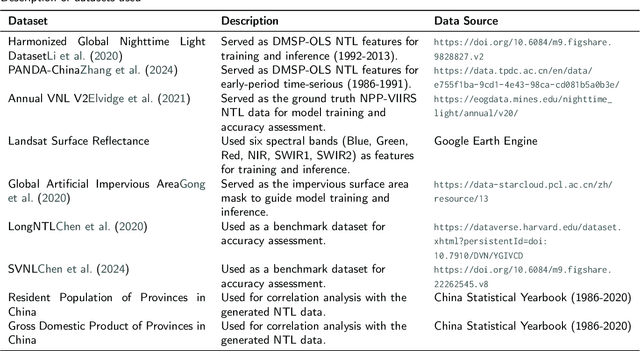
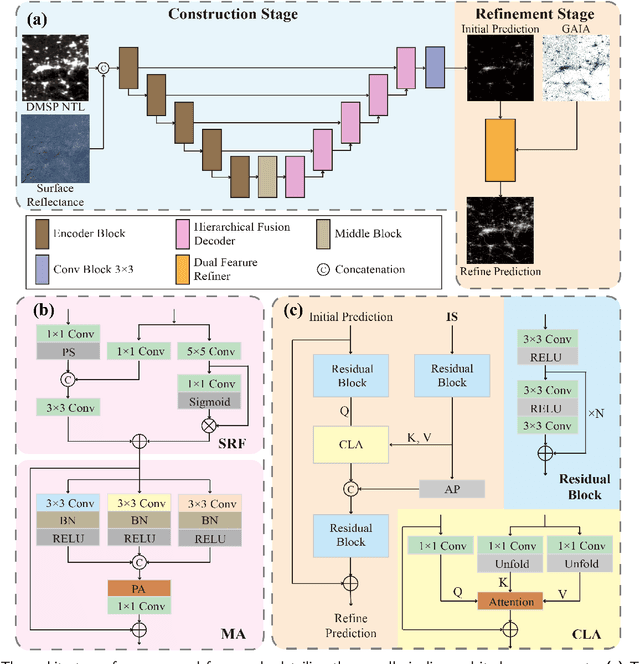
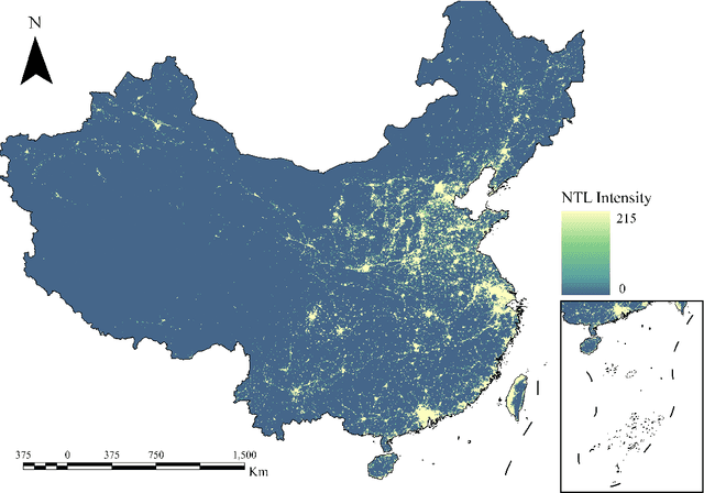
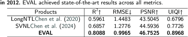
Artificial Night-Time Light (NTL) remote sensing is a vital proxy for quantifying the intensity and spatial distribution of human activities. Although the NPP-VIIRS sensor provides high-quality NTL observations, its temporal coverage, which begins in 2012, restricts long-term time-series studies that extend to earlier periods. Despite the progress in extending VIIRS-like NTL time-series, current methods still suffer from two significant shortcomings: the underestimation of light intensity and the structural omission. To overcome these limitations, we propose a novel reconstruction framework consisting of a two-stage process: construction and refinement. The construction stage features a Hierarchical Fusion Decoder (HFD) designed to enhance the fidelity of the initial reconstruction. The refinement stage employs a Dual Feature Refiner (DFR), which leverages high-resolution impervious surface masks to guide and enhance fine-grained structural details. Based on this framework, we developed the Extended VIIRS-like Artificial Nighttime Light (EVAL) product for China, extending the standard data record backwards by 26 years to begin in 1986. Quantitative evaluation shows that EVAL significantly outperforms existing state-of-the-art products, boosting the $\text{R}^2$ from 0.68 to 0.80 while lowering the RMSE from 1.27 to 0.99. Furthermore, EVAL exhibits excellent temporal consistency and maintains a high correlation with socioeconomic parameters, confirming its reliability for long-term analysis. The resulting EVAL dataset provides a valuable new resource for the research community and is publicly available at https://doi.org/10.11888/HumanNat.tpdc.302930.