 Add to Chrome
 Add to Firefox
 Add to Edge
Shift & Drift: A Zero-Shot Benchmark for Generalizable and Robust Autonomous Driving Motion Planning
Jul 08, 2026
While closed-loop motion planners trained on large-scale, object-level datasets, e.g., nuPlan, demonstrate strong in-distribution (ID) performance, their generalization to novel urban topologies and recovery mechanisms following execution perturbations remain under-explored. To address this, we present Shift & Drift, a novel dual-track benchmark designed to rigorously stress-test motion planners across two critical axes of distribution shift: (1) The Semantic Shift Track leverages a novel conversion pipeline that transforms the aerial, DeepScenario Open 3D dataset into the nuPlan simulation framework. This enables zero-shot evaluation of planners trained on North American and Singaporean data against 1,182 scenarios spanning four German cities and the US city of San Francisco featuring dense pedestrian-cyclist interactions. (2) The State-Distribution Drift Track injects stochastic perturbations into the ego vehicle's dynamics to quantify robustness against compounding execution errors. Based on this, we systematically evaluate the failure modes of diverse planning paradigms under semantic and state-distribution shifts. While imitation learning methods achieve high scores in ID benchmarks, they exhibit significant failures under semantic shift, particularly in pedestrian-dense environments, and suffer from persistent drift when subjected to temporally correlated actuation noise. In contrast, the evaluated reinforcement-learning-based planner demonstrates more graceful degradation, maintaining higher safety and progress metrics across both tracks. Our findings reveal an empirical trade-off between imitation fidelity and closed-loop resilience, providing the community with a rigorous benchmark to evaluate progress toward reliable deployment.

Understanding Cross-Rig Generalization in Automotive Perception: a Multi-Rig Benchmark and Rig Variation Metrics
Jun 25, 2026Camera-based perception systems for autonomous driving are typically developed and evaluated using fixed sensor rigs, while real-world vehicle fleets exhibit substantial variation in camera placement, orientation, field of view, and camera count. This mismatch introduces a cross-rig domain gap in which only the geometric observation process changes. To study this effect under controlled conditions, we introduce Plentiful CARLA Camera Rigs, a benchmark that renders identical driving scenes under 14 systematically designed camera rigs. This setup enables direct analysis of cross-rig generalization without confounding changes in scene content or appearance. Using the benchmark, we analyze cross-rig transfer behavior of representative multi-view perception architectures and observe substantial performance shifts induced by geometric rig variation. To facilitate structured analysis, we further introduce two calibration-based descriptors derived from rig metadata: Rig Variance, capturing internal rig diversity, and Rig Contrastive Distance, measuring geometric discrepancy between rigs. Our experiments show that geometric rig differences strongly correlate with relative cross-rig performance shifts and that Rig Contrastive Distance provides a reliable proxy for ranking transfer difficulty between sensor rigs.
G2DP: Diffusion Planning with Spatio-Temporal Grid Guidance
Jun 25, 2026In autonomous driving, diffusion-based planners have emerged as a promising paradigm for robust motion planning in dense and interactive traffic, as they can effectively model diverse driving behaviors. However, their inherent stochasticity often requires explicit guidance during denoising to ensure safety and route adherence for robust closed-loop execution. Existing guidance typically relies on sparse, entity-centric geometric queries or post-hoc refinement, yielding limited situational awareness and fragile performance in interactive scenes. To address this issue, we propose G2DP (Grid-Guided Diffusion Planning), a diffusion-based planner that directly enforces dense environmental constraints through inference-time guidance. Specifically, G2DP constructs a differentiable spatio-temporal cost volume by fusing probabilistic future occupancy distributions with a route-progress map. By formulating this volume as a continuous safety energy functional, it injects dense gradients directly into the denoising loop, actively steering trajectory generation toward collision-free and progress-optimal regions. Extensive closed-loop evaluations show that G2DP achieves state-of-the-art performance on nuPlan, outperforming the strongest imitation-learning baseline by +7.2 points in reactive score. It further maintains top scores in zero-shot transfers to interPlan and DeepScenario benchmarks, with collision avoidance improving by +10.15 over the unguided approach on interPlan. These results demonstrate that spatio-temporal cost grids serve as an effective representation for robust guidance in diffusion-based planning.
HYPE: Hybrid Planning with Ego Proposal-Conditioned Predictions
Oct 14, 2025Safe and interpretable motion planning in complex urban environments needs to reason about bidirectional multi-agent interactions. This reasoning requires to estimate the costs of potential ego driving maneuvers. Many existing planners generate initial trajectories with sampling-based methods and refine them by optimizing on learned predictions of future environment states, which requires a cost function that encodes the desired vehicle behavior. Designing such a cost function can be very challenging, especially if a wide range of complex urban scenarios has to be considered. We propose HYPE: HYbrid Planning with Ego proposal-conditioned predictions, a planner that integrates multimodal trajectory proposals from a learned proposal model as heuristic priors into a Monte Carlo Tree Search (MCTS) refinement. To model bidirectional interactions, we introduce an ego-conditioned occupancy prediction model, enabling consistent, scene-aware reasoning. Our design significantly simplifies cost function design in refinement by considering proposal-driven guidance, requiring only minimalistic grid-based cost terms. Evaluations on large-scale real-world benchmarks nuPlan and DeepUrban show that HYPE effectively achieves state-of-the-art performance, especially in safety and adaptability.
CNN-based Lidar Point Cloud De-Noising in Adverse Weather
Dec 09, 2019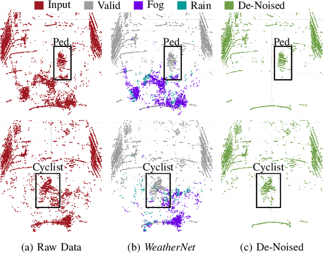
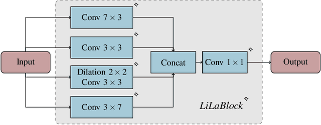

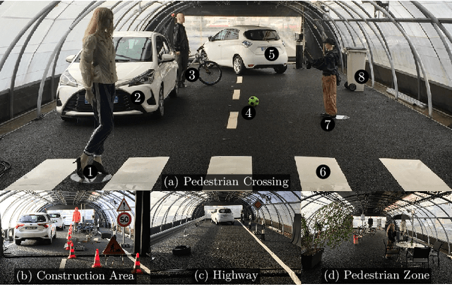
Lidar sensors are frequently used in environment perception for autonomous vehicles and mobile robotics to complement camera, radar, and ultrasonic sensors. Adverse weather conditions are significantly impacting the performance of lidar-based scene understanding by causing undesired measurement points that in turn effect missing detections and false positives. In heavy rain or dense fog, water drops could be misinterpreted as objects in front of the vehicle which brings a mobile robot to a full stop. In this paper, we present the first CNN-based approach to understand and filter out such adverse weather effects in point cloud data. Using a large data set obtained in controlled weather environments, we demonstrate a significant performance improvement of our method over state-of-the-art involving geometric filtering. Data is available at https://github.com/rheinzler/PointCloudDeNoising.
Weather Influence and Classification with Automotive Lidar Sensors
Jun 18, 2019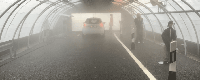
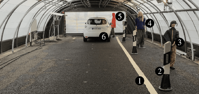
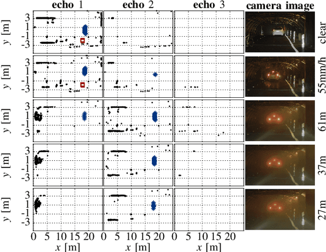
Lidar sensors are often used in mobile robots and autonomous vehicles to complement camera, radar and ultrasonic sensors for environment perception. Typically, perception algorithms are trained to only detect moving and static objects as well as ground estimation, but intentionally ignore weather effects to reduce false detections. In this work, we present an in-depth analysis of automotive lidar performance under harsh weather conditions, i.e. heavy rain and dense fog. An extensive data set has been recorded for various fog and rain conditions, which is the basis for the conducted in-depth analysis of the point cloud under changing environmental conditions. In addition, we introduce a novel approach to detect and classify rain or fog with lidar sensors only and achieve an mean union over intersection of 97.14 % for a data set in controlled environments. The analysis of weather influences on the performance of lidar sensors and the weather detection are important steps towards improving safety levels for autonomous driving in adverse weather conditions by providing reliable information to adapt vehicle behavior.