 Add to Chrome
 Add to Firefox
 Add to Edge
Search over the Visual World: Persistent Visual Memory, Layered Indexes, and Source-Grounded Evidence
Aug 08, 2026
Most video-retrieval systems assume a bounded corpus and return ranked files or timestamps. Agents operating over cameras, screens, streams, and archives face a different systems problem: observations arrive continuously; models interpret them at different temporal granularities; context must be selected without replaying the complete visual record; and results must stay connected to inspectable source evidence. We argue that search over such a corpus is an infrastructure problem that cannot be reduced to ranking video files. We develop a conceptual and formal model of search over the visual world built on analyzer-defined scenes, persistent understanding artifacts, visual memory as coexisting scene spaces over shared source time, and capability-declared indexes, distinguishing memory (everything retained), context (what is selected for a task), and evidence (the source intervals that ground it). The VideoDB data format (VDB) realizes this model in production, exposed through a typed search surface spanning planned retrieval, stateful investigation, direct access, and grounded synthesis. We contrast this model-agnostic infrastructure, where segmentation, sampling, model choice, embeddings, and ranking are system decisions and live streams are first-class sources, with video-native foundation models offered as fixed APIs. In a semantic-retrieval comparison against a commercial video-native engine spanning 9,800+ queries over four public datasets, a pipeline of general-purpose components achieves higher macro-averaged Recall@1/@3/@10 (73.09/83.39/91.20 versus 65.75/77.13/89.10), while the baseline is higher at Recall@50 (96.42 versus 96.07). Retrieval quality over the visual world is today governed more by system design than by video-specific pretraining, and visual-memory infrastructure can deliver it while keeping playable, source-grounded evidence first-class.

VDB-EDT: An Efficient Euclidean Distance Transform Algorithm Based on VDB Data Structure
May 10, 2021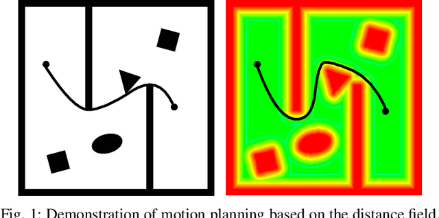
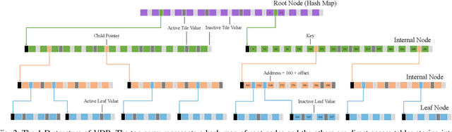
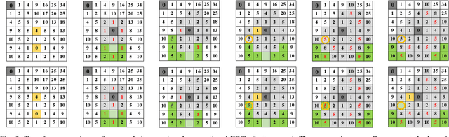
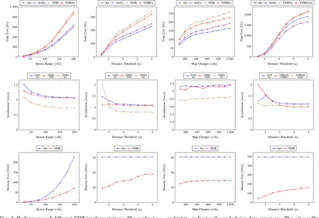
This paper presents a fundamental algorithm, called VDB-EDT, for Euclidean distance transform (EDT) based on the VDB data structure. The algorithm executes on grid maps and generates the corresponding distance field for recording distance information against obstacles, which forms the basis of numerous motion planning algorithms. The contributions of this work mainly lie in three folds. Firstly, we propose a novel algorithm that can facilitate distance transform procedures by optimizing the scheduling priorities of transform functions, which significantly improves the running speed of conventional EDT algorithms. Secondly, we for the first time introduce the memory-efficient VDB data structure, a customed B+ tree, to represent the distance field hierarchically. Benefiting from the special index and caching mechanism, VDB shows a fast (average \textit{O}(1)) random access speed, and thus is very suitable for the frequent neighbor-searching operations in EDT. Moreover, regarding the small scale of existing datasets, we release a large-scale dataset captured from subterranean environments to benchmark EDT algorithms. Extensive experiments on the released dataset and publicly available datasets show that VDB-EDT can reduce memory consumption by about 30%-85%, depending on the sparsity of the environment, while maintaining a competitive running speed with the fastest array-based implementation. The experiments also show that VDB-EDT can significantly outperform the state-of-the-art EDT algorithm in both runtime and memory efficiency, which strongly demonstrates the advantages of our proposed method. The released dataset and source code are available on https://github.com/zhudelong/VDB-EDT.
Visual Servoing Approach for Autonomous UAV Landing on a Moving Vehicle
Apr 02, 2021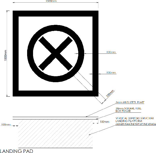
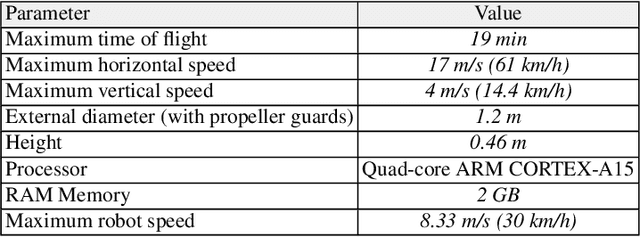
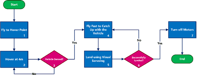
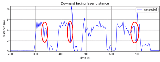
We present a method to autonomously land an Unmanned Aerial Vehicle on a moving vehicle with a circular (or elliptical) pattern on the top. A visual servoing controller approaches the ground vehicle using velocity commands calculated directly in image space. The control laws generate velocity commands in all three dimensions, eliminating the need for a separate height controller. The method has shown the ability to approach and land on the moving deck in simulation, indoor and outdoor environments, and compared to the other available methods, it has provided the fastest landing approach. It does not rely on additional external setup, such as RTK, motion capture system, ground station, offboard processing, or communication with the vehicle, and it requires only a minimal set of hardware and localization sensors. The videos and source codes can be accessed from http://theairlab.org/landing-on-vehicle.
Monocular and Stereo Cues for Landing Zone Evaluation for Micro UAVs
Dec 09, 2018
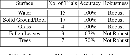
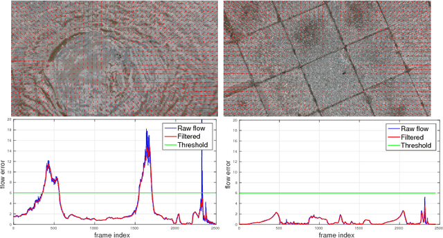
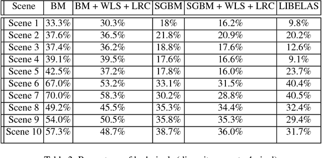
Autonomous and safe landing is important for unmanned aerial vehicles. We present a monocular and stereo image based method for fast and accurate landing zone evaluation for UAVs in various scenarios. Many existing methods rely on Lidar or depth sensor to provide accurate and dense surface reconstruction. We utilize stereo images to evaluate the slope and monocular images to compute homography error. By combining them together, our approach works for both rigid and non-rigid dynamic surfaces. Experiments on many outdoor scenes such as water, grass and roofs, demonstrate the robustness and effectiveness of our approach.