 Add to Chrome
 Add to Firefox
 Add to Edge
Reconstructing Global Daily CO2 Emissions via Machine Learning
Jul 29, 2024


High temporal resolution CO2 emission data are crucial for understanding the drivers of emission changes, however, current emission dataset is only available on a yearly basis. Here, we extended a global daily CO2 emissions dataset backwards in time to 1970 using machine learning algorithm, which was trained to predict historical daily emissions on national scales based on relationships between daily emission variations and predictors established for the period since 2019. Variation in daily CO2 emissions far exceeded the smoothed seasonal variations. For example, the range of daily CO2 emissions equivalent to 31% of the year average daily emissions in China and 46% of that in India in 2022, respectively. We identified the critical emission-climate temperature (Tc) is 16.5 degree celsius for global average (18.7 degree celsius for China, 14.9 degree celsius for U.S., and 18.4 degree celsius for Japan), in which negative correlation observed between daily CO2 emission and ambient temperature below Tc and a positive correlation above it, demonstrating increased emissions associated with higher ambient temperature. The long-term time series spanning over fifty years of global daily CO2 emissions reveals an increasing trend in emissions due to extreme temperature events, driven by the rising frequency of these occurrences. This work suggests that, due to climate change, greater efforts may be needed to reduce CO2 emissions.
METER-ML: A Multi-sensor Earth Observation Benchmark for Automated Methane Source Mapping
Jul 22, 2022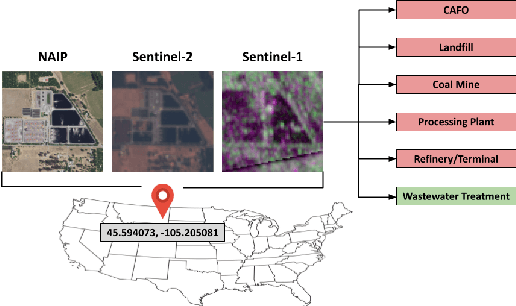
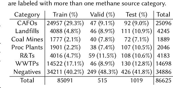
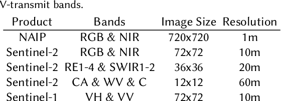
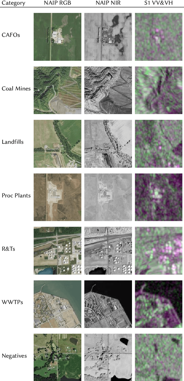
Reducing methane emissions is essential for mitigating global warming. To attribute methane emissions to their sources, a comprehensive dataset of methane source infrastructure is necessary. Recent advancements with deep learning on remotely sensed imagery have the potential to identify the locations and characteristics of methane sources, but there is a substantial lack of publicly available data to enable machine learning researchers and practitioners to build automated mapping approaches. To help fill this gap, we construct a multi-sensor dataset called METER-ML containing 86,625 georeferenced NAIP, Sentinel-1, and Sentinel-2 images in the U.S. labeled for the presence or absence of methane source facilities including concentrated animal feeding operations, coal mines, landfills, natural gas processing plants, oil refineries and petroleum terminals, and wastewater treatment plants. We experiment with a variety of models that leverage different spatial resolutions, spatial footprints, image products, and spectral bands. We find that our best model achieves an area under the precision recall curve of 0.915 for identifying concentrated animal feeding operations and 0.821 for oil refineries and petroleum terminals on an expert-labeled test set, suggesting the potential for large-scale mapping. We make METER-ML freely available at https://stanfordmlgroup.github.io/projects/meter-ml/ to support future work on automated methane source mapping.
OGNet: Towards a Global Oil and Gas Infrastructure Database using Deep Learning on Remotely Sensed Imagery
Nov 14, 2020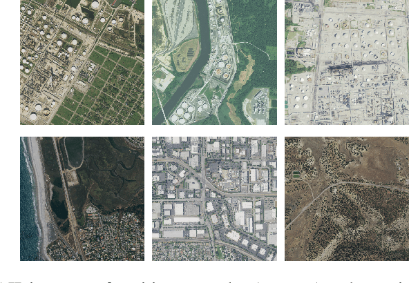
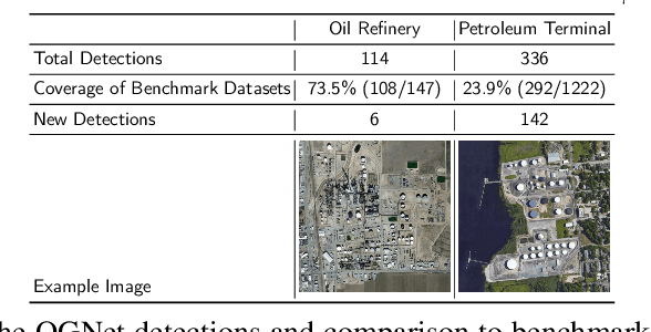
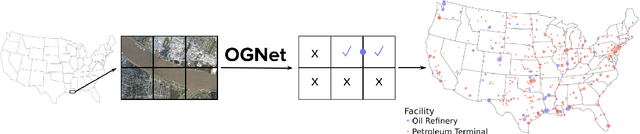
At least a quarter of the warming that the Earth is experiencing today is due to anthropogenic methane emissions. There are multiple satellites in orbit and planned for launch in the next few years which can detect and quantify these emissions; however, to attribute methane emissions to their sources on the ground, a comprehensive database of the locations and characteristics of emission sources worldwide is essential. In this work, we develop deep learning algorithms that leverage freely available high-resolution aerial imagery to automatically detect oil and gas infrastructure, one of the largest contributors to global methane emissions. We use the best algorithm, which we call OGNet, together with expert review to identify the locations of oil refineries and petroleum terminals in the U.S. We show that OGNet detects many facilities which are not present in four standard public datasets of oil and gas infrastructure. All detected facilities are associated with characteristics known to contribute to methane emissions, including the infrastructure type and the number of storage tanks. The data curated and produced in this study is freely available at http://stanfordmlgroup.github.io/projects/ognet .