 Add to Chrome
 Add to Firefox
 Add to Edge
Creating Impactful Autonomous Driving Datasets: A Strategic Guide from Research Gap to Benchmark
Jul 01, 2026
Well-designed autonomous driving datasets have fundamentally shaped research progress, yet existing literature primarily describes what datasets contain rather than how to strategically design impactful ones. This is especially limiting for small and medium-sized labs and startups that cannot afford to misallocate scarce resources. We argue that impactful dataset creation begins with a diagnosis: whether a research question is blocked by a data problem or an evaluation problem, and proceeds by selecting the minimal data operator(s) that closes the resulting gap, recording new data only when no cheaper operator(s) suffices. We analyze the evolution of major autonomous driving (AD) datasets through this lens and distill a strategic framework spanning gap identification, operator choice, sensor suite design, and annotation strategy. We ground the framework in a running case study of our KITScenes dataset family. The datasets are available at: https://kitscenes.com/

The Road Ahead in Autonomous Driving: The KITScenes Multimodal Dataset
Jun 01, 2026Existing autonomous driving datasets have enabled major progress, but fall short in sensor fidelity, map completeness, or geographic diversity. We present KITScenes Multimodal, a European dataset built around high-fidelity sensors and maps. Our fully synchronized sensor suite combines high-resolution global-shutter cameras, long-range lidar beyond 400m, 4D imaging radar, and redundant GNSS/INS localization. Our HD maps are, to our knowledge, the most complete of any sensor dataset, validated through autonomous driving trials on open-source software. For the first time in a public dataset, all driving-relevant traffic elements, such as traffic lights, are mapped in 3D to a reprojection-accurate level with full topological connectivity. Recorded in cities with irregular street layouts and mixed traffic modes, our dataset complements existing datasets by broadening the available geographic diversity. We also introduce four benchmarks, each advancing spatial learning for embodied AI: online HD map construction, long-range depth estimation, novel view synthesis, and end-to-end driving. Project page: https://kitscenes.com/
LongTail Driving Scenarios with Reasoning Traces: The KITScenes LongTail Dataset
Mar 24, 2026In real-world domains such as self-driving, generalization to rare scenarios remains a fundamental challenge. To address this, we introduce a new dataset designed for end-to-end driving that focuses on long-tail driving events. We provide multi-view video data, trajectories, high-level instructions, and detailed reasoning traces, facilitating in-context learning and few-shot generalization. The resulting benchmark for multimodal models, such as VLMs and VLAs, goes beyond safety and comfort metrics by evaluating instruction following and semantic coherence between model outputs. The multilingual reasoning traces in English, Spanish, and Chinese are from domain experts with diverse cultural backgrounds. Thus, our dataset is a unique resource for studying how different forms of reasoning affect driving competence. Our dataset is available at: https://hf.co/datasets/kit-mrt/kitscenes-longtail
NaviTrace: Evaluating Embodied Navigation of Vision-Language Models
Oct 30, 2025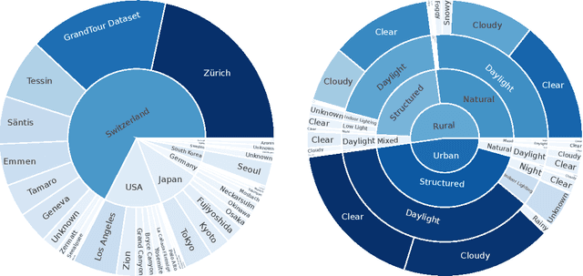
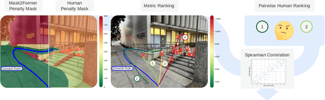
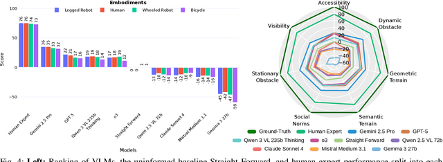
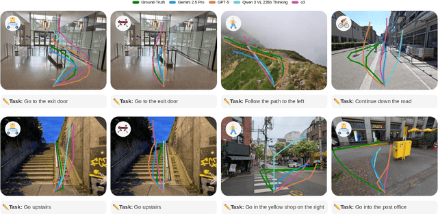
Vision-language models demonstrate unprecedented performance and generalization across a wide range of tasks and scenarios. Integrating these foundation models into robotic navigation systems opens pathways toward building general-purpose robots. Yet, evaluating these models' navigation capabilities remains constrained by costly real-world trials, overly simplified simulations, and limited benchmarks. We introduce NaviTrace, a high-quality Visual Question Answering benchmark where a model receives an instruction and embodiment type (human, legged robot, wheeled robot, bicycle) and must output a 2D navigation trace in image space. Across 1000 scenarios and more than 3000 expert traces, we systematically evaluate eight state-of-the-art VLMs using a newly introduced semantic-aware trace score. This metric combines Dynamic Time Warping distance, goal endpoint error, and embodiment-conditioned penalties derived from per-pixel semantics and correlates with human preferences. Our evaluation reveals consistent gap to human performance caused by poor spatial grounding and goal localization. NaviTrace establishes a scalable and reproducible benchmark for real-world robotic navigation. The benchmark and leaderboard can be found at https://leggedrobotics.github.io/navitrace_webpage/.