 Add to Chrome
 Add to Firefox
 Add to Edge
WNOJ-LIO: A White-Noise-on-Jerk Motion-Prior EKF for High-Dynamic LiDAR-IMU Fusion
Jul 15, 2026
LiDAR-inertial odometry (LIO) is a key component of autonomous navigation, but high-dynamic driving exposes two coupled challenges: intra-scan motion distortion and vibration-contaminated inertial measurements. Most real-time LiDAR-inertial pipelines propagate the system state by integrating raw IMU measurements and then use the propagated trajectory for point cloud de-distortion, thereby propagating inertial noise into both the corrected scan and the subsequent scan-to-map registration. This paper presents WNOJ-LIO, a LiDAR-IMU fusion framework based on a White-Noise-on-Jerk (WNOJ) Extended Kalman Filter (EKF). WNOJ-LIO employs a decoupled WNOJ prior on $\R^3 \times \SO(3)$ for state prediction and treats the IMU as a high-frequency measurement source rather than the driver of state propagation. The resulting posterior state history is then used for LiDAR scan de-distortion and subsequent point-to-plane LiDAR updates. The decoupled process model enables closed-form covariance propagation, thereby bridging the gap between batch WNOJ Gaussian process (GP) trajectory priors and recursive filtering. Simulation results demonstrate improvements in acceleration and angular-velocity denoising, scan de-distortion, and localization accuracy over a FAST-LIO-style baseline. Real-world experiments were conducted using an autonomous racing car on four driving segments with maximum speeds ranging from 53 to 208~km/h, covering a wide range of vehicle vibration levels. The experiments further validate the proposed method and provide a comprehensive evaluation of its performance in estimating acceleration, angular velocity, body-frame linear velocity, attitude, and position under highly dynamic driving. The source code of WNOJ-LIO is publicly available at https://github.com/LvJohny/wnoj-ekf-lio.git.

AUSLUN: A Fixed-Hover UAV--USV System for GNSS-Denied Maritime Search and Navigation
Jun 29, 2026Global navigation satellite system (GNSS) denial can prevent an unmanned surface vehicle (USV) from both finding a distant vessel and maintaining a globally referenced approach. This paper presents AUSLUN (Automatic UAV Search, Localization, and USV Navigation), a fixed-hover aerial-surface system that uses a coastal unmanned aerial vehicle (UAV), which estimates its own pose through visual-inertial odometry (VIO), as a long-range sensing and navigation anchor. The central design shifts sensing motion from UAV translation to a zoom pod and closes the loop through three coupled elements: polygon-aware annular pod scanning, modality-aware bearing-range localization, and target-relative USV guidance with visual-loss recovery. The same gated recursive estimator uses laser range for the non-cooperative target and datalink range for the cooperative USV. Search-planning simulations show that the adaptive yaw bounds reduce scan time and redundant coverage relative to a matched fixed-sector scan, and GPS-referenced field data show that the gated recursive estimator outperforms non-recursive baselines in localization accuracy. An integrated maritime mission further demonstrates the complete search-to-navigation sequence, including a deliberately triggered visual-loss recovery. These results establish the feasibility and operating boundary of fixed-hover UAV assistance for stationary-target approach in coastal GNSS-denied environments. The source code and a video demonstration are publicly available at https://github.com/xirhxq/pod_search and https://youtu.be/S-5RkJs35JI.
Incorporating Domain Knowledge through Task Augmentation for Front-End JavaScript Code Generation
Aug 23, 2022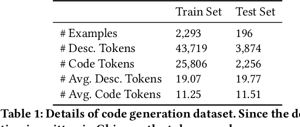
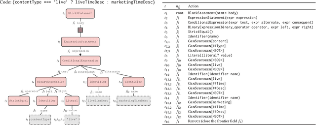


Code generation aims to generate a code snippet automatically from natural language descriptions. Generally, the mainstream code generation methods rely on a large amount of paired training data, including both the natural language description and the code. However, in some domain-specific scenarios, building such a large paired corpus for code generation is difficult because there is no directly available pairing data, and a lot of effort is required to manually write the code descriptions to construct a high-quality training dataset. Due to the limited training data, the generation model cannot be well trained and is likely to be overfitting, making the model's performance unsatisfactory for real-world use. To this end, in this paper, we propose a task augmentation method that incorporates domain knowledge into code generation models through auxiliary tasks and a Subtoken-TranX model by extending the original TranX model to support subtoken-level code generation. To verify our proposed approach, we collect a real-world code generation dataset and conduct experiments on it. Our experimental results demonstrate that the subtoken-level TranX model outperforms the original TranX model and the Transformer model on our dataset, and the exact match accuracy of Subtoken-TranX improves significantly by 12.75% with the help of our task augmentation method. The model performance on several code categories has satisfied the requirements for application in industrial systems. Our proposed approach has been adopted by Alibaba's BizCook platform. To the best of our knowledge, this is the first domain code generation system adopted in industrial development environments.
FAST-LIVO: Fast and Tightly-coupled Sparse-Direct LiDAR-Inertial-Visual Odometry
Mar 02, 2022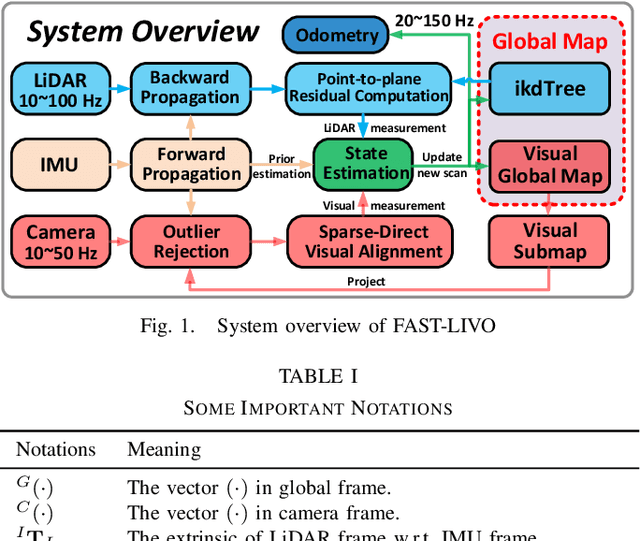
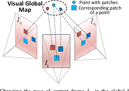
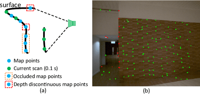
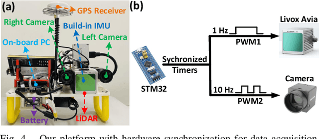
To achieve accurate and robust pose estimation in Simultaneous Localization and Mapping (SLAM) task, multi-sensor fusion is proven to be an effective solution and thus provides great potential in robotic applications. This paper proposes FAST-LIVO, a fast LiDAR-Inertial-Visual Odometry system, which builds on two tightly-coupled and direct odometry subsystems: a VIO subsystem and a LIO subsystem. The LIO subsystem registers raw points (instead of feature points on e.g., edges or planes) of a new scan to an incrementally-built point cloud map. The map points are additionally attached with image patches, which are then used in the VIO subsystem to align a new image by minimizing the direct photometric errors without extracting any visual features (e.g., ORB or FAST corner features). To further improve the VIO robustness and accuracy, a novel outlier rejection method is proposed to reject unstable map points that lie on edges or are occluded in the image view. Experiments on both open data sequences and our customized device data are conducted. The results show our proposed system outperforms other counterparts and can handle challenging environments at reduced computation cost. The system supports both multi-line spinning LiDARs and emerging solid-state LiDARs with completely different scanning patterns, and can run in real-time on both Intel and ARM processors. We open source our code and dataset of this work on Github to benefit the robotics community.