 Add to Chrome
 Add to Firefox
 Add to Edge
Localization in Spatiotemporal Fields via Environmental PDEs
Jul 31, 2026
This paper proposes a localization framework that uses spatiotemporal fields governed by partial differential equations (PDEs) as localization signatures. Two PDE classes are considered: the shallow water equations, which describe free-surface flows in coastal and riverine environments, and the advection-diffusion equation, which models the transport and mixing of scalar quantities such as temperature, salinity, and dissolved oxygen. A numerical PDE solver provides predicted fields over the domain, and multiple field channels are fused as multimodal measurements to improve localization accuracy. We formulate the problem within a Rao-Blackwellized particle filter (RBPF) that partitions the vehicle state into a nonlinear component sampled by particles and a linear sensor bias component tracked analytically via per-particle Kalman filters. This factorization reduces the required number of particles compared to a standard particle filter while accounting for realistic sensor drift. Simulation studies on both PDE scenarios show that the RBPF consistently outperforms a standard particle filter in terms of final position error and Root Mean Square Error (RMSE) across varying particle counts. Field experiments with an autonomous surface vehicle measuring salinity, temperature, and dissolved oxygen validate that PDE-governed environmental fields provide sufficient spatial variability for practical localization. Related experimental videos are available at https://localization-environmental-pdes.github.io/.

A New Implementation of NeoSLAM and a Comparative Evaluation with RatSLAM
Jul 17, 2026This paper presents a new implementation of the NeoSLAM algorithm. The proposed version is a complete rewrite of NeoSLAM into a modular architecture using modern frameworks that, together, enable real-time execution with minimal discarding of input data. This work also provides a comparative evaluation between NeoSLAM and RatSLAM across three datasets under varying environmental conditions. The experimental results highlight differences in mapping consistency and trajectory reconstruction, demonstrating the effectiveness and practical applicability of the proposed ROS2-based implementation. The results indicate that the new NeoSLAM outperforms the original in terms of processing throughput for real-time applications and achieves comparable performance to RatSLAM in terms of map reconstruction across the evaluated datasets.
BOWConnect: Parallel Bayesian Optimization over Windows with Learned Local Cost Maps for Sample-Efficient Kinodynamic Motion Planning
Jun 25, 2026This paper presents BOWConnect, a bidirectional parallel kinodynamic motion planner that addresses three fundamental limitations of existing sampling-based methods: sample inefficiency in high-dimensional state spaces, unreliable cost heuristics under dynamic constraints, and poor performance in narrow passage environments. Unlike classical planners that rely on random control sampling and geometric distance heuristics, BOWConnect integrates Bayesian Optimization over Windows (BOW) as a learning-based steering function within a parallel tree-based exploration framework, enabling each worker to learn local cost maps and constraints to guide sampling toward dynamically feasible and collision-free controls. A bidirectional architecture simultaneously grows forward and backward trees from the start and goal regions in parallel threads, with a spatial hashing mechanism enabling fast connection queries and a boundary value problem solver generating kinodynamically consistent bridge trajectories. Extensive evaluations across ten benchmark environments demonstrate that BOWConnect achieves 100\% success while delivering the fastest or near-fastest planning time in complex scenarios, including narrow passages and non-convex spaces where state-of-the-art planners fail or degrade substantially. Real-world deployment on a ground vehicle and a quadrotor confirms real-time planning with no collisions. Videos of real-world and simulated experiments, high-resolution versions of the figures, and the open-source code are available at https://bow-connect.github.io/.
Muninn: Your Trajectory Diffusion Model But Faster
May 11, 2026Diffusion-based trajectory planners can synthesize rich, multimodal robot motions, but their iterative denoising makes online planning and control prohibitively slow. Existing accelerations either modify the sampler or compress the network--sacrificing plan quality or requiring retraining without accounting for downstream control risk. We address the problem of making diffusion-based trajectory planners fast enough for real-time robot use without retraining the model or sacrificing trajectory quality, and in a way that works across diverse state-space diffusion architectures. Our key insight is that diffusion trajectory planners expose two signals we can exploit: a cheap probe of how their internal trajectory representation changes across steps, and analytic coefficients that describe how denoiser errors affect the sampler's state update. By calibrating the first signal against the second on offline runs, we obtain a per-step score that upper-bounds how far the final trajectory can deviate when we reuse a cached denoiser output, and we treat this bound as an uncertainty budget that we can spend over the denoising process. Building on this insight, we present Muninn, a training-free caching wrapper that tracks this uncertainty budget during sampling and, at each diffusion step, chooses between reusing a cached denoiser output when the predicted deviation is small and recomputing the denoiser when it is not. Across standard benchmarks Muninn delivers up to 4.6x wall-clock speedups across several trajectory diffusion models by reducing denoiser evaluations, while preserving task performance and safety metrics. Muninn further certifies that cached rollouts remain within a specified distance of their full-compute counterparts, and we validate these gains in real-time closed-loop navigation and manipulation hardware deployments. Project page: https://github.com/gokulp01/Muninn.
Energy-Efficient Multi-Robot Coverage Path Planning of Non-Convex Regions of Interests
Apr 24, 2026This letter presents an energy-efficient multi-robot coverage path planning (MRCPP) framework for large, nonconvex Regions of Interest (ROI) containing obstacles and no-fly zones (NFZ). Existing minimum-energy coverage planning algorithms utilize meta-heuristic boustrophedon workspace decomposition. Therefore, even with minimum energy objectives and energy consumption constraints, they cannot achieve optimal energy efficiency. Moreover, most existing frameworks support only a single type of robotic platform. MRCPP overcomes these limitations by: generating globally-informed swath generation, creating parallel sweeping paths with minimal turns, calculating safety buffers to ensure safe turning clearance, using an efficient mTSP solver to balance workloads and minimize mission time, and connecting disjoint segments via a modified visibility graph that tracks heading angles while maintaining transitions within safe regions. The efficacy of the proposed MRCPP framework is demonstrated through real-world experiments involving autonomous aerial vehicles (AAVs) and autonomous surface vehicles (ASVs). Evaluations demonstrate that the proposed MRCPP consistently outperforms state-of-the-art planners, reducing average total energy consumption by 3\% to 40\% for a team of 3 robots and computation time by an order of magnitude, while maintaining balanced workload distribution and strong scalability across increasing fleet sizes. The MRCPP framework is released as an open-source package and videos of real-world and simulated experiments are available at https://mrc-pp.github.io.
Online Learning of Deceptive Policies under Intermittent Observation
Sep 19, 2025In supervisory control settings, autonomous systems are not monitored continuously. Instead, monitoring often occurs at sporadic intervals within known bounds. We study the problem of deception, where an agent pursues a private objective while remaining plausibly compliant with a supervisor's reference policy when observations occur. Motivated by the behavior of real, human supervisors, we situate the problem within Theory of Mind: the representation of what an observer believes and expects to see. We show that Theory of Mind can be repurposed to steer online reinforcement learning (RL) toward such deceptive behavior. We model the supervisor's expectations and distill from them a single, calibrated scalar -- the expected evidence of deviation if an observation were to happen now. This scalar combines how unlike the reference and current action distributions appear, with the agent's belief that an observation is imminent. Injected as a state-dependent weight into a KL-regularized policy improvement step within an online RL loop, this scalar informs a closed-form update that smoothly trades off self-interest and compliance, thus sidestepping hand-crafted or heuristic policies. In real-world, real-time hardware experiments on marine (ASV) and aerial (UAV) navigation, our ToM-guided RL runs online, achieves high return and success with observed-trace evidence calibrated to the supervisor's expectations.
Deep Learning and Foundation Models for Weather Prediction: A Survey
Jan 12, 2025Physics-based numerical models have been the bedrock of atmospheric sciences for decades, offering robust solutions but often at the cost of significant computational resources. Deep learning (DL) models have emerged as powerful tools in meteorology, capable of analyzing complex weather and climate data by learning intricate dependencies and providing rapid predictions once trained. While these models demonstrate promising performance in weather prediction, often surpassing traditional physics-based methods, they still face critical challenges. This paper presents a comprehensive survey of recent deep learning and foundation models for weather prediction. We propose a taxonomy to classify existing models based on their training paradigms: deterministic predictive learning, probabilistic generative learning, and pre-training and fine-tuning. For each paradigm, we delve into the underlying model architectures, address major challenges, offer key insights, and propose targeted directions for future research. Furthermore, we explore real-world applications of these methods and provide a curated summary of open-source code repositories and widely used datasets, aiming to bridge research advancements with practical implementations while fostering open and trustworthy scientific practices in adopting cutting-edge artificial intelligence for weather prediction. The related sources are available at https://github.com/JimengShi/ DL-Foundation-Models-Weather.
Enhancing Robot Navigation Policies with Task-Specific Uncertainty Management
Oct 19, 2024


Robots performing navigation tasks in complex environments face significant challenges due to uncertainty in state estimation. Effectively managing this uncertainty is crucial, but the optimal approach varies depending on the specific details of the task: different tasks require varying levels of precision in different regions of the environment. For instance, a robot navigating a crowded space might need precise localization near obstacles but can operate effectively with less precise state estimates in open areas. This varying need for certainty in different parts of the environment, depending on the task, calls for policies that can adapt their uncertainty management strategies based on task-specific requirements. In this paper, we present a framework for integrating task-specific uncertainty requirements directly into navigation policies. We introduce Task-Specific Uncertainty Map (TSUM), which represents acceptable levels of state estimation uncertainty across different regions of the operating environment for a given task. Using TSUM, we propose Generalized Uncertainty Integration for Decision-Making and Execution (GUIDE), a policy conditioning framework that incorporates these uncertainty requirements into the robot's decision-making process. We find that conditioning policies on TSUMs provides an effective way to express task-specific uncertainty requirements and enables the robot to reason about the context-dependent value of certainty. We show how integrating GUIDE into reinforcement learning frameworks allows the agent to learn navigation policies without the need for explicit reward engineering to balance task completion and uncertainty management. We evaluate GUIDE on a variety of real-world navigation tasks and find that it demonstrates significant improvements in task completion rates compared to baselines. Evaluation videos can be found at https://guided-agents.github.io.
Towards Optimal Human-Robot Interface Design Applied to Underwater Robotics Teleoperation
Apr 04, 2023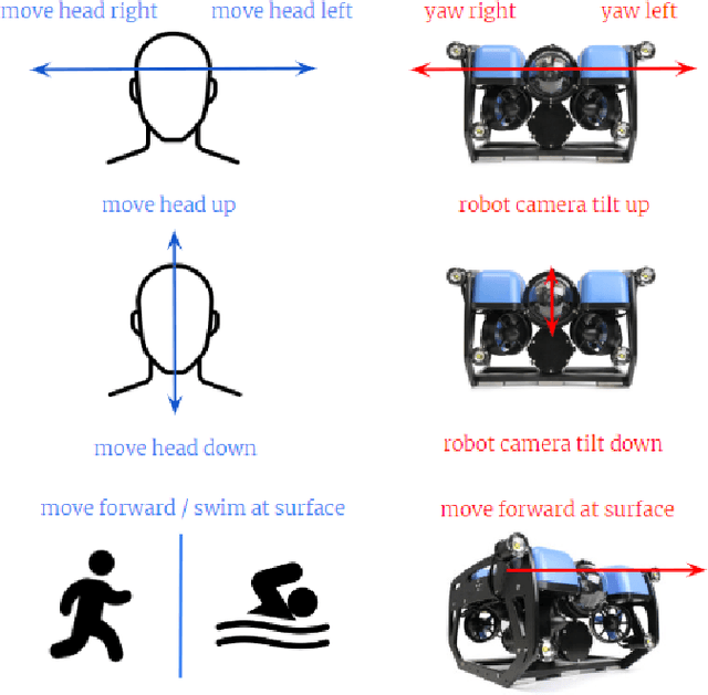
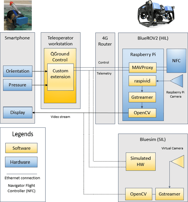
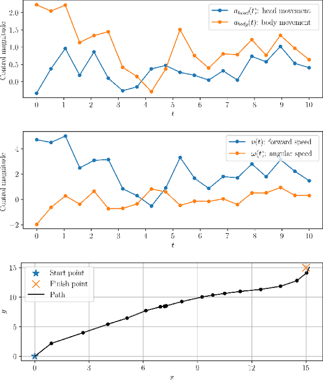
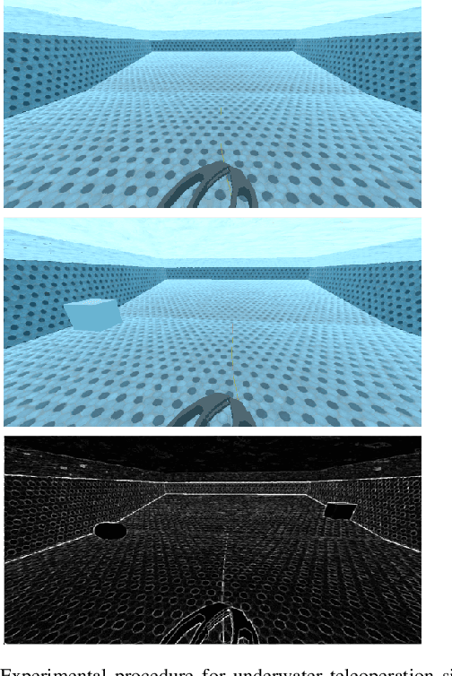
Efficient and intuitive Human-Robot interfaces are crucial for expanding the user base of operators and enabling new applications in critical areas such as precision agriculture, automated construction, rehabilitation, and environmental monitoring. In this paper, we investigate the design of human-robot interfaces for the teleoperation of dynamical systems. The proposed framework seeks to find an optimal interface that complies with key concepts such as user comfort, efficiency, continuity, and consistency. As a proof-of-concept, we introduce an innovative approach to teleoperating underwater vehicles, allowing the translation between human body movements into vehicle control commands. This method eliminates the need for divers to work in harsh underwater environments while taking into account comfort and communication constraints. We conducted a study with human subjects using a head-mounted display attached to a smartphone to control a simulated ROV. Also, numerical experiments have demonstrated that the optimal translation is often the most intuitive and natural one, aligning with users' expectations.
Feedback Motion Planning for Long-Range Autonomous Underwater Vehicles
Nov 21, 2019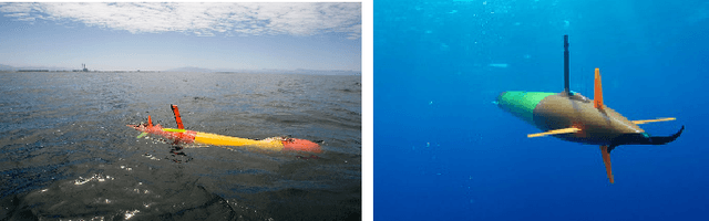
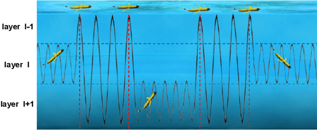
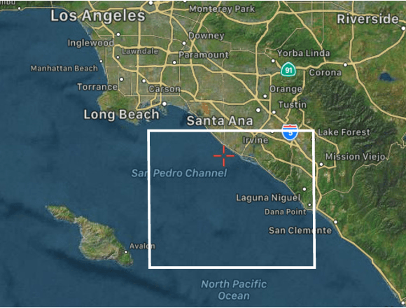
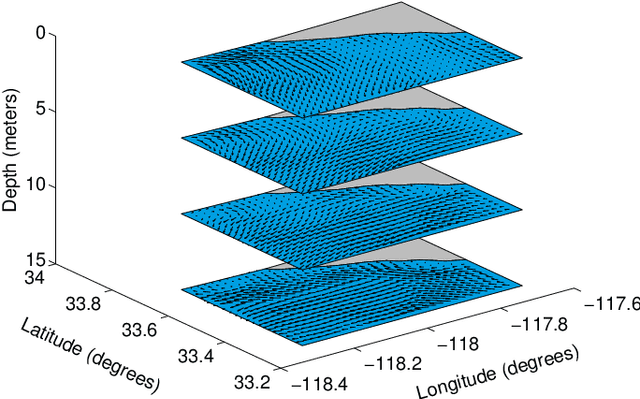
Ocean ecosystems have spatiotemporal variability and dynamic complexity that require a long-term deployment of an autonomous underwater vehicle for data collection. A new long-range autonomous underwater vehicle called Tethys is adapted to study different oceanic phenomena. Additionally, an ocean environment has external forces and moments along with changing water currents which are generally not considered in a vehicle kinematic model. In this scenario, it is not enough to generate a simple trajectory from an initial location to a goal location in an uncertain ocean as the vehicle can deviate from its intended trajectory. As such, we propose to compute a feedback plan that adapts the vehicle trajectory in the presence of any modeled or unmodeled uncertainties. In this work, we present a feedback motion planning method for the Tethys vehicle by combining a predictive ocean model and its kinematic modeling. Given a goal location, the Tethys kinematic model, and the water flow pattern, our method computes a feedback plan for the vehicle in a dynamic ocean environment that reduces its energy consumption. The computed feedback plan provides the optimal action for the Tethys vehicle to take from any location of the environment to reach the goal location considering its orientation. Our results based on actual ocean model prediction data demonstrate the applicability of our method.