 Add to Chrome
 Add to Firefox
 Add to Edge
Global atmospheric data assimilation with multi-modal masked autoencoders
Jul 16, 2024Global data assimilation enables weather forecasting at all scales and provides valuable data for studying the Earth system. However, the computational demands of physics-based algorithms used in operational systems limits the volume and diversity of observations that are assimilated. Here, we present "EarthNet", a multi-modal foundation model for data assimilation that learns to predict a global gap-filled atmospheric state solely from satellite observations. EarthNet is trained as a masked autoencoder that ingests a 12 hour sequence of observations and learns to fill missing data from other sensors. We show that EarthNet performs a form of data assimilation producing a global 0.16 degree reanalysis dataset of 3D atmospheric temperature and humidity at a fraction of the time compared to operational systems. It is shown that the resulting reanalysis dataset reproduces climatology by evaluating a 1 hour forecast background state against observations. We also show that our 3D humidity predictions outperform MERRA-2 and ERA5 reanalyses by 10% to 60% between the middle troposphere and lower stratosphere (5 to 20 km altitude) and our 3D temperature and humidity are statistically equivalent to the Microwave integrated Retrieval System (MiRS) observations at nearly every level of the atmosphere. Our results indicate significant promise in using EarthNet for high-frequency data assimilation and global weather forecasting.
Explainable deep learning for insights in El Nino and river flows
Jan 12, 2022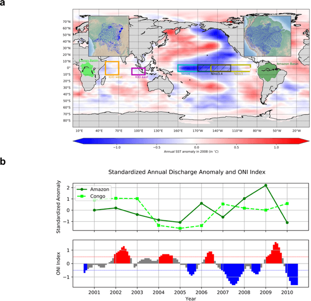
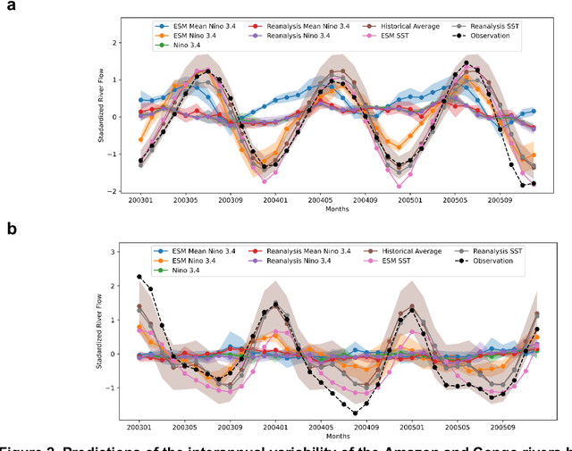
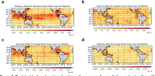
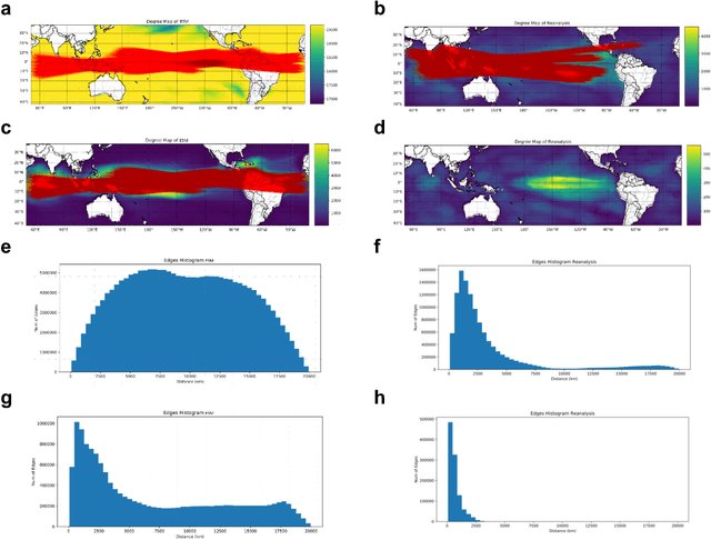
The El Nino Southern Oscillation (ENSO) is a semi-periodic fluctuation in sea surface temperature (SST) over the tropical central and eastern Pacific Ocean that influences interannual variability in regional hydrology across the world through long-range dependence or teleconnections. Recent research has demonstrated the value of Deep Learning (DL) methods for improving ENSO prediction as well as Complex Networks (CN) for understanding teleconnections. However, gaps in predictive understanding of ENSO-driven river flows include the black box nature of DL, the use of simple ENSO indices to describe a complex phenomenon and translating DL-based ENSO predictions to river flow predictions. Here we show that eXplainable DL (XDL) methods, based on saliency maps, can extract interpretable predictive information contained in global SST and discover novel SST information regions and dependence structures relevant for river flows which, in tandem with climate network constructions, enable improved predictive understanding. Our results reveal additional information content in global SST beyond ENSO indices, develop new understanding of how SSTs influence river flows, and generate improved river flow predictions with uncertainties. Observations, reanalysis data, and earth system model simulations are used to demonstrate the value of the XDL-CN based methods for future interannual and decadal scale climate projections.
Deep Learning Emulation of Multi-Angle Implementation of Atmospheric Correction (MAIAC)
Oct 29, 2019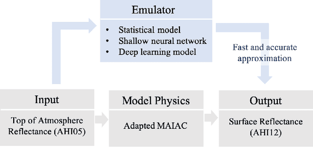
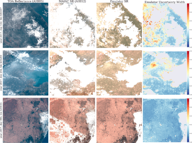
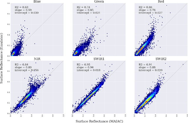
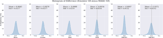
New generation geostationary satellites make solar reflectance observations available at a continental scale with unprecedented spatiotemporal resolution and spectral range. Generating quality land monitoring products requires correction of the effects of atmospheric scattering and absorption, which vary in time and space according to geometry and atmospheric composition. Many atmospheric radiative transfer models, including that of Multi-Angle Implementation of Atmospheric Correction (MAIAC), are too computationally complex to be run in real time, and rely on precomputed look-up tables. Additionally, uncertainty in measurements and models for remote sensing receives insufficient attention, in part due to the difficulty of obtaining sufficient ground measurements. In this paper, we present an adaptation of Bayesian Deep Learning (BDL) to emulation of the MAIAC atmospheric correction algorithm. Emulation approaches learn a statistical model as an efficient approximation of a physical model, while machine learning methods have demonstrated performance in extracting spatial features and learning complex, nonlinear mappings. We demonstrate stable surface reflectance retrieval by emulation (R2 between MAIAC and emulator SR are 0.63, 0.75, 0.86, 0.84, 0.95, and 0.91 for Blue, Green, Red, NIR, SWIR1, and SWIR2 bands, respectively), accurate cloud detection (86\%), and well-calibrated, geolocated uncertainty estimates. Our results support BDL-based emulation as an accurate and efficient (up to 6x speedup) method for approximation atmospheric correction, where built-in uncertainty estimates stand to open new opportunities for model assessment and support informed use of SR-derived quantities in multiple domains.
Progressively Growing Generative Adversarial Networks for High Resolution Semantic Segmentation of Satellite Images
Feb 12, 2019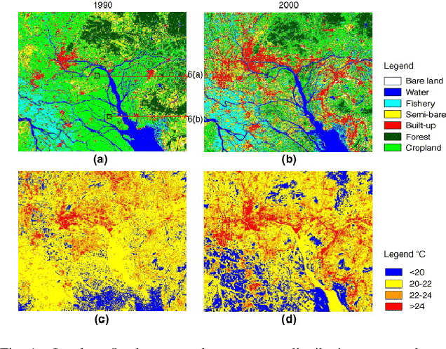
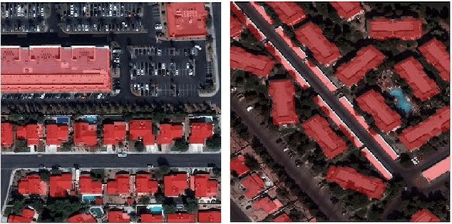
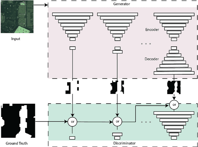
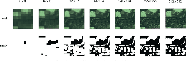
Machine learning has proven to be useful in classification and segmentation of images. In this paper, we evaluate a training methodology for pixel-wise segmentation on high resolution satellite images using progressive growing of generative adversarial networks. We apply our model to segmenting building rooftops and compare these results to conventional methods for rooftop segmentation. We present our findings using the SpaceNet version 2 dataset. Progressive GAN training achieved a test accuracy of 93% compared to 89% for traditional GAN training.