 Add to Chrome
 Add to Firefox
 Add to Edge
Is Fairness Truly Fair? Towards Reliable Lipschitz Fairness in Multi-Task Learning via Fixed-\texorpdfstring{$δ$}{delta} Alignment
Jun 09, 2026Lipschitz-style individual fairness formalizes the idea that semantically similar examples should receive similar predictions, but its evaluation in multi-task learning (MTL) can be confounded by method-induced representation scales. This paper identifies threshold confounding: when the auditing tolerance is derived from each model's own representation distances, different algorithms are compared under different semantic thresholds. A threshold-drift analysis further shows how Bias rankings can change and identifies sufficient conditions for ranking preservation. We propose \textbf{ReLiF}, a reliability-aware framework that separates evaluation-time fixed-$δ$ auditing from training-time controlled regularization. ReLiF uses a shared reference tolerance for comparable auditing and a violation-rate feedback controller to keep the Lipschitz surrogate active without letting it dominate stochastic training. This work also develops supporting analysis for threshold drift, reference-tolerance selection, and the relationship between the huberized training surrogate and its unsmoothed positive-margin counterpart. Experiments on clinical time-series benchmarks and NYUv2 (NYU Depth V2) dense prediction show that fixed-$δ$ auditing exposes utility--fairness trade-offs that method-dependent thresholds can obscure. On NYUv2 with a ResNet50 backbone, ReLiF achieves competitive utility while substantially reducing aligned bias under shared fixed thresholds. On clinical benchmarks, ReLiF yields controlled fairness-regularized trade-offs, while fixed-$δ$ auditing reveals that task-balancing baselines can sometimes achieve lower bias and that genuine utility--fairness trade-offs persist. These results support fixed-$δ$ auditing as a semantically consistent protocol for evaluating Lipschitz fairness in MTL.
Research on Foundation Model for Spatial Data Intelligence: China's 2024 White Paper on Strategic Development of Spatial Data Intelligence
May 30, 2024This report focuses on spatial data intelligent large models, delving into the principles, methods, and cutting-edge applications of these models. It provides an in-depth discussion on the definition, development history, current status, and trends of spatial data intelligent large models, as well as the challenges they face. The report systematically elucidates the key technologies of spatial data intelligent large models and their applications in urban environments, aerospace remote sensing, geography, transportation, and other scenarios. Additionally, it summarizes the latest application cases of spatial data intelligent large models in themes such as urban development, multimodal systems, remote sensing, smart transportation, and resource environments. Finally, the report concludes with an overview and outlook on the development prospects of spatial data intelligent large models.
DeepSSN: a deep convolutional neural network to assess spatial scene similarity
Feb 07, 2022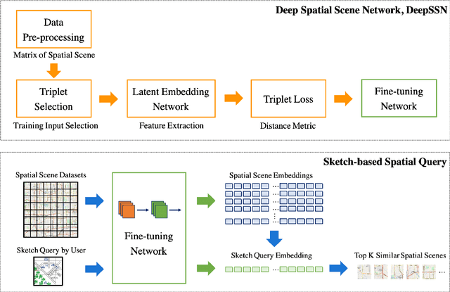
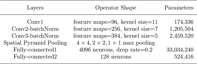
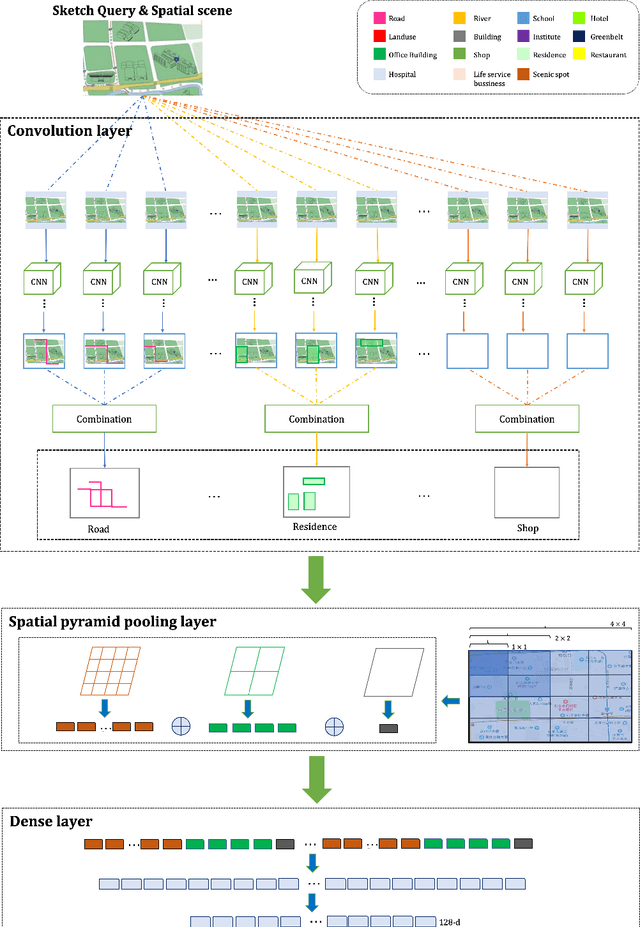
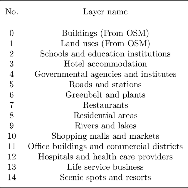
Spatial-query-by-sketch is an intuitive tool to explore human spatial knowledge about geographic environments and to support communication with scene database queries. However, traditional sketch-based spatial search methods perform insufficiently due to their inability to find hidden multi-scale map features from mental sketches. In this research, we propose a deep convolutional neural network, namely Deep Spatial Scene Network (DeepSSN), to better assess the spatial scene similarity. In DeepSSN, a triplet loss function is designed as a comprehensive distance metric to support the similarity assessment. A positive and negative example mining strategy using qualitative constraint networks in spatial reasoning is designed to ensure a consistently increasing distinction of triplets during the training process. Moreover, we develop a prototype spatial scene search system using the proposed DeepSSN, in which the users input spatial query via sketch maps and the system can automatically augment the sketch training data. The proposed model is validated using multi-source conflated map data including 131,300 labeled scene samples after data augmentation. The empirical results demonstrate that the DeepSSN outperforms baseline methods including k-nearest-neighbors, multilayer perceptron, AlexNet, DenseNet, and ResNet using mean reciprocal rank and precision metrics. This research advances geographic information retrieval studies by introducing a novel deep learning method tailored to spatial scene queries.
* 28 pages, 10 figures, 8 tables