 Add to Chrome
 Add to Firefox
 Add to Edge
Automated Quality Assessment of Geospatial Vector Data: A GeoAI Approach using Spatial Representation Learning
Jun 23, 2026
Geospatial vector data quality is a foundational research topic in GIS, yet classic rule-based quality assessment algorithms often struggle with diverse urban morphologies and massive data volumes. Recently, Geospatial Artificial Intelligence (GeoAI) shows promising potential for automating geospatial analysis, while its application to native vector data remains largely underexplored. To fill this research gap, we proposed Topo4Vec, an automated GeoAI framework, designed for scalable vector data quality assessment via advanced Spatial Representation Learning (SRL). Specifically, Topo4Vec relax the labor-intensive manual annotation process via topological error simulation, such as overlapping polygons and street network connectivity errors e.g., overshoots and undershoots. Then, it leverages state-of-the-art SRL approaches to encode complex, native vector geometries (e.g., polylines and polygons) into a latent space where topological errors are isolated from valid ones. A systematic performance evaluation across three study areas (Los Angeles, Munich, and Singapore) demonstrates the effectiveness and robustness of Topo4Vec, achieving a peak accuracy of 0.99 for detecting overlapping building footprints and 0.60 for overshoots and undershoots in street networks. Moreover, lessons learned from Topo4Vec shed a promising light into a scalable and autonomous GeoAI approach for large-scale vector data consistency and quality monitoring within the fast-growing geospatial data ecosystems. The code and data used in the paper are made openly available in https://figshare.com/s/612148eeb4bccadbd715.

IBAD: Interpretable Behavioral Anomaly Detection on Human Mobility Data
Jun 14, 2026Human mobility appears highly diverse, yet much of a person's daily mobility can be explained by a small set of recurring behavioral templates, such as commuting, school-centered activities, caregiving, nightlife, or errand patterns. We present \texttt{IBAD} (\underline{I}nterpretable \underline{B}ehavioral \underline{A}nomaly \underline{D}etection), a framework that learns interpretable daily mobility templates and represents each individual as a distribution over mixtures of these templates. Rather than focusing on specific locations, IBAD characterizes activities that individuals perform across locations. This approach first discovers global behavioral templates using Latent Dirichlet Allocation (LDA), then employs a hierarchical self-supervised model to learn normal behavior of individuals from their soft behavioral templates. We also introduce a \emph{splicing benchmark} that creates controlled behavioral mismatches between an individual's historical profile and injected mobility patterns. Experiments on real-world and synthetic datasets show that daily behavior can be effectively decomposed into a small number of interpretable templates. Crucially, we show that the learned behavioral archetypes \emph{transfer} across distinct geographic and demographic contexts. Furthermore, IBAD maintains a robust competitive performance across all settings. For reproducibility purposes, the code is accessible at ~\href{https://github.com/USC-InfoLab/IBAD}{https://github.com/USC-InfoLab/IBAD}.
GeoGNN: Time Series Geo-Localization using Two-Tower Graph Neural Networks
Jun 06, 2026This paper investigates a novel concept of time series geolocalization, where the goal is to infer the geographic origin of each raw time series. Successful geolocalization can provide spatial context to time series, enabling downstream location-aware applications. We formalize the problem, adapt core ideas from image geolocalization to establish strong baselines, and propose GeoGNN, a two-tower architecture. During training, GeoGNN's spatial tower learns embeddings of geographic cell candidates by leveraging the geographic adjacency graph, while the temporal tower extracts informative representations from time series. During inference, each temporal representation is matched against candidate geographic embeddings using dot-product similarity, combined with an auxiliary classification head, to predict the time series' associated geographic origin. Experiments on large-scale, countrywide electricity-consumption datasets demonstrate that GeoGNN achieves the best performance across datasets and enhances both fine- and coarse-grained geolocalization accuracy by ~27% on average.
From Symbolic to Geometric: Enabling Spatial Reasoning in Large Language Models
Jun 03, 2026Recent large language models (LLMs) often appear to exhibit spatial reasoning ability; however, this capability is largely \emph{symbolic}, arising from pattern matching over spatial language rather than true \emph{geometric} reasoning over space. Because LLMs operate on discrete tokens, they lack native support for continuous spatial representations, explicit geometric computation, and structured spatial operators. To address this limitation, we introduce the \emph{Spatial Language Model (SLM)}, the first multimodal LLM that treats location information as a first-class modality and enables geometric spatial reasoning within the model's inference process. SLM directly operates on learned spatial representations rather than textual descriptions of spatial relations. To support effective training, we construct a \emph{Spatial Instruction Dataset} that aligns spatial representations, atomic geometric operations, and natural language instructions. We further propose a new benchmark named \emph{SpatialEval}, which is designed to evaluate spatial reasoning across attributes, distance, topology, and relative-position tasks. Extensive experiments show that SLM significantly outperforms existing LLM-based approaches that rely on symbolic reasoning via prompt engineering or textual abstraction, demonstrating the benefits of integrating geometric spatial representations for robust spatial reasoning. Our instruction dataset, evaluation benchmark, model training codes, and models' checkpoints can be found at: \hyperlink{https://github.com/chuchen2017/SLM}{https://github.com/chuchen2017/SLM}.
TrajTok: Adaptive Spatial Tokenization for Trajectory Representation Learning
May 19, 2026Learning generalizable trajectory representations from raw GPS traces remains difficult because the data is continuous, noisy, and irregularly sampled. Spatial tokenization is also challenging: fine grids yield sparse cells with weak embeddings, while coarse grids merge heterogeneous movement patterns into the same token. We present TrajTok, a trajectory encoder with a simple pretraining recipe for transferable trajectory embeddings. TrajTok first learns a multi-resolution hexagonal cell partition from the spatial distribution of GPS points, converting noisy GPS sequences into discrete cell tokens. To capture both geometry and kinematics, it uses a factorized transformer encoder with early per-modality self-attention blocks, cross-attention fusion layers, and spatiotemporal rotary position embeddings, ST-RoPE, to encode where and when each token occurs. TrajTok is pretrained with masked-token modeling that recovers both geometric structure and kinematic patterns from partial trajectory observations. On the Porto dataset, a frozen TrajTok encoder with lightweight task adapters achieves strong performance across trajectory similarity search, classification, estimated time of arrival, and full travel-time regression, outperforming multiple task-specific methods. The same frozen encoder supports both geometry-dominated and kinematics-dominated tasks, suggesting that TrajTok learns transferable trajectory structure rather than task-specific shortcuts. These results indicate that learned multi-resolution spatial tokenization combined with masked-token pretraining is a promising direction for general-purpose trajectory foundation models.
Mobility-Embedded POIs: Learning What A Place Is and How It Is Used from Human Movement
Jan 29, 2026Recent progress in geospatial foundation models highlights the importance of learning general-purpose representations for real-world locations, particularly points-of-interest (POIs) where human activity concentrates. Existing approaches, however, focus primarily on place identity derived from static textual metadata, or learn representations tied to trajectory context, which capture movement regularities rather than how places are actually used (i.e., POI's function). We argue that POI function is a missing but essential signal for general POI representations. We introduce Mobility-Embedded POIs (ME-POIs), a framework that augments POI embeddings derived, from language models with large-scale human mobility data to learn POI-centric, context-independent representations grounded in real-world usage. ME-POIs encodes individual visits as temporally contextualized embeddings and aligns them with learnable POI representations via contrastive learning to capture usage patterns across users and time. To address long-tail sparsity, we propose a novel mechanism that propagates temporal visit patterns from nearby, frequently visited POIs across multiple spatial scales. We evaluate ME-POIs on five newly proposed map enrichment tasks, testing its ability to capture both the identity and function of POIs. Across all tasks, augmenting text-based embeddings with ME-POIs consistently outperforms both text-only and mobility-only baselines. Notably, ME-POIs trained on mobility data alone can surpass text-only models on certain tasks, highlighting that POI function is a critical component of accurate and generalizable POI representations.
Geo2Vec: Shape- and Distance-Aware Neural Representation of Geospatial Entities
Aug 26, 2025Spatial representation learning is essential for GeoAI applications such as urban analytics, enabling the encoding of shapes, locations, and spatial relationships (topological and distance-based) of geo-entities like points, polylines, and polygons. Existing methods either target a single geo-entity type or, like Poly2Vec, decompose entities into simpler components to enable Fourier transformation, introducing high computational cost. Moreover, since the transformed space lacks geometric alignment, these methods rely on uniform, non-adaptive sampling, which blurs fine-grained features like edges and boundaries. To address these limitations, we introduce Geo2Vec, a novel method inspired by signed distance fields (SDF) that operates directly in the original space. Geo2Vec adaptively samples points and encodes their signed distances (positive outside, negative inside), capturing geometry without decomposition. A neural network trained to approximate the SDF produces compact, geometry-aware, and unified representations for all geo-entity types. Additionally, we propose a rotation-invariant positional encoding to model high-frequency spatial variations and construct a structured and robust embedding space for downstream GeoAI models. Empirical results show that Geo2Vec consistently outperforms existing methods in representing shape and location, capturing topological and distance relationships, and achieving greater efficiency in real-world GeoAI applications. Code and Data can be found at: https://github.com/chuchen2017/GeoNeuralRepresentation.
Small Graph Is All You Need: DeepStateGNN for Scalable Traffic Forecasting
Feb 20, 2025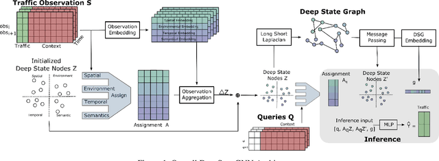
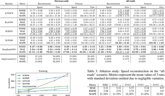
We propose a novel Graph Neural Network (GNN) model, named DeepStateGNN, for analyzing traffic data, demonstrating its efficacy in two critical tasks: forecasting and reconstruction. Unlike typical GNN methods that treat each traffic sensor as an individual graph node, DeepStateGNN clusters sensors into higher-level graph nodes, dubbed Deep State Nodes, based on various similarity criteria, resulting in a fixed number of nodes in a Deep State graph. The term "Deep State" nodes is a play on words, referencing hidden networks of power that, like these nodes, secretly govern traffic independently of visible sensors. These Deep State Nodes are defined by several similarity factors, including spatial proximity (e.g., sensors located nearby in the road network), functional similarity (e.g., sensors on similar types of freeways), and behavioral similarity under specific conditions (e.g., traffic behavior during rain). This clustering approach allows for dynamic and adaptive node grouping, as sensors can belong to multiple clusters and clusters may evolve over time. Our experimental results show that DeepStateGNN offers superior scalability and faster training, while also delivering more accurate results than competitors. It effectively handles large-scale sensor networks, outperforming other methods in both traffic forecasting and reconstruction accuracy.
WaveGNN: Modeling Irregular Multivariate Time Series for Accurate Predictions
Dec 14, 2024
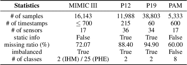
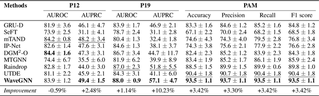

Accurately modeling and analyzing time series data is crucial for downstream applications across various fields, including healthcare, finance, astronomy, and epidemiology. However, real-world time series often exhibit irregularities such as misaligned timestamps, missing entries, and variable sampling rates, complicating their analysis. Existing approaches often rely on imputation, which can introduce biases. A few approaches that directly model irregularity tend to focus exclusively on either capturing intra-series patterns or inter-series relationships, missing the benefits of integrating both. To this end, we present WaveGNN, a novel framework designed to directly (i.e., no imputation) embed irregularly sampled multivariate time series data for accurate predictions. WaveGNN utilizes a Transformer-based encoder to capture intra-series patterns by directly encoding the temporal dynamics of each time series. To capture inter-series relationships, WaveGNN uses a dynamic graph neural network model, where each node represents a sensor, and the edges capture the long- and short-term relationships between them. Our experimental results on real-world healthcare datasets demonstrate that WaveGNN consistently outperforms existing state-of-the-art methods, with an average relative improvement of 14.7% in F1-score when compared to the second-best baseline in cases with extreme sparsity. Our ablation studies reveal that both intra-series and inter-series modeling significantly contribute to this notable improvement.
Forecasting Unseen Points of Interest Visits Using Context and Proximity Priors
Nov 22, 2024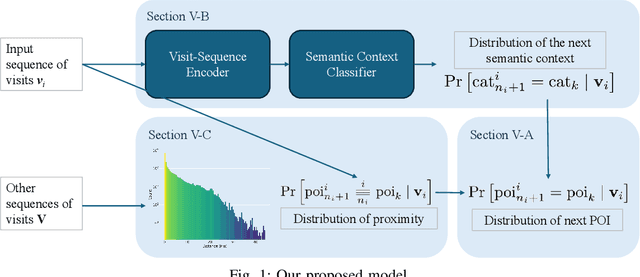
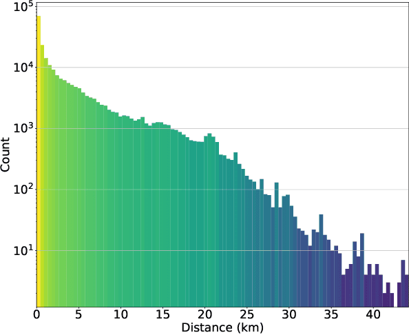
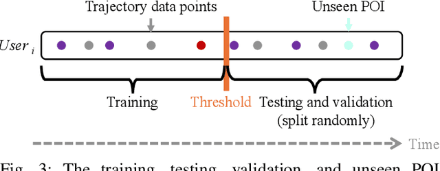
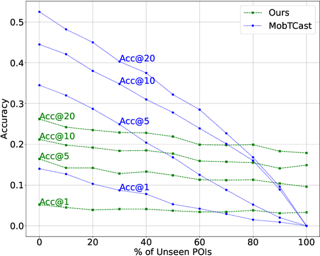
Understanding human mobility behavior is crucial for numerous applications, including crowd management, location-based recommendations, and the estimation of pandemic spread. Machine learning models can predict the Points of Interest (POIs) that individuals are likely to visit in the future by analyzing their historical visit patterns. Previous studies address this problem by learning a POI classifier, where each class corresponds to a POI. However, this limits their applicability to predict a new POI that was not in the training data, such as the opening of new restaurants. To address this challenge, we propose a model designed to predict a new POI outside the training data as long as its context is aligned with the user's interests. Unlike existing approaches that directly predict specific POIs, our model first forecasts the semantic context of potential future POIs, then combines this with a proximity-based prior probability distribution to determine the exact POI. Experimental results on real-world visit data demonstrate that our model outperforms baseline methods that do not account for semantic contexts, achieving a 17% improvement in accuracy. Notably, as new POIs are introduced over time, our model remains robust, exhibiting a lower decline rate in prediction accuracy compared to existing methods.