 Add to Chrome
 Add to Firefox
 Add to Edge
Emerging Flexible Designs for Geospatial Multimodal Foundation Models
Jun 10, 2026
Foundation models are rapidly transforming Earth observation by enabling scalable pretraining across diverse unlabeled geospatial modalities. However, their architectural diversity ranging from encoder-only to encoder-decoder and masked autoencoding paradigms makes it challenging to assess performance trade offs in a consistent manner. In this work, we present an apples-to-apples comparison of leading FM architectures designed for geospatial multimodal reasoning, with a particular focus on flexibility across varied spectral band configurations. We standardize pretraining using identical self supervised learning objectives and training datasets, and evaluate all models under consistent parameterization on the GEOBench benchmark across classification and segmentation tasks. Our results offer new insights into the design trade-offs between model flexibility, modality alignment, and downstream task performance. By highlighting architectural strengths and limitations under controlled conditions, this study provides practical guidance for building next generation geospatial foundation models capable of robust multimodal reasoning.

GeoGNN: Time Series Geo-Localization using Two-Tower Graph Neural Networks
Jun 06, 2026This paper investigates a novel concept of time series geolocalization, where the goal is to infer the geographic origin of each raw time series. Successful geolocalization can provide spatial context to time series, enabling downstream location-aware applications. We formalize the problem, adapt core ideas from image geolocalization to establish strong baselines, and propose GeoGNN, a two-tower architecture. During training, GeoGNN's spatial tower learns embeddings of geographic cell candidates by leveraging the geographic adjacency graph, while the temporal tower extracts informative representations from time series. During inference, each temporal representation is matched against candidate geographic embeddings using dot-product similarity, combined with an auxiliary classification head, to predict the time series' associated geographic origin. Experiments on large-scale, countrywide electricity-consumption datasets demonstrate that GeoGNN achieves the best performance across datasets and enhances both fine- and coarse-grained geolocalization accuracy by ~27% on average.
OReole-FM: successes and challenges toward billion-parameter foundation models for high-resolution satellite imagery
Oct 25, 2024While the pretraining of Foundation Models (FMs) for remote sensing (RS) imagery is on the rise, models remain restricted to a few hundred million parameters. Scaling models to billions of parameters has been shown to yield unprecedented benefits including emergent abilities, but requires data scaling and computing resources typically not available outside industry R&D labs. In this work, we pair high-performance computing resources including Frontier supercomputer, America's first exascale system, and high-resolution optical RS data to pretrain billion-scale FMs. Our study assesses performance of different pretrained variants of vision Transformers across image classification, semantic segmentation and object detection benchmarks, which highlight the importance of data scaling for effective model scaling. Moreover, we discuss construction of a novel TIU pretraining dataset, model initialization, with data and pretrained models intended for public release. By discussing technical challenges and details often lacking in the related literature, this work is intended to offer best practices to the geospatial community toward efficient training and benchmarking of larger FMs.
Pretraining Billion-scale Geospatial Foundational Models on Frontier
Apr 17, 2024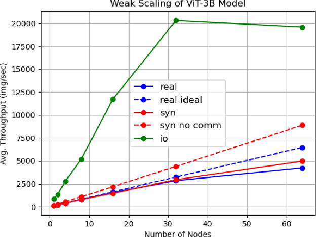
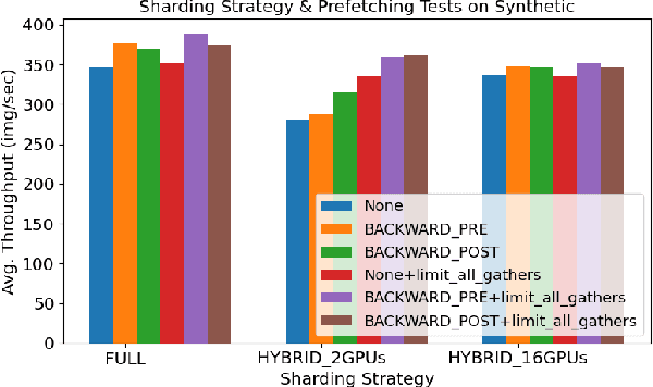
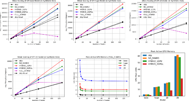
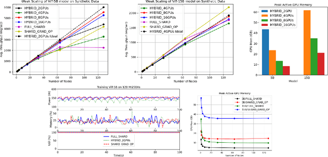
As AI workloads increase in scope, generalization capability becomes challenging for small task-specific models and their demand for large amounts of labeled training samples increases. On the contrary, Foundation Models (FMs) are trained with internet-scale unlabeled data via self-supervised learning and have been shown to adapt to various tasks with minimal fine-tuning. Although large FMs have demonstrated significant impact in natural language processing and computer vision, efforts toward FMs for geospatial applications have been restricted to smaller size models, as pretraining larger models requires very large computing resources equipped with state-of-the-art hardware accelerators. Current satellite constellations collect 100+TBs of data a day, resulting in images that are billions of pixels and multimodal in nature. Such geospatial data poses unique challenges opening up new opportunities to develop FMs. We investigate billion scale FMs and HPC training profiles for geospatial applications by pretraining on publicly available data. We studied from end-to-end the performance and impact in the solution by scaling the model size. Our larger 3B parameter size model achieves up to 30% improvement in top1 scene classification accuracy when comparing a 100M parameter model. Moreover, we detail performance experiments on the Frontier supercomputer, America's first exascale system, where we study different model and data parallel approaches using PyTorch's Fully Sharded Data Parallel library. Specifically, we study variants of the Vision Transformer architecture (ViT), conducting performance analysis for ViT models with size up to 15B parameters. By discussing throughput and performance bottlenecks under different parallelism configurations, we offer insights on how to leverage such leadership-class HPC resources when developing large models for geospatial imagery applications.