 Add to Chrome
 Add to Firefox
 Add to Edge
Global monitoring of methane point sources using deep learning on hyperspectral radiance measurements from EMIT
Apr 11, 2026Anthropogenic methane (CH4) point sources drive near-term climate forcing, safety hazards, and system inefficiencies. Space-based imaging spectroscopy is emerging as a tool for identifying emissions globally, but existing approaches largely rely on manual plume identification. Here we present the Methane Analysis and Plume Localization with EMIT (MAPL-EMIT) model, an end-to-end vision transformer framework that leverages the complete radiance spectrum from the Earth Surface Mineral Dust Source Investigation (EMIT) instrument to jointly retrieve methane enhancements across all pixels within a scene. This approach brings together spectral and spatial context to significantly lower detection limits. MAPL-EMIT simultaneously supports enhancement quantification, plume delineation, and source localization, even for multiple overlapping plumes. The model was trained on 3.6 million physics-based synthetic plumes injected into global EMIT radiance data. Synthetic evaluation confirms the model's ability to identify plumes with high recall and precision and to capture weaker plumes relative to existing matched-filter approaches. On real-world benchmarks, MAPL-EMIT captures 79% of known hand-annotated NASA L2B plume complexes across a test set of 1084 EMIT granules, while capturing twice as many plausible plumes than identified by human analysts. Further validation against coincident airborne data, top-emitting landfills, and controlled release experiments confirms the model's ability to identify previously uncaptured sources. By incorporating model-generated metrics such as spectral fit scores and estimated noise levels, the framework can further limit false-positive rates. Overall, MAPL-EMIT enables high-throughput implementation on the full EMIT catalog, shifting methane monitoring from labor-intensive workflows to a rapid, scalable paradigm for global plume mapping at the facility scale.
Agricultural Landscape Understanding At Country-Scale
Nov 08, 2024Agricultural landscapes are quite complex, especially in the Global South where fields are smaller, and agricultural practices are more varied. In this paper we report on our progress in digitizing the agricultural landscape (natural and man-made) in our study region of India. We use high resolution imagery and a UNet style segmentation model to generate the first of its kind national-scale multi-class panoptic segmentation output. Through this work we have been able to identify individual fields across 151.7M hectares, and delineating key features such as water resources and vegetation. We share how this output was validated by our team and externally by downstream users, including some sample use cases that can lead to targeted data driven decision making. We believe this dataset will contribute towards digitizing agriculture by generating the foundational baselayer.
Satellite Sunroof: High-res Digital Surface Models and Roof Segmentation for Global Solar Mapping
Aug 26, 2024


The transition to renewable energy, particularly solar, is key to mitigating climate change. Google's Solar API aids this transition by estimating solar potential from aerial imagery, but its impact is constrained by geographical coverage. This paper proposes expanding the API's reach using satellite imagery, enabling global solar potential assessment. We tackle challenges involved in building a Digital Surface Model (DSM) and roof instance segmentation from lower resolution and single oblique views using deep learning models. Our models, trained on aligned satellite and aerial datasets, produce 25cm DSMs and roof segments. With ~1m DSM MAE on buildings, ~5deg roof pitch error and ~56% IOU on roof segmentation, they significantly enhance the Solar API's potential to promote solar adoption.
Estimating Residential Solar Potential Using Aerial Data
Jun 23, 2023


Project Sunroof estimates the solar potential of residential buildings using high quality aerial data. That is, it estimates the potential solar energy (and associated financial savings) that can be captured by buildings if solar panels were to be installed on their roofs. Unfortunately its coverage is limited by the lack of high resolution digital surface map (DSM) data. We present a deep learning approach that bridges this gap by enhancing widely available low-resolution data, thereby dramatically increasing the coverage of Sunroof. We also present some ongoing efforts to potentially improve accuracy even further by replacing certain algorithmic components of the Sunroof processing pipeline with deep learning.
Multimodal contrastive learning for remote sensing tasks
Sep 06, 2022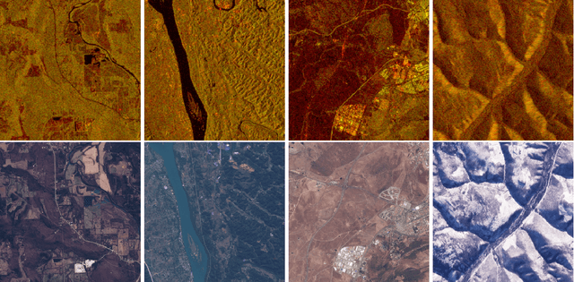
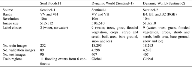
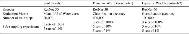
Self-supervised methods have shown tremendous success in the field of computer vision, including applications in remote sensing and medical imaging. Most popular contrastive-loss based methods like SimCLR, MoCo, MoCo-v2 use multiple views of the same image by applying contrived augmentations on the image to create positive pairs and contrast them with negative examples. Although these techniques work well, most of these techniques have been tuned on ImageNet (and similar computer vision datasets). While there have been some attempts to capture a richer set of deformations in the positive samples, in this work, we explore a promising alternative to generating positive examples for remote sensing data within the contrastive learning framework. Images captured from different sensors at the same location and nearby timestamps can be thought of as strongly augmented instances of the same scene, thus removing the need to explore and tune a set of hand crafted strong augmentations. In this paper, we propose a simple dual-encoder framework, which is pre-trained on a large unlabeled dataset (~1M) of Sentinel-1 and Sentinel-2 image pairs. We test the embeddings on two remote sensing downstream tasks: flood segmentation and land cover mapping, and empirically show that embeddings learnt from this technique outperform the conventional technique of collecting positive examples via aggressive data augmentations.