 Add to Chrome
 Add to Firefox
 Add to Edge
G2-Nav: Grounded and Guarded Vision-Language Costmaps for Robot Social Navigation
Jul 18, 2026
Social navigation requires the robot to reason and respond in complex real-world environments. While recent works attempt to incorporate human-level intelligence into robot planning using large Vision-Language Models (VLMs), end-to-end frameworks often create an unpredictable black-box, and existing instruction-following methods are not designed for full autonomy. To bridge this gap, we present G2-Nav, a novel framework that grounds abstract social reasoning and guards safe real-world deployment. Instead of asking the VLM for direct planning decisions, G2-Nav translates its semantic reasoning into a vision-language costmap with reliability and interpretability. The VLM evaluates traversable regions and social agents from open-set perception, mapping social context into the costmap. To improve real-world robustness, the VLM performs semantic verification on upstream tracking, and we introduce a high-frequency safety check to guard against system latency prior to trajectory generation. We demonstrate through real-world experiments that G2-Nav delivers safe, efficient, and socially compliant autonomous navigation in unstructured environments. Code will be made publicly available.

From Sketch Prior to Trajectories: A Mission-Oriented Coordinated Navigation Framework for Indoor UAV Swarm
Jul 13, 2026UAV swarm for applications, such as indoor inspection, security patrol, and logistics delivery, are often mission-oriented rather than exploration-oriented. In these tasks, UAVs are required to visit task-relevant regions in a prescribed sequence, and such region-level mission information can often be obtained from pre-deployment sketch-map priors, such as floor plans, CAD layouts, or evacuation diagrams. Although these tasks are executed in three-dimensional space, UAVs usually fly within a specific altitude layer or a nearly fixed altitude range on each floor, making mission-level region transitions mainly governed by planar connectivity. Based on these observations, this paper proposes a mission-oriented coordinated navigation framework that exploits sketch-map priors for multi-UAV indoor operations. Onboard observations are used to perform topological alignment, and the aligned prior is fused with online observations to construct a mission-oriented traversability representation. A layered 2D--3D coordinated navigation framework is further developed, where 2D guided path planning generates mission-oriented guide paths and guide-driven 3D trajectory optimization produces dynamically feasible and collision-free trajectories. Simulation and real-world experiments validate the effectiveness of the proposed framework in structured multi-room indoor environments and further demonstrate its coordinated navigation capability under both communication-available and communication-loss conditions. Multi-floor simulation results show the scalability of the system to layered indoor structures.
FU-MPC: Frontier- and Uncertainty-Aware Model Predictive Control for Efficient and Accurate UAV Exploration with Motorized LiDAR
May 14, 2026Efficient UAV exploration in unknown environments requires rapid coverage expansion while maintaining accurate and reliable localization, since safe navigation in complex scenes depends on consistent mapping and pose estimation. However, for conventional LiDAR-equipped UAVs, the observable region is tightly coupled with the UAV pose and motion. Expanding coverage often requires additional translational or rotational maneuvers, which can reduce exploration efficiency and increase the risk of localization degradation in geometrically challenging environments. Motorized rotating LiDARs provide a promising solution by actively adjusting the sensor viewing direction without changing the UAV motion, thereby introducing an additional sensing degree of freedom. Nevertheless, existing exploration systems rarely exploit this scanning freedom as an explicit decision variable linked to both exploration progress and localization quality. To address this gap, we develop a UAV platform equipped with an independently actuated rotating LiDAR and propose a hierarchical exploration framework. The global planner organizes frontiers into representative viewpoints and sequences them using topology-aware transition costs. Built upon this planner, FU-MPC serves as a local receding-horizon scan controller that optimizes LiDAR rotation along the predicted flight trajectory. The controller jointly considers frontier-aware exploration utility and direction-dependent localization uncertainty, while lightweight surrogate evaluation enables real-time onboard execution. Experiments in complex environments demonstrate that the proposed system improves exploration efficiency while maintaining robust localization performance compared with fixed-pattern scanning and uncertainty-only baselines. The project page can be found at https://kafeiyin00.github.io/FU-MPC/.
S3KF: Spherical State-Space Kalman Filtering for Panoramic 3D Multi-Object Tracking
Mar 29, 2026Panoramic multi-object tracking is important for industrial safety monitoring, wide-area robotic perception, and infrastructure-light deployment in large workspaces. In these settings, the sensing system must provide full-surround coverage, metric geometric cues, and stable target association under wide field-of-view distortion and occlusion. Existing image-plane trackers are tightly coupled to the camera projection and become unreliable in panoramic imagery, while conventional Euclidean 3D formulations introduce redundant directional parameters and do not naturally unify angular, scale, and depth estimation. In this paper, we present $\mathbf{S^3KF}$, a panoramic 3D multi-object tracking framework built on a motorized rotating LiDAR and a quad-fisheye camera rig. The key idea is a geometry-consistent state representation on the unit sphere $\mathbb{S}^2$, where object bearing is modeled by a two-degree-of-freedom tangent-plane parameterization and jointly estimated with box scale and depth dynamics. Based on this state, we derive an extended spherical Kalman filtering pipeline that fuses panoramic camera detections with LiDAR depth observations for multimodal tracking. We further establish a map-based ground-truth generation pipeline using wearable localization devices registered to a shared global LiDAR map, enabling quantitative evaluation without motion-capture infrastructure. Experiments on self-collected real-world sequences show decimeter-level planar tracking accuracy, improved identity continuity over a 2D panoramic baseline in dynamic scenes, and real-time onboard operation on a Jetson AGX Orin platform. These results indicate that the proposed framework is a practical solution for panoramic perception and industrial-scale multi-object tracking.The project page can be found at https://kafeiyin00.github.io/S3KF/.
Line-of-Sight-Constrained Multi-Robot Mapless Navigation via Polygonal Visible Regions
Mar 27, 2026Multi-robot systems rely on underlying connectivity to ensure reliable communication and timely coordination. This paper studies the line-of-sight (LoS) connectivity maintenance problem in multi-robot navigation with unknown obstacles. Prior works typically assume known environment maps to formulate LoS constraints between robots, which hinders their practical deployment. To overcome this limitation, we propose an inherently distributed approach where each robot only constructs an egocentric visible region based on its real-time LiDAR scans, instead of endeavoring to build a global map online. The individual visible regions are shared through distributed communication to establish inter-robot LoS constraints, which are then incorporated into a multi-robot navigation framework to ensure LoS-connectivity. Moreover, we enhance the robustness of connectivity maintenance by proposing a more accurate LoS-distance metric, which further enables flexible topology optimization that eliminates redundant and effort-demanding connections. The proposed framework is evaluated through extensive multi-robot navigation and exploration tasks in both simulation and real-world experiments. Results show that it reliably maintains LoS-connectivity between robots in challenging environments cluttered with obstacles, even under large visible ranges and fragile minimal topologies, where existing methods consistently fail. Ablation studies also reveal that topology optimization boosts navigation efficiency by around $20\%$, demonstrating the framework's potential for efficient navigation under connectivity constraints.
OmniVLN: Omnidirectional 3D Perception and Token-Efficient LLM Reasoning for Visual-Language Navigation across Air and Ground Platforms
Mar 18, 2026Language-guided embodied navigation requires an agent to interpret object-referential instructions, search across multiple rooms, localize the referenced target, and execute reliable motion toward it. Existing systems remain limited in real indoor environments because narrow field-of-view sensing exposes only a partial local scene at each step, often forcing repeated rotations, delaying target discovery, and producing fragmented spatial understanding; meanwhile, directly prompting LLMs with dense 3D maps or exhaustive object lists quickly exceeds the context budget. We present OmniVLN, a zero-shot visual-language navigation framework that couples omnidirectional 3D perception with token-efficient hierarchical reasoning for both aerial and ground robots. OmniVLN fuses a rotating LiDAR and panoramic vision into a hardware-agnostic mapping stack, incrementally constructs a five-layer Dynamic Scene Graph (DSG) from mesh geometry to room- and building-level structure, and stabilizes high-level topology through persistent-homology-based room partitioning and hybrid geometric/VLM relation verification. For navigation, the global DSG is transformed into an agent-centric 3D octant representation with multi-resolution spatial attention prompting, enabling the LLM to progressively filter candidate rooms, infer egocentric orientation, localize target objects, and emit executable navigation primitives while preserving fine local detail and compact long-range memory. Experiments show that the proposed hierarchical interface improves spatial referring accuracy from 77.27\% to 93.18\%, reduces cumulative prompt tokens by up to 61.7\% in cluttered multi-room settings, and improves navigation success by up to 11.68\% over a flat-list baseline. We will release the code and an omnidirectional multimodal dataset to support reproducible research.
Energy-Constrained Navigation for Planetary Rovers under Hybrid RTG-Solar Power
Sep 18, 2025Future planetary exploration rovers must operate for extended durations on hybrid power inputs that combine steady radioisotope thermoelectric generator (RTG) output with variable solar photovoltaic (PV) availability. While energy-aware planning has been studied for aerial and underwater robots under battery limits, few works for ground rovers explicitly model power flow or enforce instantaneous power constraints. Classical terrain-aware planners emphasize slope or traversability, and trajectory optimization methods typically focus on geometric smoothness and dynamic feasibility, neglecting energy feasibility. We present an energy-constrained trajectory planning framework that explicitly integrates physics-based models of translational, rotational, and resistive power with baseline subsystem loads, under hybrid RTG-solar input. By incorporating both cumulative energy budgets and instantaneous power constraints into SE(2)-based polynomial trajectory optimization, the method ensures trajectories that are simultaneously smooth, dynamically feasible, and power-compliant. Simulation results on lunar-like terrain show that our planner generates trajectories with peak power within 0.55 percent of the prescribed limit, while existing methods exceed limits by over 17 percent. This demonstrates a principled and practical approach to energy-aware autonomy for long-duration planetary missions.
AEOS: Active Environment-aware Optimal Scanning Control for UAV LiDAR-Inertial Odometry in Complex Scenes
Sep 11, 2025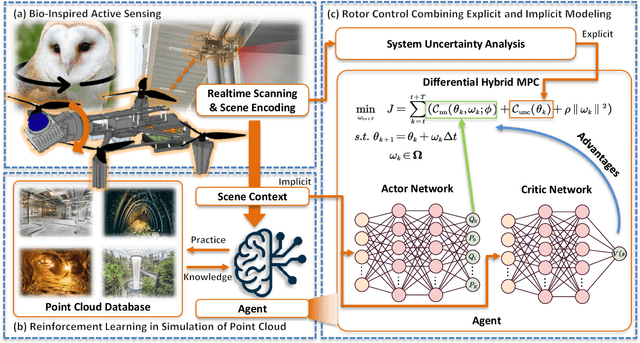

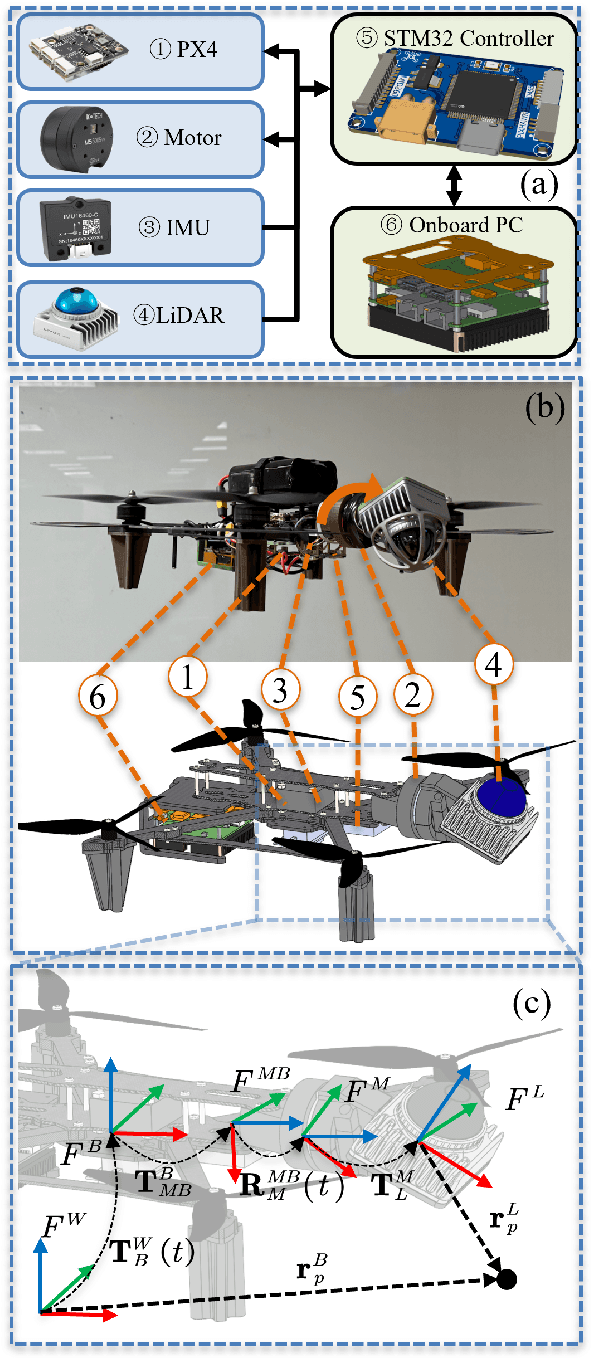
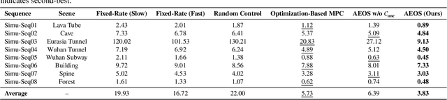
LiDAR-based 3D perception and localization on unmanned aerial vehicles (UAVs) are fundamentally limited by the narrow field of view (FoV) of compact LiDAR sensors and the payload constraints that preclude multi-sensor configurations. Traditional motorized scanning systems with fixed-speed rotations lack scene awareness and task-level adaptability, leading to degraded odometry and mapping performance in complex, occluded environments. Inspired by the active sensing behavior of owls, we propose AEOS (Active Environment-aware Optimal Scanning), a biologically inspired and computationally efficient framework for adaptive LiDAR control in UAV-based LiDAR-Inertial Odometry (LIO). AEOS combines model predictive control (MPC) and reinforcement learning (RL) in a hybrid architecture: an analytical uncertainty model predicts future pose observability for exploitation, while a lightweight neural network learns an implicit cost map from panoramic depth representations to guide exploration. To support scalable training and generalization, we develop a point cloud-based simulation environment with real-world LiDAR maps across diverse scenes, enabling sim-to-real transfer. Extensive experiments in both simulation and real-world environments demonstrate that AEOS significantly improves odometry accuracy compared to fixed-rate, optimization-only, and fully learned baselines, while maintaining real-time performance under onboard computational constraints. The project page can be found at https://kafeiyin00.github.io/AEOS/.
Tire Wear Aware Trajectory Tracking Control for Multi-axle Swerve-drive Autonomous Mobile Robots
Jun 05, 2025Multi-axle Swerve-drive Autonomous Mobile Robots (MS-AGVs) equipped with independently steerable wheels are commonly used for high-payload transportation. In this work, we present a novel model predictive control (MPC) method for MS-AGV trajectory tracking that takes tire wear minimization consideration in the objective function. To speed up the problem-solving process, we propose a hierarchical controller design and simplify the dynamic model by integrating the \textit{magic formula tire model} and \textit{simplified tire wear model}. In the experiment, the proposed method can be solved by simulated annealing in real-time on a normal personal computer and by incorporating tire wear into the objective function, tire wear is reduced by 19.19\% while maintaining the tracking accuracy in curve-tracking experiments. In the more challenging scene: the desired trajectory is offset by 60 degrees from the vehicle's heading, the reduction in tire wear increased to 65.20\% compared to the kinematic model without considering the tire wear optimization.
Unsupervised Anomaly Detection for Autonomous Robots via Mahalanobis SVDD with Audio-IMU Fusion
May 09, 2025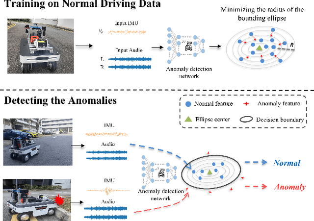
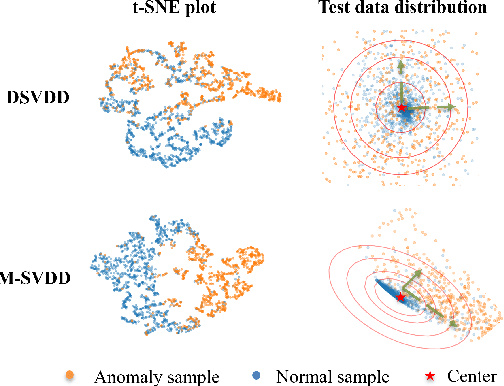
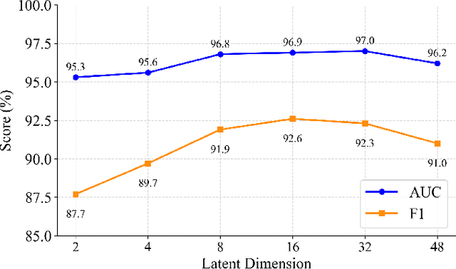
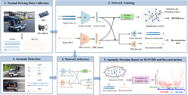
Reliable anomaly detection is essential for ensuring the safety of autonomous robots, particularly when conventional detection systems based on vision or LiDAR become unreliable in adverse or unpredictable conditions. In such scenarios, alternative sensing modalities are needed to provide timely and robust feedback. To this end, we explore the use of audio and inertial measurement unit (IMU) sensors to detect underlying anomalies in autonomous mobile robots, such as collisions and internal mechanical faults. Furthermore, to address the challenge of limited labeled anomaly data, we propose an unsupervised anomaly detection framework based on Mahalanobis Support Vector Data Description (M-SVDD). In contrast to conventional SVDD methods that rely on Euclidean distance and assume isotropic feature distributions, our approach employs the Mahalanobis distance to adaptively scale feature dimensions and capture inter-feature correlations, enabling more expressive decision boundaries. In addition, a reconstruction-based auxiliary branch is introduced to preserve feature diversity and prevent representation collapse, further enhancing the robustness of anomaly detection. Extensive experiments on a collected mobile robot dataset and four public datasets demonstrate the effectiveness of the proposed method, as shown in the video https://youtu.be/yh1tn6DDD4A. Code and dataset are available at https://github.com/jamesyang7/M-SVDD.