 Add to Chrome
 Add to Firefox
 Add to Edge
From Orthomosaics to Raw UAV Imagery: Enhancing Palm Detection and Crown-Center Localization
Sep 15, 2025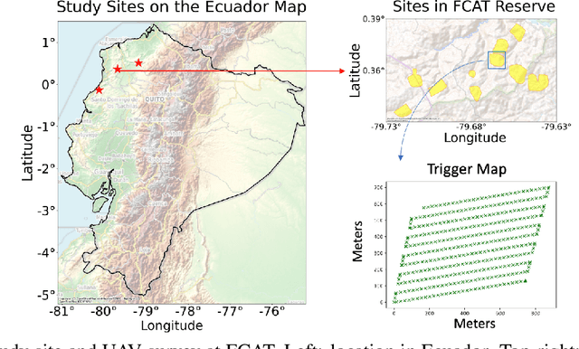
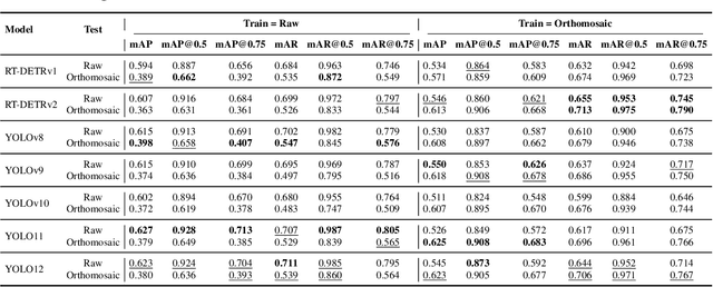
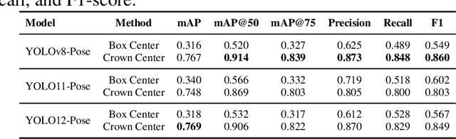
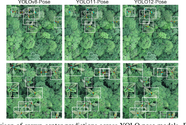
Accurate mapping of individual trees is essential for ecological monitoring and forest management. Orthomosaic imagery from unmanned aerial vehicles (UAVs) is widely used, but stitching artifacts and heavy preprocessing limit its suitability for field deployment. This study explores the use of raw UAV imagery for palm detection and crown-center localization in tropical forests. Two research questions are addressed: (1) how detection performance varies across orthomosaic and raw imagery, including within-domain and cross-domain transfer, and (2) to what extent crown-center annotations improve localization accuracy beyond bounding-box centroids. Using state-of-the-art detectors and keypoint models, we show that raw imagery yields superior performance in deployment-relevant scenarios, while orthomosaics retain value for robust cross-domain generalization. Incorporating crown-center annotations in training further improves localization and provides precise tree positions for downstream ecological analyses. These findings offer practical guidance for UAV-based biodiversity and conservation monitoring.
PalmProbNet: A Probabilistic Approach to Understanding Palm Distributions in Ecuadorian Tropical Forest via Transfer Learning
Mar 05, 2024Palms play an outsized role in tropical forests and are important resources for humans and wildlife. A central question in tropical ecosystems is understanding palm distribution and abundance. However, accurately identifying and localizing palms in geospatial imagery presents significant challenges due to dense vegetation, overlapping canopies, and variable lighting conditions in mixed-forest landscapes. Addressing this, we introduce PalmProbNet, a probabilistic approach utilizing transfer learning to analyze high-resolution UAV-derived orthomosaic imagery, enabling the detection of palm trees within the dense canopy of the Ecuadorian Rainforest. This approach represents a substantial advancement in automated palm detection, effectively pinpointing palm presence and locality in mixed tropical rainforests. Our process begins by generating an orthomosaic image from UAV images, from which we extract and label palm and non-palm image patches in two distinct sizes. These patches are then used to train models with an identical architecture, consisting of an unaltered pre-trained ResNet-18 and a Multilayer Perceptron (MLP) with specifically trained parameters. Subsequently, PalmProbNet employs a sliding window technique on the landscape orthomosaic, using both small and large window sizes to generate a probability heatmap. This heatmap effectively visualizes the distribution of palms, showcasing the scalability and adaptability of our approach in various forest densities. Despite the challenging terrain, our method demonstrated remarkable performance, achieving an accuracy of 97.32% and a Cohen's kappa of 94.59% in testing.