Sassan Saatchi
Capturing Temporal Dynamics in Large-Scale Canopy Tree Height Estimation
Jan 31, 2025


Abstract:With the rise in global greenhouse gas emissions, accurate large-scale tree canopy height maps are essential for understanding forest structure, estimating above-ground biomass, and monitoring ecological disruptions. To this end, we present a novel approach to generate large-scale, high-resolution canopy height maps over time. Our model accurately predicts canopy height over multiple years given Sentinel-2 time series satellite data. Using GEDI LiDAR data as the ground truth for training the model, we present the first 10m resolution temporal canopy height map of the European continent for the period 2019-2022. As part of this product, we also offer a detailed canopy height map for 2020, providing more precise estimates than previous studies. Our pipeline and the resulting temporal height map are publicly available, enabling comprehensive large-scale monitoring of forests and, hence, facilitating future research and ecological analyses. For an interactive viewer, see https://europetreemap.projects.earthengine.app/view/temporalcanopyheight.
High Resolution Tree Height Mapping of the Amazon Forest using Planet NICFI Images and LiDAR-Informed U-Net Model
Jan 17, 2025


Abstract:Tree canopy height is one of the most important indicators of forest biomass, productivity, and ecosystem structure, but it is challenging to measure accurately from the ground and from space. Here, we used a U-Net model adapted for regression to map the mean tree canopy height in the Amazon forest from Planet NICFI images at ~4.78 m spatial resolution for the period 2020-2024. The U-Net model was trained using canopy height models computed from aerial LiDAR data as a reference, along with their corresponding Planet NICFI images. Predictions of tree heights on the validation sample exhibited a mean error of 3.68 m and showed relatively low systematic bias across the entire range of tree heights present in the Amazon forest. Our model successfully estimated canopy heights up to 40-50 m without much saturation, outperforming existing canopy height products from global models in this region. We determined that the Amazon forest has an average canopy height of ~22 m. Events such as logging or deforestation could be detected from changes in tree height, and encouraging results were obtained to monitor the height of regenerating forests. These findings demonstrate the potential for large-scale mapping and monitoring of tree height for old and regenerating Amazon forests using Planet NICFI imagery.
Sentinel-1 SAR Based Weakly Supervised Learning For Tropical Forest Mapping
Aug 02, 2024


Abstract:Tropical forests play an important role in regulating the global carbon cycle and are crucial for maintaining the tropical forest biodiversity. Therefore, there is an urgent need to map the extent of tropical forest ecosystems. Recently, deep learning has come out as a powerful tool to map these ecosystems with the caveat of curating high quality reference datasets. Since, manually annotating high quality reference datasets is time consuming and expensive, weakly supervised learning techniques offer the potential to train high quality models without the need for manually annotating large quantities of reference datasets. In this manuscript, we propose two weakly supervised approaches that are based on Sentinel-1 SAR images, sparsely distributed pixel-wise high quality reference labels and densely distributed noisy reference labels. The proposed approaches were tested in a tropical setting in the Brazilian amazon. The results demonstrate that high quality tropical forest maps can be derived from weakly supervised learning without the need for manually annotated labels.
Estimating Canopy Height at Scale
Jun 03, 2024


Abstract:We propose a framework for global-scale canopy height estimation based on satellite data. Our model leverages advanced data preprocessing techniques, resorts to a novel loss function designed to counter geolocation inaccuracies inherent in the ground-truth height measurements, and employs data from the Shuttle Radar Topography Mission to effectively filter out erroneous labels in mountainous regions, enhancing the reliability of our predictions in those areas. A comparison between predictions and ground-truth labels yields an MAE / RMSE of 2.43 / 4.73 (meters) overall and 4.45 / 6.72 (meters) for trees taller than five meters, which depicts a substantial improvement compared to existing global-scale maps. The resulting height map as well as the underlying framework will facilitate and enhance ecological analyses at a global scale, including, but not limited to, large-scale forest and biomass monitoring.
Amazon's 2023 Drought: Sentinel-1 Reveals Extreme Rio Negro River Contraction
Jan 29, 2024Abstract:The Amazon, the world's largest rainforest, faces a severe historic drought. The Rio Negro River, one of the major Amazon River tributaries, reaches its lowest level in a century in October 2023. Here, we used a U-net deep learning model to map water surfaces in the Rio Negro River basin every 12 days in 2022 and 2023 using 10 m spatial resolution Sentinel-1 satellite radar images. The accuracy of the water surface model was high with an F1-score of 0.93. The 12 days mosaic time series of water surface was generated from the Sentinel-1 prediction. The water surface mask demonstrated relatively consistent agreement with the Global Surface Water (GSW) product from Joint Research Centre (F1-score: 0.708) and with the Brazilian Mapbiomas Water initiative (F1-score: 0.686). The main errors of the map were omission errors in flooded woodland, in flooded shrub and because of clouds. Rio Negro water surfaces reached their lowest level around the 25th of November 2023 and were reduced to 68.1\% (9,559.9 km$^2$) of the maximum water surfaces observed in the period 2022-2023 (14,036.3 km$^2$). Synthetic Aperture Radar (SAR) data, in conjunction with deep learning techniques, can significantly improve near real-time mapping of water surface in tropical regions.
Sub-Meter Tree Height Mapping of California using Aerial Images and LiDAR-Informed U-Net Model
Jun 02, 2023


Abstract:Tree canopy height is one of the most important indicators of forest biomass, productivity, and species diversity, but it is challenging to measure accurately from the ground and from space. Here, we used a U-Net model adapted for regression to map the canopy height of all trees in the state of California with very high-resolution aerial imagery (60 cm) from the USDA-NAIP program. The U-Net model was trained using canopy height models computed from aerial LiDAR data as a reference, along with corresponding RGB-NIR NAIP images collected in 2020. We evaluated the performance of the deep-learning model using 42 independent 1 km$^2$ sites across various forest types and landscape variations in California. Our predictions of tree heights exhibited a mean error of 2.9 m and showed relatively low systematic bias across the entire range of tree heights present in California. In 2020, trees taller than 5 m covered ~ 19.3% of California. Our model successfully estimated canopy heights up to 50 m without saturation, outperforming existing canopy height products from global models. The approach we used allowed for the reconstruction of the three-dimensional structure of individual trees as observed from nadir-looking optical airborne imagery, suggesting a relatively robust estimation and mapping capability, even in the presence of image distortion. These findings demonstrate the potential of large-scale mapping and monitoring of tree height, as well as potential biomass estimation, using NAIP imagery.
Vision Transformers, a new approach for high-resolution and large-scale mapping of canopy heights
Apr 22, 2023


Abstract:Accurate and timely monitoring of forest canopy heights is critical for assessing forest dynamics, biodiversity, carbon sequestration as well as forest degradation and deforestation. Recent advances in deep learning techniques, coupled with the vast amount of spaceborne remote sensing data offer an unprecedented opportunity to map canopy height at high spatial and temporal resolutions. Current techniques for wall-to-wall canopy height mapping correlate remotely sensed 2D information from optical and radar sensors to the vertical structure of trees using LiDAR measurements. While studies using deep learning algorithms have shown promising performances for the accurate mapping of canopy heights, they have limitations due to the type of architectures and loss functions employed. Moreover, mapping canopy heights over tropical forests remains poorly studied, and the accurate height estimation of tall canopies is a challenge due to signal saturation from optical and radar sensors, persistent cloud covers and sometimes the limited penetration capabilities of LiDARs. Here, we map heights at 10 m resolution across the diverse landscape of Ghana with a new vision transformer (ViT) model optimized concurrently with a classification (discrete) and a regression (continuous) loss function. This model achieves better accuracy than previously used convolutional based approaches (ConvNets) optimized with only a continuous loss function. The ViT model results show that our proposed discrete/continuous loss significantly increases the sensitivity for very tall trees (i.e., > 35m), for which other approaches show saturation effects. The height maps generated by the ViT also have better ground sampling distance and better sensitivity to sparse vegetation in comparison to a convolutional model. Our ViT model has a RMSE of 3.12m in comparison to a reference dataset while the ConvNet model has a RMSE of 4.3m.
Mapping Tropical Forest Cover and Deforestation with Planet NICFI Satellite Images and Deep Learning in Mato Grosso State (Brazil) from 2015 to 2021
Nov 17, 2022


Abstract:Monitoring changes in tree cover for rapid assessment of deforestation is considered the critical component of any climate mitigation policy for reducing carbon. Here, we map tropical tree cover and deforestation between 2015 and 2022 using 5 m spatial resolution Planet NICFI satellite images over the state of Mato Grosso (MT) in Brazil and a U-net deep learning model. The tree cover for the state was 556510.8 km$^2$ in 2015 (58.1 % of the MT State) and was reduced to 141598.5 km$^2$ (14.8 % of total area) at the end of 2021. After reaching a minimum deforested area in December 2016 with 6632.05 km$^2$, the bi-annual deforestation area only showed a slight increase between December 2016 and December 2019. A year after, the areas of deforestation almost doubled from 9944.5 km$^2$ in December 2019 to 19817.8 km$^2$ in December 2021. The high-resolution data product showed relatively consistent agreement with the official deforestation map from Brazil (67.2%) but deviated significantly from year of forest cover loss estimates from the Global Forest change (GFC) product, mainly due to large area of fire degradation observed in the GFC data. High-resolution imagery from Planet NICFI associated with deep learning technics can significantly improve mapping deforestation extent in tropics.
K-textures, a self supervised hard clustering deep learning algorithm for satellite images segmentation
May 18, 2022


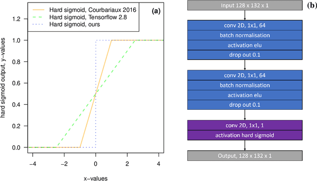
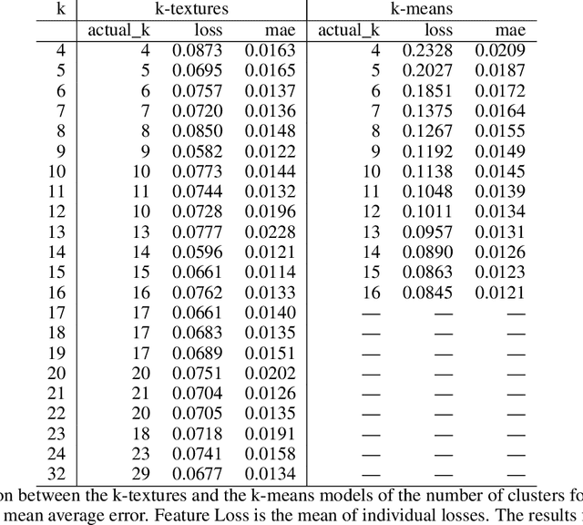
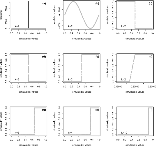
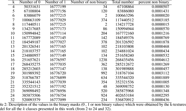
Abstract:Deep learning self supervised algorithms that can segment an image in a fixed number of hard labels such as the k-means algorithm and only relying only on deep learning techniques are still lacking. Here, we introduce the k-textures algorithm which provides self supervised segmentation of a 4-band image (RGB-NIR) for a $k$ number of classes. An example of its application on high resolution Planet satellite imagery is given. Our algorithm shows that discrete search is feasible using convolutional neural networks (CNN) and gradient descent. The model detects $k$ hard clustering classes represented in the model as $k$ discrete binary masks and their associated $k$ independently generated textures, that combined are a simulation of the original image. The similarity loss is the mean squared error between the features of the original and the simulated image, both extracted from the penultimate convolutional block of Keras 'imagenet' pretrained VGG-16 model and a custom feature extractor made with Planet data. The main advances of the k-textures model are: first, the $k$ discrete binary masks are obtained inside the model using gradient descent. The model allows for the generation of discrete binary masks using a novel method using a hard sigmoid activation function. Second, it provides hard clustering classes -- each pixels has only one class. Finally, in comparison to k-means, where each pixel is considered independently, here, contextual information is also considered and each class is not associated only to a similar values in the color channels but to a texture. Our approach is designed to ease the production of training samples for satellite image segmentation. The model codes and weights are available at https://doi.org/10.5281/zenodo.6359859
 Add to Chrome
 Add to Firefox
 Add to Edge