 Add to Chrome
 Add to Firefox
 Add to Edge
TrajMoE: Spatially-Aware Mixture of Experts for Unified Human Mobility Modeling
May 24, 2025Modeling human mobility across diverse cities is essential for applications such as urban planning, transportation optimization, and personalized services. However, generalization remains challenging due to heterogeneous spatial representations and mobility patterns across cities. Existing methods typically rely on numerical coordinates or require training city-specific models, limiting their scalability and transferability. We propose TrajMoE, a unified and scalable model for cross-city human mobility modeling. TrajMoE addresses two key challenges: (1) inconsistent spatial semantics across cities, and (2) diverse urban mobility patterns. To tackle these, we begin by designing a spatial semantic encoder that learns transferable location representations from POI-based functional semantics and visit patterns. Furthermore, we design a Spatially-Aware Mixture-of-Experts (SAMoE) Transformer that injects structured priors into experts specialized in distinct mobility semantics, along with a shared expert to capture city-invariant patterns and enable adaptive cross-city generalization. Extensive experiments demonstrate that TrajMoE achieves up to 27% relative improvement over competitive mobility foundation models after only one epoch of fine-tuning, and consistently outperforms full-data baselines using merely 5% of target city data. These results establish TrajMoE as a significant step toward realizing a truly generalizable, transferable, and pretrainable foundation model for human mobility.
FGSD: A Dataset for Fine-Grained Ship Detection in High Resolution Satellite Images
Mar 15, 2020
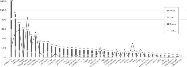
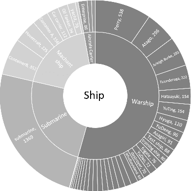
Ship detection using high-resolution remote sensing images is an important task, which contribute to sea surface regulation. The complex background and special visual angle make ship detection relies in high quality datasets to a certain extent. However, there is few works on giving both precise classification and accurate location of ships in existing ship detection datasets. To further promote the research of ship detection, we introduced a new fine-grained ship detection datasets, which is named as FGSD. The dataset collects high-resolution remote sensing images that containing ship samples from multiple large ports around the world. Ship samples were fine categorized and annotated with both horizontal and rotating bounding boxes. To further detailed the information of the dataset, we put forward a new representation method of ships' orientation. For future research, the dock as a new class was annotated in the dataset. Besides, rich information of images were provided in FGSD, including the source port, resolution and corresponding GoogleEarth' s resolution level of each image. As far as we know, FGSD is the most comprehensive ship detection dataset currently and it'll be available soon. Some baselines for FGSD are also provided in this paper.