 Add to Chrome
 Add to Firefox
 Add to Edge
Driving with DINO: Vision Foundation Features as a Unified Bridge for Sim-to-Real Generation in Autonomous Driving
Feb 09, 2026Driven by the emergence of Controllable Video Diffusion, existing Sim2Real methods for autonomous driving video generation typically rely on explicit intermediate representations to bridge the domain gap. However, these modalities face a fundamental Consistency-Realism Dilemma. Low-level signals (e.g., edges, blurred images) ensure precise control but compromise realism by "baking in" synthetic artifacts, whereas high-level priors (e.g., depth, semantics, HDMaps) facilitate photorealism but lack the structural detail required for consistent guidance. In this work, we present Driving with DINO (DwD), a novel framework that leverages Vision Foundation Module (VFM) features as a unified bridge between the simulation and real-world domains. We first identify that these features encode a spectrum of information, from high-level semantics to fine-grained structure. To effectively utilize this, we employ Principal Subspace Projection to discard the high-frequency elements responsible for "texture baking," while concurrently introducing Random Channel Tail Drop to mitigate the structural loss inherent in rigid dimensionality reduction, thereby reconciling realism with control consistency. Furthermore, to fully leverage DINOv3's high-resolution capabilities for enhancing control precision, we introduce a learnable Spatial Alignment Module that adapts these high-resolution features to the diffusion backbone. Finally, we propose a Causal Temporal Aggregator employing causal convolutions to explicitly preserve historical motion context when integrating frame-wise DINO features, which effectively mitigates motion blur and guarantees temporal stability. Project page: https://albertchen98.github.io/DwD-project/
MeSS: City Mesh-Guided Outdoor Scene Generation with Cross-View Consistent Diffusion
Aug 21, 2025Mesh models have become increasingly accessible for numerous cities; however, the lack of realistic textures restricts their application in virtual urban navigation and autonomous driving. To address this, this paper proposes MeSS (Meshbased Scene Synthesis) for generating high-quality, styleconsistent outdoor scenes with city mesh models serving as the geometric prior. While image and video diffusion models can leverage spatial layouts (such as depth maps or HD maps) as control conditions to generate street-level perspective views, they are not directly applicable to 3D scene generation. Video diffusion models excel at synthesizing consistent view sequences that depict scenes but often struggle to adhere to predefined camera paths or align accurately with rendered control videos. In contrast, image diffusion models, though unable to guarantee cross-view visual consistency, can produce more geometry-aligned results when combined with ControlNet. Building on this insight, our approach enhances image diffusion models by improving cross-view consistency. The pipeline comprises three key stages: first, we generate geometrically consistent sparse views using Cascaded Outpainting ControlNets; second, we propagate denser intermediate views via a component dubbed AGInpaint; and third, we globally eliminate visual inconsistencies (e.g., varying exposure) using the GCAlign module. Concurrently with generation, a 3D Gaussian Splatting (3DGS) scene is reconstructed by initializing Gaussian balls on the mesh surface. Our method outperforms existing approaches in both geometric alignment and generation quality. Once synthesized, the scene can be rendered in diverse styles through relighting and style transfer techniques.
Primitive Graph Learning for Unified Vector Mapping
Jun 28, 2022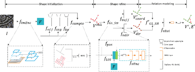
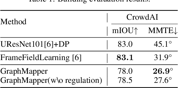
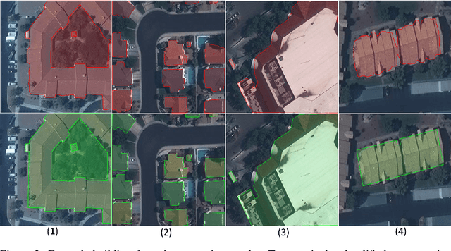

Large-scale vector mapping is important for transportation, city planning, and survey and census. We propose GraphMapper, a unified framework for end-to-end vector map extraction from satellite images. Our key idea is a novel unified representation of shapes of different topologies named "primitive graph", which is a set of shape primitives and their pairwise relationship matrix. Then, we convert vector shape prediction, regularization, and topology reconstruction into a unique primitive graph learning problem. Specifically, GraphMapper is a generic primitive graph learning network based on global shape context modelling through multi-head-attention. An embedding space sorting method is developed for accurate primitive relationship modelling. We empirically demonstrate the effectiveness of GraphMapper on two challenging mapping tasks, building footprint regularization and road network topology reconstruction. Our model outperforms state-of-the-art methods by 8-10% in both tasks on public benchmarks. All code will be publicly available.