 Add to Chrome
 Add to Firefox
 Add to Edge
Does Latent Context Help? A Controlled Evaluation of Inverse Reinforcement Learning in Arctic Shipping
Aug 06, 2026
Artificial Intelligence (AI)-assisted navigation can help Arctic shipping adapt to rapidly changing sea-ice conditions, but reliable deployment requires reward models that are interpretable and robust to changing environments. Inverse reinforcement learning (IRL) provides a framework for recovering such rewards from vessel trajectories, while recent meta-IRL methods introduce latent context variables to capture behavioral heterogeneity. However, it remains unclear whether these latent representations recover genuinely hidden preferences or simply re-encode information already available in the observed state. We conduct a controlled evaluation on 3,186 AIS-derived voyages from 202 vessels across nine Arctic shipping seasons, comparing a linear shared reward, a nonlinear shared reward, and a latent-context model built on the same nonlinear architecture. The nonlinear reward improves held-out likelihood by 50.9% over the linear baseline, whereas adding vessel-specific latent context reduces performance by 16.5%. Behavioral analysis, context probes, and a pre-registered feature-hiding ablation show that apparent vessel-level variation is largely explained by observable route and environmental conditions rather than hidden vessel-specific factors. Moreover, predictive accuracy, route fidelity, and reward transfer yield different model rankings, demonstrating that no single metric is sufficient to evaluate learned rewards. These findings motivate testing whether the observed route, environmental, and vessel features already explain behavioral variation before adding per-vessel latent context. This supports more trustworthy AI deployment in safety-critical domains.

Transferable Dual-Stream Representations for Mesoscale-Preserving Sea Surface Temperature Downscaling
Aug 04, 2026Deep learning models for scientific spatio-temporal downscaling often minimize reconstruction error while failing to preserve physically meaningful multi-scale structure. For sea surface temperature prediction, this can yield outputs that are numerically plausible yet overly smooth, missing mesoscale variability critical to regional ocean dynamics. Existing methods often focus on pixel-wise objectives or single-context conditioning, which limits their ability to preserve spectral fidelity and generalize across regions. To address this, we propose EddyFlow, a representation learning framework for kilometer-scale sea surface temperature downscaling that balances predictive accuracy, scale-dependent structure, and regional generalization. EddyFlow is trained on the Gulf of St.~Lawrence and evaluated in zero-shot and few-shot settings on the Bay of Fundy and the Gulf of Mexico. EddyFlow demonstrates that physics-informed representation learning reduces zero-shot RMSE by 21%, achieves up to 85.6% skill relative to persistence on unseen domains, and maintains near-ideal spectral fidelity with a PSD ratio of $\approx 1.00$.
Covariance Last-Layer Ensembles: Function-Space Diversity for Efficient Uncertainty Quantification
Jul 26, 2026A Last-Layer Ensemble (LLE), $K$ linear units on one shared frozen feature map, is an efficient single-pass approach to the disagreement-based epistemic uncertainty for out-of-distribution (OOD) detection. Its weakness is that members share the backbone gradient and can converge toward the same function, collapsing the inter-member diversity the signal depends on. Whether last-layer diversity can be restored, and what mitigates the collapse, is an open question. The weight-orthonormality defining Orthonormal Certificates (OC), the weight-orthonormal special case of the LLE, is only an indirect correction; it decorrelates the weights of the members, not their predictions. Here, we instead target the collapse directly in function space, with a Covariance Last-Layer Ensemble (cov-LLE) that places a direct covariance penalty on member activations. Cov-LLE restores the function-space diversity that weight-orthonormality cannot, and at matched $K$ recovers much of the diversity and calibration of a deep ensemble at $1\times$ backbone cost (in-distribution prediction variance $0.05\!\to\!9.3$ vs.\ $22.1$ ($\times10^{-3}$), and ECE $0.135\!\to\!0.090$ vs.\ $0.035$, for a $K\times$-cost deep ensemble), at no cost to accuracy. Viewing OC as a last-layer ensemble also organizes detectors into a two-axis taxonomy (by how their units are trained and how their outputs are scored) and exposes the OC score as a magnitude, motivating a scale-invariant, label-free direction score that repairs its near-OOD failure, adding $+0.16$ to $+0.18$ ROC AUC on every backbone.
MoCo-AIS: A Contrastive Learning Framework for Similarity Computation of Vessel Trajectories
Jun 16, 2026Trajectory similarity is a fundamental task in analyzing mobility patterns, essential for applications such as route pattern extraction, mobility prediction, and anomaly detection. Traditional distance-based measures for computing similarity incur high computational cost, driving the adoption of lightweight learning-based approaches. Supervised methods rely on extensive labels derived from traditional distance measures and often reproduce these metrics, which limits generalization. While self-supervised learning addresses this issue through contrastive learning, it lacks a unified framework, making it difficult to compare deep learning (DL) models for consistent trajectory representation. Accordingly, this paper presents MoCo-AIS, a unified framework for learning vessel trajectory embeddings based on the Momentum Contrast (MoCo) paradigm, which formulates similarity learning through positive and negative trajectory pairs. Within this framework, we evaluate a diverse set of leading DL models on large-scale, real-world vessel-tracking AIS datasets that capture diverse navigation behaviors and operating conditions. Results demonstrate that our framework significantly improves similarity learning over existing baselines, while providing a benchmarking platform for evaluating trajectory representation models.
A Theoretical Framework for Environmental Similarity and Vessel Mobility as Coupled Predictors of Marine Invasive Species Pathways
Nov 05, 2025Marine invasive species spread through global shipping and generate substantial ecological and economic impacts. Traditional risk assessments require detailed records of ballast water and traffic patterns, which are often incomplete, limiting global coverage. This work advances a theoretical framework that quantifies invasion risk by combining environmental similarity across ports with observed and forecasted maritime mobility. Climate-based feature representations characterize each port's marine conditions, while mobility networks derived from Automatic Identification System data capture vessel flows and potential transfer pathways. Clustering and metric learning reveal climate analogues and enable the estimation of species survival likelihood along shipping routes. A temporal link prediction model captures how traffic patterns may change under shifting environmental conditions. The resulting fusion of environmental similarity and predicted mobility provides exposure estimates at the port and voyage levels, supporting targeted monitoring, routing adjustments, and management interventions.
Gravity-Informed Deep Learning Framework for Predicting Ship Traffic Flow and Invasion Risk of Non-Indigenous Species via Ballast Water Discharge
Jan 29, 2024Invasive species in water bodies pose a major threat to the environment and biodiversity globally. Due to increased transportation and trade, non-native species have been introduced to new environments, causing damage to ecosystems and leading to economic losses in agriculture, forestry, and fisheries. Therefore, there is a pressing need for risk assessment and management techniques to mitigate the impact of these invasions. This study aims to develop a new physics-inspired model to forecast maritime shipping traffic and thus inform risk assessment of invasive species spread through global transportation networks. Inspired by the gravity model for international trades, our model considers various factors that influence the likelihood and impact of vessel activities, such as shipping flux density, distance between ports, trade flow, and centrality measures of transportation hubs. Additionally, by analyzing the risk network of invasive species, we provide a comprehensive framework for assessing the invasion threat level given a pair of origin and destination. Accordingly, this paper introduces transformers to gravity models to rebuild the short- and long-term dependencies that make the risk analysis feasible. Thus, we introduce a physics-inspired framework that achieves an 89% segmentation accuracy for existing and non-existing trajectories and an 84.8% accuracy for the number of vessels flowing between key port areas, representing more than 10% improvement over the traditional deep-gravity model. Along these lines, this research contributes to a better understanding of invasive species risk assessment. It allows policymakers, conservationists, and stakeholders to prioritize management actions by identifying high-risk invasion pathways. Besides, our model is versatile and can include new data sources, making it suitable for assessing species invasion risks in a changing global landscape.
Building a Safer Maritime Environment Through Multi-Path Long-Term Vessel Trajectory Forecasting
Oct 29, 2023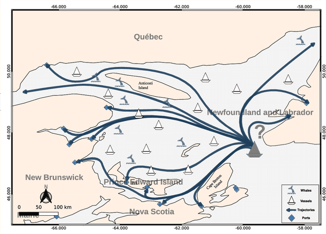

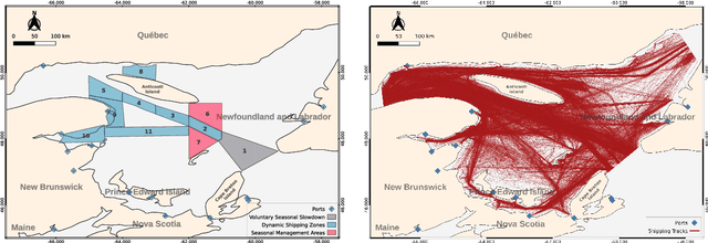

Maritime transport is paramount to global economic growth and environmental sustainability. In this regard, the Automatic Identification System (AIS) data plays a significant role by offering real-time streaming data on vessel movement, which allows for enhanced traffic surveillance, assisting in vessel safety by avoiding vessel-to-vessel collisions and proactively preventing vessel-to-whale ones. This paper tackles an intrinsic problem to trajectory forecasting: the effective multi-path long-term vessel trajectory forecasting on engineered sequences of AIS data. We utilize an encoder-decoder model with Bidirectional Long Short-Term Memory Networks (Bi-LSTM) to predict the next 12 hours of vessel trajectories using 1 to 3 hours of AIS data. We feed the model with probabilistic features engineered from the AIS data that refer to the potential route and destination of each trajectory so that the model, leveraging convolutional layers for spatial feature learning and a position-aware attention mechanism that increases the importance of recent timesteps of a sequence during temporal feature learning, forecasts the vessel trajectory taking the potential route and destination into account. The F1 Score of these features is approximately 85% and 75%, indicating their efficiency in supplementing the neural network. We trialed our model in the Gulf of St. Lawrence, one of the North Atlantic Right Whales (NARW) habitats, achieving an R2 score exceeding 98% with varying techniques and features. Despite the high R2 score being attributed to well-defined shipping lanes, our model demonstrates superior complex decision-making during path selection. In addition, our model shows enhanced accuracy, with average and median forecasting errors of 11km and 6km, respectively. Our study confirms the potential of geographical data engineering and trajectory forecasting models for preserving marine life species.
A semi-supervised geometric-driven methodology for supervised fishing activity detection on multi-source AIS tracking messages
Jul 12, 2022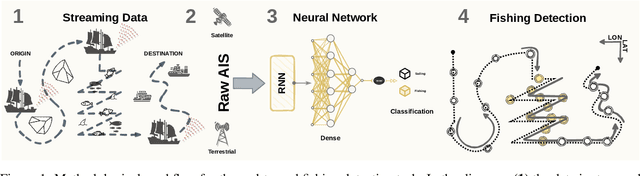
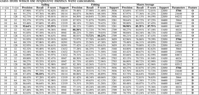
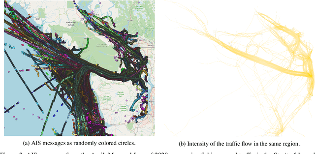

Automatic Identification System (AIS) messages are useful for tracking vessel activity across oceans worldwide using radio links and satellite transceivers. Such data plays a significant role in tracking vessel activity and mapping mobility patterns such as those found in fishing. Accordingly, this paper proposes a geometric-driven semi-supervised approach for fishing activity detection from AIS data. Through the proposed methodology we show how to explore the information included in the messages to extract features describing the geometry of the vessel route. To this end, we leverage the unsupervised nature of cluster analysis to label the trajectory geometry highlighting the changes in the vessel's moving pattern which tends to indicate fishing activity. The labels obtained by the proposed unsupervised approach are used to detect fishing activities, which we approach as a time-series classification task. In this context, we propose a solution using recurrent neural networks on AIS data streams with roughly 87% of the overall $F$-score on the whole trajectories of 50 different unseen fishing vessels. Such results are accompanied by a broad benchmark study assessing the performance of different Recurrent Neural Network (RNN) architectures. In conclusion, this work contributes by proposing a thorough process that includes data preparation, labeling, data modeling, and model validation. Therefore, we present a novel solution for mobility pattern detection that relies upon unfolding the trajectory in time and observing their inherent geometry.
From Cities to Series: Complex Networks and Deep Learning for Improved Spatial and Temporal Analytics*
Jun 01, 2022Graphs have often been used to answer questions about the interaction between real-world entities by taking advantage of their capacity to represent complex topologies. Complex networks are known to be graphs that capture such non-trivial topologies; they are able to represent human phenomena such as epidemic processes, the dynamics of populations, and the urbanization of cities. The investigation of complex networks has been extrapolated to many fields of science, with particular emphasis on computing techniques, including artificial intelligence. In such a case, the analysis of the interaction between entities of interest is transposed to the internal learning of algorithms, a paradigm whose investigation is able to expand the state of the art in Computer Science. By exploring this paradigm, this thesis puts together complex networks and machine learning techniques to improve the understanding of the human phenomena observed in pandemics, pendular migration, and street networks. Accordingly, we contribute with: (i) a new neural network architecture capable of modeling dynamic processes observed in spatial and temporal data with applications in epidemics propagation, weather forecasting, and patient monitoring in intensive care units; (ii) a machine-learning methodology for analyzing and predicting links in the scope of human mobility between all the cities of Brazil; and, (iii) techniques for identifying inconsistencies in the urban planning of cities while tracking the most influential vertices, with applications over Brazilian and worldwide cities. We obtained results sustained by sound evidence of advances to the state of the art in artificial intelligence, rigorous formalisms, and ample experimentation. Our findings rely upon real-world applications in a range of domains, demonstrating the applicability of our methodologies.
Unfolding collective AIS transmission behavior for vessel movement modeling on irregular timing data using noise-robust neural networks
Feb 24, 2022
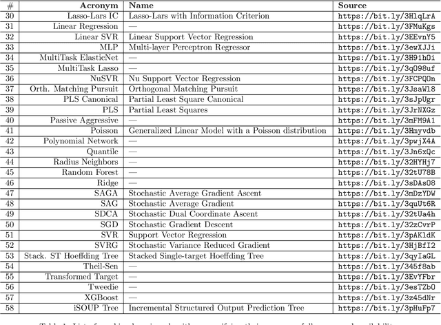
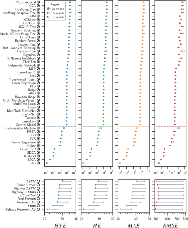
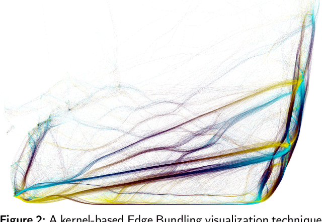
This paper aims to model the Automatic Identification System (AIS) message transmission behavior through neural networks for forecasting the upcoming AIS messages' content for multiple vessels simultaneously in the face of messages' irregular timing. We present a set of experiments comprising tens of algorithms used for forecasting tasks with horizon sizes of varying lengths. Deep learning models revealed themselves to adequately capture the temporal irregularity while preserving the spatial awareness of different vessels. We show how a multi-directional and multi-layer long-short-term memory network and a convolution feature-extraction layer improve such a task by up to 20.01%.