 Add to Chrome
 Add to Firefox
 Add to Edge
MoCo-AIS: A Contrastive Learning Framework for Similarity Computation of Vessel Trajectories
Jun 16, 2026Trajectory similarity is a fundamental task in analyzing mobility patterns, essential for applications such as route pattern extraction, mobility prediction, and anomaly detection. Traditional distance-based measures for computing similarity incur high computational cost, driving the adoption of lightweight learning-based approaches. Supervised methods rely on extensive labels derived from traditional distance measures and often reproduce these metrics, which limits generalization. While self-supervised learning addresses this issue through contrastive learning, it lacks a unified framework, making it difficult to compare deep learning (DL) models for consistent trajectory representation. Accordingly, this paper presents MoCo-AIS, a unified framework for learning vessel trajectory embeddings based on the Momentum Contrast (MoCo) paradigm, which formulates similarity learning through positive and negative trajectory pairs. Within this framework, we evaluate a diverse set of leading DL models on large-scale, real-world vessel-tracking AIS datasets that capture diverse navigation behaviors and operating conditions. Results demonstrate that our framework significantly improves similarity learning over existing baselines, while providing a benchmarking platform for evaluating trajectory representation models.
Learning to Weigh Waste: A Physics-Informed Multimodal Fusion Framework and Large-Scale Dataset for Commercial and Industrial Applications
Mar 03, 2026Accurate weight estimation of commercial and industrial waste is important for efficient operations, yet image-based estimation remains difficult because similar-looking objects may have different densities, and the visible size changes with camera distance. Addressing this problem, we propose Multimodal Weight Predictor (MWP) framework that estimates waste weight by combining RGB images with physics-informed metadata, including object dimensions, camera distance, and camera height. We also introduce Waste-Weight-10K, a real-world dataset containing 10,421 synchronized image-metadata collected from logistics and recycling sites. The dataset covers 11 waste categories and a wide weight range from 3.5 to 3,450 kg. Our model uses a Vision Transformer for visual features and a dedicated metadata encoder for geometric and category information, combining them with Stacked Mutual Attention Fusion that allows visual and physical cues guide each other. This helps the model manage perspective effects and link objects to material properties. To ensure stable performance across the wide weight range, we train the model using Mean Squared Logarithmic Error. On the test set, the proposed method achieves 88.06 kg Mean Absolute Error (MAE), 6.39% Mean Absolute Percentage Error (MAPE), and an R2 coefficient of 0.9548. The model shows strong accuracy for light objects in the 0-100 kg range with 2.38 kg MAE and 3.1% MAPE, maintaining reliable performance for heavy waste in the 1000-2000 kg range with 11.1% MAPE. Finally, we incorporate a physically grounded explanation module using Shapley Additive Explanations (SHAP) and a large language model to provide clear, human-readable explanations for each prediction.
A Survey on Spatio-temporal Data Analytics Systems
Mar 17, 2021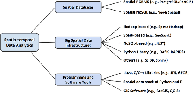


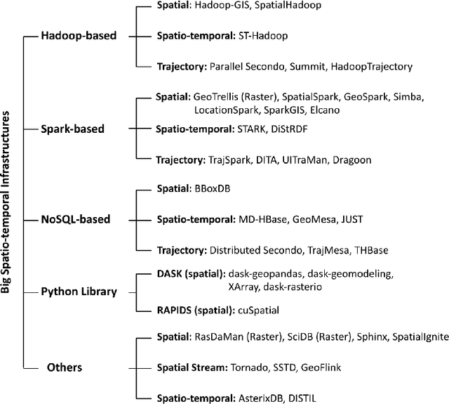
Due to the surge of spatio-temporal data volume, the popularity of location-based services and applications, and the importance of extracted knowledge from spatio-temporal data to solve a wide range of real-world problems, a plethora of research and development work has been done in the area of spatial and spatio-temporal data analytics in the past decade. The main goal of existing works was to develop algorithms and technologies to capture, store, manage, analyze, and visualize spatial or spatio-temporal data. The researchers have contributed either by adding spatio-temporal support with existing systems, by developing a new system from scratch for processing spatio-temporal data, or by implementing algorithms for mining spatio-temporal data. The existing ecosystem of spatial and spatio-temporal data analytics can be categorized into three groups, (1) spatial databases (SQL and NoSQL), (2) big spatio-temporal data processing infrastructures, and (3) programming languages and software tools for processing spatio-temporal data. Since existing surveys mostly investigated big data infrastructures for processing spatial data, this survey has explored the whole ecosystem of spatial and spatio-temporal analytics along with an up-to-date review of big spatial data processing systems. This survey also portrays the importance and future of spatial and spatio-temporal data analytics.