 Add to Chrome
 Add to Firefox
 Add to Edge
DigiForest: Digital Analytics and Robotics for Sustainable Forestry
Apr 16, 2026Covering one third of Earth's land surface, forests are vital to global biodiversity, climate regulation, and human well-being. In Europe, forests and woodlands reach approximately 40% of land area, and the forestry sector is central to achieving the EU's climate neutrality and biodiversity goals; these emphasize sustainable forest management, increased use of long-lived wood products, and resilient forest ecosystems. To meet these goals and properly address their inherent challenges, current practices require further innovation. This chapter introduces DigiForest, a novel, large-scale precision forestry approach leveraging digital technologies and autonomous robotics. DigiForest is structured around four main components: (1) autonomous, heterogeneous mobile robots (aerial, legged, and marsupial) for tree-level data collection; (2) automated extraction of tree traits to build forest inventories; (3) a Decision Support System (DSS) for forecasting forest growth and supporting decision-making; and (4) low-impact selective logging using purpose-built autonomous harvesters. These technologies have been extensively validated in real-world conditions in several locations, including forests in Finland, the UK, and Switzerland.
A multi-platform LiDAR dataset for standardized forest inventory measurement at long term ecological monitoring sites
Apr 16, 2026We present a curated multi-platform LiDAR reference dataset from an instrumented ICOS forest plot, explicitly designed to support calibration, benchmarking, and integration of 3D structural data with ecological observations and standard allometric models. The dataset integrates UAV-borne laser scanning (ULS) to measure canopy coverage, terrestrial laser scanning (TLS) for detailed stem mapping, and backpack mobile laser scanning (MLS) with real-time SLAM for efficient sub-canopy acquisition. We focus on the control plot with the most complete and internally consistent registration, where TLS point clouds (~333 million points) are complemented by ULS and MLS data capturing canopy and understory strata. Marker-free, SLAM-aware protocols were used to reduce field and processing time, while manual and automated methods were combined. Final products are available in LAZ and E57 formats with UTM coordinates, together with registration reports for reproducibility. The dataset provides a benchmark for testing registration methods, evaluating scanning efficiency, and linking point clouds with segmentation, quantitative structure models, and allometric biomass estimation. By situating the acquisitions at a long-term ICOS site, it is explicitly linked to 3D structure with decades of ecological and flux measurements. More broadly, it illustrates how TLS, MLS, and ULS can be combined for repeated inventories and digital twins of forest ecosystems.
Benchmarking tree species classification from proximally-sensed laser scanning data: introducing the FOR-species20K dataset
Aug 12, 2024Proximally-sensed laser scanning offers significant potential for automated forest data capture, but challenges remain in automatically identifying tree species without additional ground data. Deep learning (DL) shows promise for automation, yet progress is slowed by the lack of large, diverse, openly available labeled datasets of single tree point clouds. This has impacted the robustness of DL models and the ability to establish best practices for species classification. To overcome these challenges, the FOR-species20K benchmark dataset was created, comprising over 20,000 tree point clouds from 33 species, captured using terrestrial (TLS), mobile (MLS), and drone laser scanning (ULS) across various European forests, with some data from other regions. This dataset enables the benchmarking of DL models for tree species classification, including both point cloud-based (PointNet++, MinkNet, MLP-Mixer, DGCNNs) and multi-view image-based methods (SimpleView, DetailView, YOLOv5). 2D image-based models generally performed better (average OA = 0.77) than 3D point cloud-based models (average OA = 0.72), with consistent results across different scanning platforms and sensors. The top model, DetailView, was particularly robust, handling data imbalances well and generalizing effectively across tree sizes. The FOR-species20K dataset, available at https://zenodo.org/records/13255198, is a key resource for developing and benchmarking DL models for tree species classification using laser scanning data, providing a foundation for future advancements in the field.
Linking Sap Flow Measurements with Earth Observations
Aug 03, 2021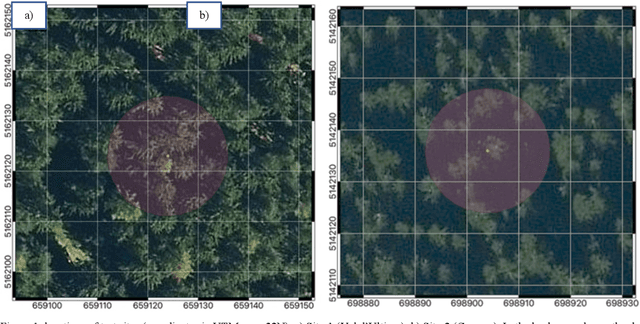
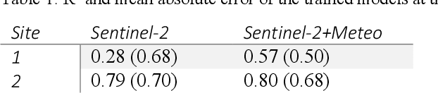
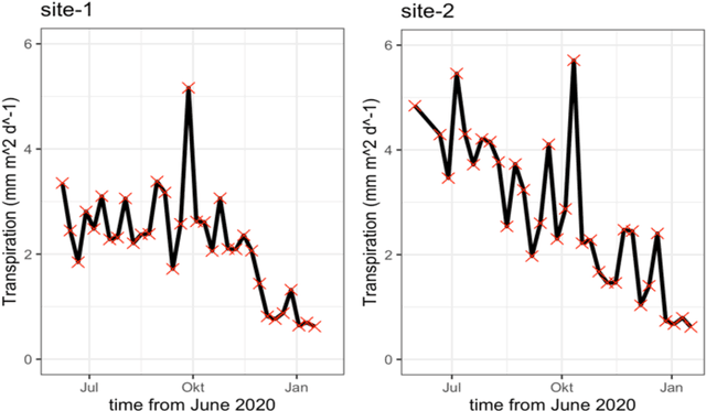
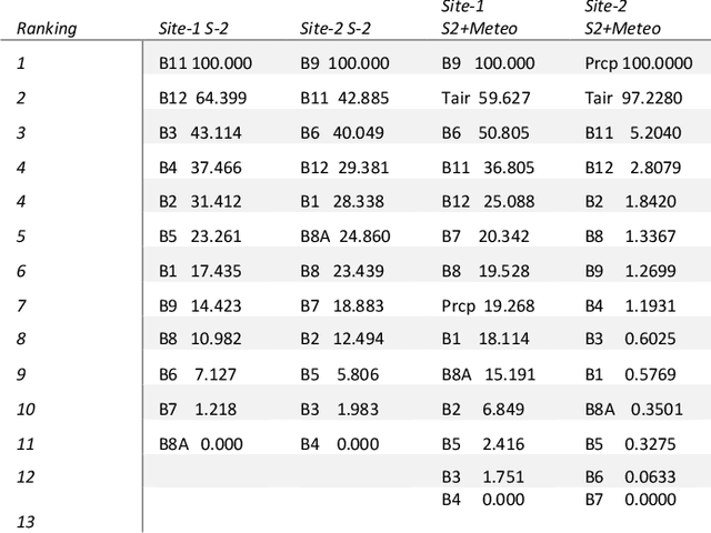
While single-tree transpiration is challenging to compare with earth observation, canopy scale data are suitable for this purpose. To test the potentialities of the second approach, we equipped the trees at two measurement sites with sap flow sensors in spruce forests. The sites have contrasting topography. The measurement period covered the months between June 2020 and January 2021. To link plot scale transpiration with earth observations, we utilized Sentinel-2 and local meteorological data. Within a machine learning framework, we have tested the suitability of earth observations for modelling canopy transpiration. The R2 of the cross-validated trained models at the measurement sites was between 0.57 and 0.80. These results demonstrate the relevance of Sentinel-2 data for the data-driven upscaling of ecosystem fluxes from plot scale sap flow data. If applied to a broader network of sites and climatic conditions, such an approach could offer unprecedented possibilities for investigating our forests' resilience and resistance capacity to an intensified hydrological cycle in the contest of a changing climate.