 Add to Chrome
 Add to Firefox
 Add to Edge
BathyFacto: Refraction-Aware Two-Media Neural Radiance Fields for Bathymetry
May 11, 2026
Through-water photogrammetry based on UAV imagery enables shallow-water bathymetry, but refraction at the air-water interface violates the straight-ray assumption of Structure-from-Motion and causes systematic depth bias. We present BathyFacto, a refraction-aware two-media extension of Nerfacto integrated into Nerfstudio that targets metrically precise underwater point clouds. BathyFacto uses a shared hash-grid-based density field with a medium-conditioned color head that receives a one-bit medium flag (air or water) and traces each camera ray as two segments: a straight segment in air up to a planar water surface and a refracted segment in water computed via Snell's law with known refractive indices. To allocate samples efficiently across the air-water boundary, we employ a single proposal-network sampler that operates on a virtual straight ray spanning both media, combined with a kinked density wrapper that transparently corrects water-segment positions along the refracted direction before density evaluation. A data adaptation pipeline converts photogrammetric reconstructions to a Nerfstudio-compatible format, estimates the water plane from boundary markers, and provides per-pixel medium masks to gate refraction. We also extend the point cloud export with refraction-corrected backprojection and reversible coordinate transforms to world and global frames. On a simulated two-media scene with known ground truth, BathyFacto with refraction achieves a Cloud-to-Mesh mean distance of 0.06 m and 87 % completeness, compared to 0.52 m / 29 % for the Nerfacto baseline and 0.36 m / 21% for conventional MVS without refraction correction.

Multispectral airborne laser scanning for tree species classification: a benchmark of machine learning and deep learning algorithms
Apr 19, 2025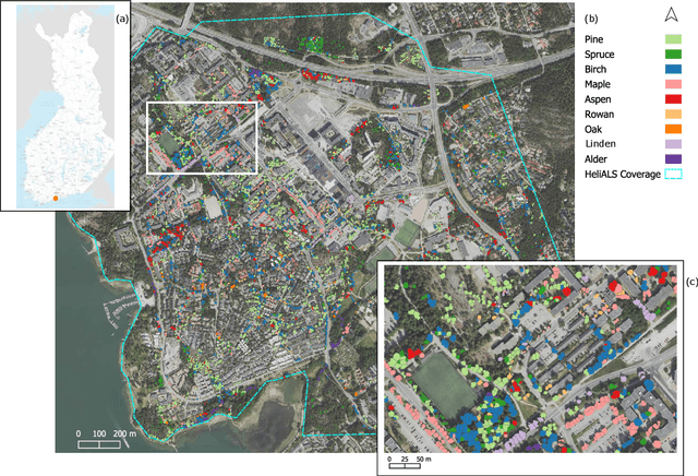
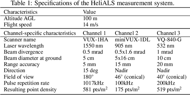
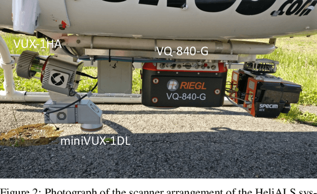
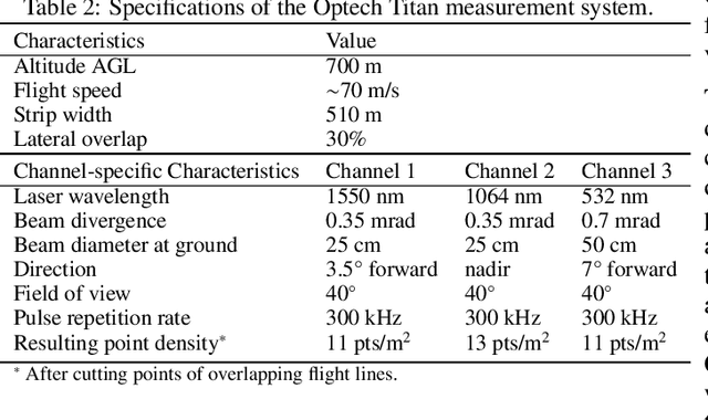
Climate-smart and biodiversity-preserving forestry demands precise information on forest resources, extending to the individual tree level. Multispectral airborne laser scanning (ALS) has shown promise in automated point cloud processing and tree segmentation, but challenges remain in identifying rare tree species and leveraging deep learning techniques. This study addresses these gaps by conducting a comprehensive benchmark of machine learning and deep learning methods for tree species classification. For the study, we collected high-density multispectral ALS data (>1000 pts/m$^2$) at three wavelengths using the FGI-developed HeliALS system, complemented by existing Optech Titan data (35 pts/m$^2$), to evaluate the species classification accuracy of various algorithms in a test site located in Southern Finland. Based on 5261 test segments, our findings demonstrate that point-based deep learning methods, particularly a point transformer model, outperformed traditional machine learning and image-based deep learning approaches on high-density multispectral point clouds. For the high-density ALS dataset, a point transformer model provided the best performance reaching an overall (macro-average) accuracy of 87.9% (74.5%) with a training set of 1065 segments and 92.0% (85.1%) with 5000 training segments. The best image-based deep learning method, DetailView, reached an overall (macro-average) accuracy of 84.3% (63.9%), whereas a random forest (RF) classifier achieved an overall (macro-average) accuracy of 83.2% (61.3%). Importantly, the overall classification accuracy of the point transformer model on the HeliALS data increased from 73.0% with no spectral information to 84.7% with single-channel reflectance, and to 87.9% with spectral information of all the three channels.
Benchmarking tree species classification from proximally-sensed laser scanning data: introducing the FOR-species20K dataset
Aug 12, 2024Proximally-sensed laser scanning offers significant potential for automated forest data capture, but challenges remain in automatically identifying tree species without additional ground data. Deep learning (DL) shows promise for automation, yet progress is slowed by the lack of large, diverse, openly available labeled datasets of single tree point clouds. This has impacted the robustness of DL models and the ability to establish best practices for species classification. To overcome these challenges, the FOR-species20K benchmark dataset was created, comprising over 20,000 tree point clouds from 33 species, captured using terrestrial (TLS), mobile (MLS), and drone laser scanning (ULS) across various European forests, with some data from other regions. This dataset enables the benchmarking of DL models for tree species classification, including both point cloud-based (PointNet++, MinkNet, MLP-Mixer, DGCNNs) and multi-view image-based methods (SimpleView, DetailView, YOLOv5). 2D image-based models generally performed better (average OA = 0.77) than 3D point cloud-based models (average OA = 0.72), with consistent results across different scanning platforms and sensors. The top model, DetailView, was particularly robust, handling data imbalances well and generalizing effectively across tree sizes. The FOR-species20K dataset, available at https://zenodo.org/records/13255198, is a key resource for developing and benchmarking DL models for tree species classification using laser scanning data, providing a foundation for future advancements in the field.
Virtual laser scanning with HELIOS++: A novel take on ray tracing-based simulation of topographic 3D laser scanning
Jan 21, 2021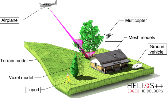
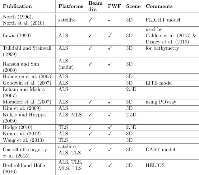
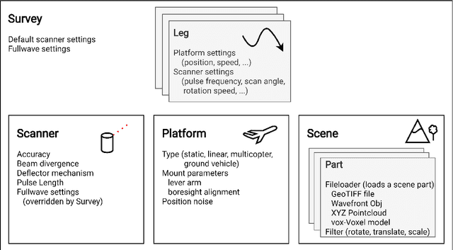
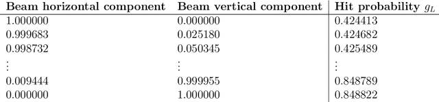
Topographic laser scanning is a remote sensing method to create detailed 3D point cloud representations of the Earth's surface. Since data acquisition is expensive, simulations can complement real data given certain premises are available: i) a model of 3D scene and scanner, ii) a model of the beam-scene interaction, simplified to a computationally feasible while physically realistic level, and iii) an application for which simulated data is fit for use. A number of laser scanning simulators for different purposes exist, which we enrich by presenting HELIOS++. HELIOS++ is an open-source simulation framework for terrestrial static, mobile, UAV-based and airborne laser scanning implemented in C++. The HELIOS++ concept provides a flexible solution for the trade-off between physical accuracy (realism) and computational complexity (runtime, memory footprint), as well as ease of use and of configuration. Unique features of HELIOS++ include the availability of Python bindings (pyhelios) for controlling simulations, and a range of model types for 3D scene representation. HELIOS++ further allows the simulation of beam divergence using a subsampling strategy, and is able to create full-waveform outputs as a basis for detailed analysis. As generation and analysis of waveforms can strongly impact runtimes, the user may set the level of detail for the subsampling, or optionally disable full-waveform output altogether. A detailed assessment of computational considerations and a comparison of HELIOS++ to its predecessor, HELIOS, reveal reduced runtimes by up to 83 %. At the same time, memory requirements are reduced by up to 94 %, allowing for much larger (i.e. more complex) 3D scenes to be loaded into memory and hence to be virtually acquired by laser scanning simulation.