 Add to Chrome
 Add to Firefox
 Add to Edge
Probabilistic Forecasting of Localized Wildfire Spread Based on Conditional Flow Matching
Mar 27, 2026This study presents a probabilistic surrogate model for localized wildfire spread based on a conditional flow matching algorithm. The approach models fire progression as a stochastic process by learning the conditional distribution of fire arrival times given the current fire state along with environmental and atmospheric inputs. Model inputs include current burned area, near-surface wind components, temperature, relative humidity, terrain height, and fuel category information, all defined on a high-resolution spatial grid. The outputs are samples of arrival time within a three-hour time window, conditioned on the input variables. Training data are generated from coupled atmosphere-wildfire spread simulations using WRF-SFIRE, paired with weather fields from the North American Mesoscale model. The proposed framework enables efficient generation of ensembles of arrival times and explicitly represents uncertainty arising from incomplete knowledge of the fire-atmosphere system and unresolved variables. The model supports localized prediction over subdomains, reducing computational cost relative to physics-based simulators while retaining sensitivity to key drivers of fire spread. Model performance is evaluated against WRF-SFIRE simulations for both single-step (3-hour) and recursive multi-step (24-hour) forecasts. Results demonstrate that the method captures variability in fire evolution and produces accurate ensemble predictions. The framework provides a scalable approach for probabilistic wildfire forecasting and offers a pathway for integrating machine learning models with operational fire prediction systems and data assimilation.
Solving physics-constrained inverse problems with conditional flow matching
Mar 14, 2026This study presents a conditional flow matching framework for solving physics-constrained Bayesian inverse problems. In this setting, samples from the joint distribution of inferred variables and measurements are assumed available, while explicit evaluation of the prior and likelihood densities is not required. We derive a simple and self-contained formulation of both the unconditional and conditional flow matching algorithms, tailored specifically to inverse problems. In the conditional setting, a neural network is trained to learn the velocity field of a probability flow ordinary differential equation that transports samples from a chosen source distribution directly to the posterior distribution conditioned on observed measurements. This black-box formulation accommodates nonlinear, high-dimensional, and potentially non-differentiable forward models without restrictive assumptions on the noise model. We further analyze the behavior of the learned velocity field in the regime of finite training data. Under mild architectural assumptions, we show that overtraining can induce degenerate behavior in the generated conditional distributions, including variance collapse and a phenomenon termed selective memorization, wherein generated samples concentrate around training data points associated with similar observations. A simplified theoretical analysis explains this behavior, and numerical experiments confirm it in practice. We demonstrate that standard early-stopping criteria based on monitoring test loss effectively mitigate such degeneracy. The proposed method is evaluated on several physics-based inverse problems. We investigate the impact of different choices of source distributions, including Gaussian and data-informed priors. Across these examples, conditional flow matching accurately captures complex, multimodal posterior distributions while maintaining computational efficiency.
Generative Algorithms for Wildfire Progression Reconstruction from Multi-Modal Satellite Active Fire Measurements and Terrain Height
Jun 12, 2025
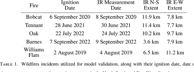


Increasing wildfire occurrence has spurred growing interest in wildfire spread prediction. However, even the most complex wildfire models diverge from observed progression during multi-day simulations, motivating need for data assimilation. A useful approach to assimilating measurement data into complex coupled atmosphere-wildfire models is to estimate wildfire progression from measurements and use this progression to develop a matching atmospheric state. In this study, an approach is developed for estimating fire progression from VIIRS active fire measurements, GOES-derived ignition times, and terrain height data. A conditional Generative Adversarial Network is trained with simulations of historic wildfires from the atmosphere-wildfire model WRF-SFIRE, thus allowing incorporation of WRF-SFIRE physics into estimates. Fire progression is succinctly represented by fire arrival time, and measurements for training are obtained by applying an approximate observation operator to WRF-SFIRE solutions, eliminating need for satellite data during training. The model is trained on tuples of fire arrival times, measurements, and terrain, and once trained leverages measurements of real fires and corresponding terrain data to generate samples of fire arrival times. The approach is validated on five Pacific US wildfires, with results compared against high-resolution perimeters measured via aircraft, finding an average Sorensen-Dice coefficient of 0.81. The influence of terrain height on the arrival time inference is also evaluated and it is observed that terrain has minimal influence when the inference is conditioned on satellite measurements.
Unifying and extending Diffusion Models through PDEs for solving Inverse Problems
Apr 10, 2025Diffusion models have emerged as powerful generative tools with applications in computer vision and scientific machine learning (SciML), where they have been used to solve large-scale probabilistic inverse problems. Traditionally, these models have been derived using principles of variational inference, denoising, statistical signal processing, and stochastic differential equations. In contrast to the conventional presentation, in this study we derive diffusion models using ideas from linear partial differential equations and demonstrate that this approach has several benefits that include a constructive derivation of the forward and reverse processes, a unified derivation of multiple formulations and sampling strategies, and the discovery of a new class of models. We also apply the conditional version of these models to solving canonical conditional density estimation problems and challenging inverse problems. These problems help establish benchmarks for systematically quantifying the performance of different formulations and sampling strategies in this study, and for future studies. Finally, we identify and implement a mechanism through which a single diffusion model can be applied to measurements obtained from multiple measurement operators. Taken together, the contents of this manuscript provide a new understanding and several new directions in the application of diffusion models to solving physics-based inverse problems.
Generative Algorithms for Fusion of Physics-Based Wildfire Spread Models with Satellite Data for Initializing Wildfire Forecasts
Sep 05, 2023
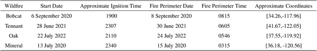


Increases in wildfire activity and the resulting impacts have prompted the development of high-resolution wildfire behavior models for forecasting fire spread. Recent progress in using satellites to detect fire locations further provides the opportunity to use measurements to improve fire spread forecasts from numerical models through data assimilation. This work develops a method for inferring the history of a wildfire from satellite measurements, providing the necessary information to initialize coupled atmosphere-wildfire models from a measured wildfire state in a physics-informed approach. The fire arrival time, which is the time the fire reaches a given spatial location, acts as a succinct representation of the history of a wildfire. In this work, a conditional Wasserstein Generative Adversarial Network (cWGAN), trained with WRF-SFIRE simulations, is used to infer the fire arrival time from satellite active fire data. The cWGAN is used to produce samples of likely fire arrival times from the conditional distribution of arrival times given satellite active fire detections. Samples produced by the cWGAN are further used to assess the uncertainty of predictions. The cWGAN is tested on four California wildfires occurring between 2020 and 2022, and predictions for fire extent are compared against high resolution airborne infrared measurements. Further, the predicted ignition times are compared with reported ignition times. An average Sorensen's coefficient of 0.81 for the fire perimeters and an average ignition time error of 32 minutes suggest that the method is highly accurate.