 Add to Chrome
 Add to Firefox
 Add to Edge
Generative Algorithms for Wildfire Progression Reconstruction from Multi-Modal Satellite Active Fire Measurements and Terrain Height
Paper and Code
Jun 12, 2025
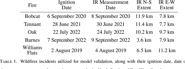


Increasing wildfire occurrence has spurred growing interest in wildfire spread prediction. However, even the most complex wildfire models diverge from observed progression during multi-day simulations, motivating need for data assimilation. A useful approach to assimilating measurement data into complex coupled atmosphere-wildfire models is to estimate wildfire progression from measurements and use this progression to develop a matching atmospheric state. In this study, an approach is developed for estimating fire progression from VIIRS active fire measurements, GOES-derived ignition times, and terrain height data. A conditional Generative Adversarial Network is trained with simulations of historic wildfires from the atmosphere-wildfire model WRF-SFIRE, thus allowing incorporation of WRF-SFIRE physics into estimates. Fire progression is succinctly represented by fire arrival time, and measurements for training are obtained by applying an approximate observation operator to WRF-SFIRE solutions, eliminating need for satellite data during training. The model is trained on tuples of fire arrival times, measurements, and terrain, and once trained leverages measurements of real fires and corresponding terrain data to generate samples of fire arrival times. The approach is validated on five Pacific US wildfires, with results compared against high-resolution perimeters measured via aircraft, finding an average Sorensen-Dice coefficient of 0.81. The influence of terrain height on the arrival time inference is also evaluated and it is observed that terrain has minimal influence when the inference is conditioned on satellite measurements.