 Add to Chrome
 Add to Firefox
 Add to Edge
Real-World LoRaWAN Performance and Propagation Modeling Using UAV, Helikite, and Vehicle-Based Measurements
Apr 07, 2026This paper presents a field-based evaluation of Long Range Wide Area Network (LoRaWAN) signal propagation conducted at two locations within the Aerial Experimentation and Research Platform for Advanced Wireless (AERPAW) testbed: Lake Wheeler Field and NC State University's Centennial Campus. Three distinct transmission platforms were deployed, a ground vehicle, a multirotor drone at 50 meters, and a helikite at a steady altitude of 150 meters and 300 meters approximately. These platforms enabled a comparative study on how altitude, mobility, and terrain influence wireless signal reception across a LoRaWAN gateway network. We analyze received signal strength (RSSI) and signal-to-noise ratio (SNR) as functions of distance and spreading factor (SF). Three complementary metrics are visualized: SNR versus distance with demodulation thresholds, probability of successful reception, and SNR boxplots grouped by distance bins. These plots reveal link degradation patterns and demonstrate the role of adaptive SF selection in maintaining communication reliability. To characterize propagation behavior, we apply a log-distance path loss model to empirical data from the ground vehicle experiment, which encompass both rural and urban non-line-of-sight (NLOS) conditions. Model parameters are optimized through error minimization techniques. Our results show that the helikite platform, due to its stable high-altitude position, provided the most reliable and consistent link performance. Conversely, the drone and vehicle exhibited higher variability due to movement, obstructions, and terrain-induced multipath. These findings demonstrate the influence of platform dynamics and altitude on LoRaWAN reception performance, providing support for future aerial network planning efforts.
Modeling and Analysis of Air-to-Ground Cellular KPIs in a 5G Testbed using Android Smartphones
Apr 06, 2026The integration of cellular communication with Unmanned Aerial Vehicles (UAVs) extends the range of command and control and payload communications of autonomous UAV applications. Accurate modeling of this air-to-ground wireless environment aids UAV mission planning. Models built on and insights obtained from real-life experiments intricately capture the variations in air-to-ground link quality with UAV position, offering more fidelity for simulations and system design than those that rely on generic theoretical models designed for ground scenarios or ray-tracing simulations. In this work, we conduct aerial flights at the Aerial Experimentation and Research Platform for Advanced Wireless (AERPAW) Lake Wheeler testbed to study the variation in key performance indicators (KPIs) of a private 4G/5G cellular base station (BS) with the UAV's altitude, distance from the BS, elevation, and azimuth relative to the BS. Variations in 4G and 5G physical layer KPIs and application layer throughput are logged and analyzed, using two Android smartphones: a Keysight Nemo device, with enhanced KPI access, through a rooted operating system, and a standard smartphone running a custom application that utilizes open-source Android APIs. The observed signal strength measurements are compared to theoretical predictions from free space path loss models that incorporate the BS antenna radiation patterns. Mathematical model parameters for polynomial curve approximations are derived to fit the observed data. Light machine learning approaches, namely random forests, gradient boosting regressors and neural networks, are used to model KPI behaviour as a function of UAV position relative to the BS. The insights and models generated from real-life experiments in this study can serve as valuable tools in the design, simulation and deployment of cellular communication-based UAV systems.
Height-Dependent Spectrum Activity Measurements and Modeling: A Case Study with FM Radio Bands
Feb 24, 2026The increasing demand for wireless connectivity necessitates advanced spectrum modeling to enable efficient spectrum sharing for next-generation aerial communications. While traditional models often overlook vertical variations in signal behavior, this paper proposes a height-dependent propagation model using a helikite-mounted software-defined radio (SDR). We collected extensive measurement data across the 88 MHz to 6 GHz range in both urban and rural environments. As a case study to validate our methodology, we focus on the FM radio band, which allows us to use publicly available transmitter locations and transmit power levels to facilitate comparisons between analytical with measurement results. We identify a clear transition from non-line-of-sight (NLoS) to line-of-sight (LoS) regimes at a specific altitude threshold and propose an altitude-dependent path loss model that incorporates this transition. Our results demonstrate that the proposed model significantly outperforms the standard free space path loss (FSPL) model in complex urban topologies, providing a more accurate framework for altitude-aware spectrum prediction and management across emerging aerial wireless technologies and bands.
Beyond Path Loss: Altitude-Dependent Spectral Structure Modeling for UAV Measurements
Jan 05, 2026This paper presents a measurement-based framework for characterizing altitude-dependent spectral behavior of signals received by a tethered Helikite unmanned aerial vehicle (UAV). Using a multi-year spectrum measurement campaign in an outdoor urban environment, power spectral density snapshots are collected over the 89 MHz--6 GHz range. Three altitude-dependent spectral metrics are extracted: band-average power, spectral entropy, and spectral sparsity. We introduce the Altitude-Dependent Spectral Structure Model (ADSSM) to characterize the spectral power and entropy using first-order altitude-domain differential equations, and spectral sparsity using a logistic function, yielding closed-form expressions with physically consistent asymptotic behavior. The model is fitted to altitude-binned measurements from three annual campaigns at the AERPAW testbed across six licensed and unlicensed sub-6 GHz bands. Across all bands and years, the ADSSM achieves low root-mean-square error and high coefficients of determination. Results indicate that power transitions occur over narrow low-altitude regions, while entropy and sparsity evolve over broader, band-dependent altitude ranges, demonstrating that altitude-dependent spectrum behavior is inherently multidimensional. By explicitly modeling altitude-dependent transitions in spectral structure beyond received power, the proposed framework enables spectrum-aware UAV sensing and band selection decisions that are not achievable with conventional power- or threshold-based occupancy models.
Digital Twins for Supporting AI Research with Autonomous Vehicle Networks
Apr 01, 2024


Digital twins (DTs), which are virtual environments that simulate, predict, and optimize the performance of their physical counterparts, are envisioned to be essential technologies for advancing next-generation wireless networks. While DTs have been studied extensively for wireless networks, their use in conjunction with autonomous vehicles with programmable mobility remains relatively under-explored. In this paper, we study DTs used as a development environment to design, deploy, and test artificial intelligence (AI) techniques that use real-time observations, e.g. radio key performance indicators, for vehicle trajectory and network optimization decisions in an autonomous vehicle networks (AVN). We first compare and contrast the use of simulation, digital twin (software in the loop (SITL)), sandbox (hardware-in-the-loop (HITL)), and physical testbed environments for their suitability in developing and testing AI algorithms for AVNs. We then review various representative use cases of DTs for AVN scenarios. Finally, we provide an example from the NSF AERPAW platform where a DT is used to develop and test AI-aided solutions for autonomous unmanned aerial vehicles for localizing a signal source based solely on link quality measurements. Our results in the physical testbed show that SITL DTs, when supplemented with data from real-world (RW) measurements and simulations, can serve as an ideal environment for developing and testing innovative AI solutions for AVNs.
UAV Corridor Coverage Analysis with Base Station Antenna Uptilt and Strongest Signal Association
Mar 27, 2024


Unmanned aerial vehicle (UAV) corridors are sky lanes where UAVs fly through safely between their origin and destination. To ensure the successful operation of UAV corridors, beyond visual line of sight (BVLOS) wireless connectivity within the corridor is crucial. One promising solution to support this is the use of cellular-connected UAV (C-UAV) networks, which offer long-range and seamless wireless coverage. However, conventional terrestrial base stations (BSs) that typically employ down-tilted sector antennas to serve ground users are not ideally suited to serve the aerial vehicles positioned above the BSs. In our previous work, we focused on studying the optimal uptilt angle of BS antennas to maximize the wireless coverage probability in UAV corridors. However, the association of BSs with UAVs was restricted to the nearest BS association, which limits the potential coverage benefits. In this paper, we address this limitation by considering the strongest BS signal association in UAV corridors, which enables enhanced coverage within the corridor compared to the nearest BS association. The strongest BS association allows UAVs to connect with the second nearest BSs while also accounting for interference from the third nearest BSs. Closed-form expression analysis and simulation results show that the strongest BSs association in UAV corridors yields a superior coverage probability when compared to the nearest BS association.
Impact of 3D Antenna Radiation Pattern in UAV Air-to-Ground Path Loss Modeling and RSRP-based Localization in Rural Area
Jul 24, 2023Ensuring reliable and seamless wireless connectivity for unmanned aerial vehicles (UAVs) has emerged as a critical requirement for a wide range of applications. The increasing deployment of UAVs has increased the significance of cellular-connected UAVs (C-UAVs) in enabling beyond-visual line of sight (BVLOS) communications. To ensure the successful operation of C-UAVs within existing terrestrial networks, it is vital to understand the distinctive characteristics associated with air-to-ground signal propagation. In this paper, we investigate the impact of 3D antenna patterns on a UAV air-to-ground path loss model, utilizing datasets obtained from a measurement campaign. We conducted UAV experiments in a rural area at various fixed heights, while also characterizing the 3D antenna radiation pattern by using an anechoic chamber facility. By analyzing reference signal received power (RSRP) using path loss models that account for antenna patterns, we observed that our measurement results, obtained at different UAV heights, aligned well with the two-ray path loss model when incorporating the measured antenna pattern. we propose an RSRP-based localization algorithm at a UAV that takes into account antenna patterns in both offline and online scenarios. Through our experimentation dataset, we show that incorporating measured antenna patterns significantly enhances the source localization accuracy.
SDR-Based 5G NR C-Band I/Q Monitoring and Surveillance in Urban Area Using a Helikite
Mar 03, 2023In this paper, we report experimental results in collectting and processing 5G NR I/Q samples in the 3.7~GHz C-band by using software-defined radio (SDR)-mounted helikite. We use MATLAB's 5G toolbox to post-process the collected data, to obtain the synchronization signal block (SSB) from the I/Q samples and then go through the cell search, synchronization procedures, and reference signal received power (RSRP) and reference signal received quality (RSRQ) calculation. We plot these performance metrics for various physical cell identities as a function of the helikite's altitude. Furthermore, building on our experience with the collected and post-processed data, we discuss potential vulnerabilities of 5G NR systems to surveillance, jamming attacks, and post quantum era attacks.
LTE I/Q Data Set for UAV Propagation Modeling, Communication, and Navigation Research
Mar 03, 2023Recently, unmanned aerial vehicles (UAVs) have been receiving significant attention due to their wide range of potential application areas. To support UAV use cases with beyond visual line of sight (BVLOS) and autonomous flights, cellular networks can serve as ground connectivity points, and they can provide remote control and payload communication for UAV links. However, there are limited data sets to study the coverage of cellular technologies for UAV flights at different altitudes and develop machine learning (ML) techniques for improving UAV communication and navigation. In this article, we present raw LTE I/Q sample data sets from physical field experiments in the Lake Wheeler farm area of the NSF AERPAW experimentation platform. We fly a UAV that carries a software-defined radio (SDR) at altitudes ranging from 30~m to 110~m and collect raw I/Q samples from an SDR-based LTE base station on the ground operating at 3.51 GHz. We adopt a standard metadata format for reproducing the results from the collected data sets. The post-processing of raw I/Q samples using MATLAB's 4G LTE toolbox is described and various representative results are provided. In the end, we discuss the possible ways that our provided data set, post-processing sample code, and sample experiment code for collecting I/Q measurements and vehicle control can be used by other ML researchers in the future.
AERIQ: SDR-Based LTE I/Q Measurement and Analysis Framework for Air-to-Ground Propagation Modeling
Oct 14, 2022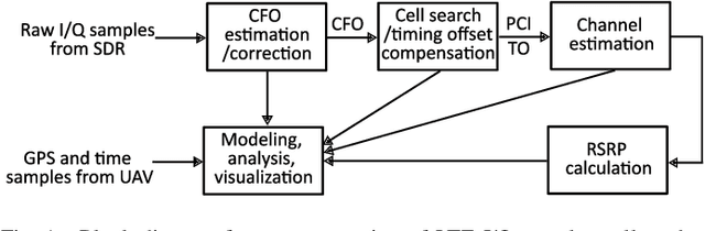
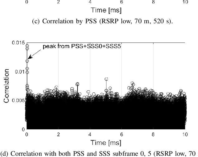
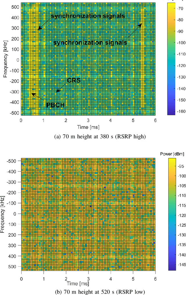
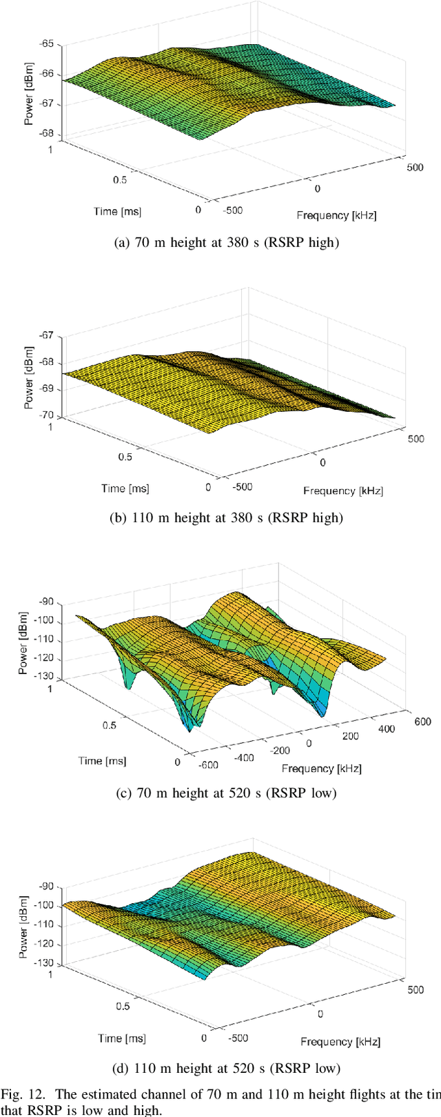
Radio dynamic zones (RDZs) are areas or volumes with automatic spectrum management mechanisms that control electromagnetic energy entering, escaping, or occupying the zone. In order to have real-time volumetric spectrum awareness in an RDZ, it is critical to understand the propagation characteristics throughout that RDZ, such as time, frequency, and spatial correlation for various communications scenarios and configurations. This requires wireless measurement campaigns that can be carried out flexibly and are repeatable for different experiment configurations, parameters, and transmitter/receiver locations. Such measurements should also provide raw data from which various key parameters of interest (KPIs) can be conveniently extracted for further analysis. In this paper, we propose AERIQ: a software-defined radio (SDR) based I/Q measurement and analysis framework that is flexible, repeatable, and provides raw I/Q samples for post-processing the data to extract various KPIs. Using SDRs, we collect I/Q data with unmanned aerial vehicles (UAVs) flying at various different altitudes in an RDZ-like outdoor environment, from a 4G LTE eNB that we configure to operate at 3.51 GHz. Using the raw I/Q samples, and using Matlab's LTE Toolbox, we provide a step-by-step description for the following post-processing stages of an aerial receiver: frequency offset estimation/correction, synchronization, cell search, channel estimation, and reference signal received power (RSRP). We provide various representative results for each step, such as RSRP measurements and corresponding analytical approximation at different UAV altitudes, and coherence bandwidth of the channel at different UAV altitudes and link distances. The collected raw data as well as the software developed for obtaining and post-processing such data are provided publicly for potential use by other researchers.