 Add to Chrome
 Add to Firefox
 Add to Edge
GeoSeg-OV: Bridging Geospatial Gaps with Structural Guidance for Open-Vocabulary Remote Sensing Segmentation
Aug 11, 2026
Open-vocabulary remote sensing segmentation has recently emerged as a promising paradigm that enables pixel-level recognition of arbitrary categories specified by natural language, including classes unseen during training. However, geospatial domain shifts caused by heterogeneous regions, spatial resolutions, and acquisition platforms weaken visual-text matching and limit cross-dataset generalization. Recent attempts have begun to incorporate auxiliary vision foundation models (VFMs), typically coupling their features with text embeddings as additional matching evidence. However, this strategy may introduce inconsistent matching signals while leaving the structure-sensitive representations of VFMs insufficiently exploited. We therefore propose GeoSeg-OV, which decouples auxiliary VFM features from visual-text matching and repurposes them as structural guidance for cost aggregation and decoding. GeoSeg-OV constructs an orientation-robust cost volume from multi-rotation CLIP features, while a frozen VFM extracts multi-scale structure-sensitive features in parallel. We propose Structure-Guided Aggregation (SGA), which integrates cost tokens and CLIP semantic guidance with VFM-derived pairwise structural biases for coherent spatial propagation, followed by text-conditioned class-wise reasoning. We further introduce Cost-Aware Decoding (CAD) to adaptively refine and fuse multi-scale semantic and structural guidance based on the current decoder context. On the global High-Resolution Land Cover (HRLC) benchmark spanning seven datasets across six continents, GeoSeg-OV outperforms the state-of-the-art by +2.5 and +2.7 average mIoU under two training settings. A large-scale zero-shot case study further demonstrates its generalization across geographic domains and category systems without target-domain annotations or retraining.

CoRE-UIR: Prior-guided common and residual experts for efficient all-in-one remote sensing image restoration
Jul 30, 2026Remote sensing images acquired by unmanned aerial vehicles (UAVs) and satellites are often degraded by adverse weather, illumination variation, and imaging artifacts, which may co-occur and jointly induce global distribution shifts and local structural corruption. Although All-in-One image restoration offers an appealing unified alternative to task-specific pipelines, existing methods still suffer from weak or implicit degradation cues and parameter redundancy caused by full-rank multi-expert designs with overlapping restoration behaviors. We propose CoRE-UIR (Common and Residual Experts for Universal Image Restoration), a prior-guided global-local framework centered on the Common-and-Residual Expert Block (CoRE). CoRE explicitly decomposes restoration capacity into a common dense expert for degradation-invariant restoration and low-rank residual experts for degradation-specific compensation, enabling adaptive specialization without redundant expert replication. Built on this design, Degradation Prior Embedding (DPE) adapts frozen CLIP features into an explicit restoration-oriented prior, while Global Feature Modulation (GFM) aligns global feature statistics before local residual compensation. We also construct MDVD-108K (Multi-Degradation VisDrone), a large-scale UAV restoration dataset covering both single and compound degradations, together with a real-world test set. Extensive experiments on multiple datasets show that CoRE-UIR improves the overall average PSNR by 1.05 dB while running 11.83$\times$ faster and reducing peak memory by 85.3% relative to the strongest baseline, BaryIR, thereby maintaining a favorable quality-efficiency trade-off. Evaluations on downstream tasks and unseen degradation also validate the generalizability of CoRE-UIR. The code and dataset will be released at https://github.com/zzaiyan/CoRE-UIR.
Task-Driven Prompt Learning: A Joint Framework for Multi-modal Cloud Removal and Segmentation
Jan 17, 2026Optical remote sensing imagery is indispensable for Earth observation, yet persistent cloud occlusion limits its downstream utility. Most cloud removal (CR) methods are optimized for low-level fidelity and can over-smooth textures and boundaries that are critical for analysis-ready data (ARD), leading to a mismatch between visually plausible restoration and semantic utility. To bridge this gap, we propose TDP-CR, a task-driven multimodal framework that jointly performs cloud removal and land-cover segmentation. Central to our approach is a Prompt-Guided Fusion (PGF) mechanism, which utilizes a learnable degradation prompt to encode cloud thickness and spatial uncertainty. By combining global channel context with local prompt-conditioned spatial bias, PGF adaptively integrates Synthetic Aperture Radar (SAR) information only where optical data is corrupted. We further introduce a parameter-efficient two-phase training strategy that decouples reconstruction and semantic representation learning. Experiments on the LuojiaSET-OSFCR dataset demonstrate the superiority of our framework: TDP-CR surpasses heavy state-of-the-art baselines by 0.18 dB in PSNR while using only 15\% of the parameters, and achieves a 1.4\% improvement in mIoU consistently against multi-task competitors, effectively delivering analysis-ready data.
Multi-scale Restoration of Missing Data in Optical Time-series Images with Masked Spatial-Temporal Attention Network
Jun 19, 2024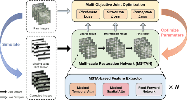


Due to factors such as thick cloud cover and sensor limitations, remote sensing images often suffer from significant missing data, resulting in incomplete time-series information. Existing methods for imputing missing values in remote sensing images do not fully exploit spatio-temporal auxiliary information, leading to limited accuracy in restoration. Therefore, this paper proposes a novel deep learning-based approach called MS2TAN (Multi-scale Masked Spatial-Temporal Attention Network), for reconstructing time-series remote sensing images. Firstly, we introduce an efficient spatio-temporal feature extractor based on Masked Spatial-Temporal Attention (MSTA), to obtain high-quality representations of the spatio-temporal neighborhood features in the missing regions. Secondly, a Multi-scale Restoration Network consisting of the MSTA-based Feature Extractors, is employed to progressively refine the missing values by exploring spatio-temporal neighborhood features at different scales. Thirdly, we propose a ``Pixel-Structure-Perception'' Multi-Objective Joint Optimization method to enhance the visual effects of the reconstruction results from multiple perspectives and preserve more texture structures. Furthermore, the proposed method reconstructs missing values in all input temporal phases in parallel (i.e., Multi-In Multi-Out), achieving higher processing efficiency. Finally, experimental evaluations on two typical missing data restoration tasks across multiple research areas demonstrate that the proposed method outperforms state-of-the-art methods with an improvement of 0.40dB/1.17dB in mean peak signal-to-noise ratio (mPSNR) and 3.77/9.41 thousandths in mean structural similarity (mSSIM), while exhibiting stronger texture and structural consistency.