 Add to Chrome
 Add to Firefox
 Add to Edge
MoRAX: Mobility-based Representation Augmentation for Geospatial Foundation Models
Aug 18, 2026
Geospatial Foundation Models (GFMs) are emerging as a powerful paradigm for learning semantically rich and geographically consistent visual and physical representations. However, their reliance on Earth-observation (EO) data leaves information about human activity largely underrepresented. Human mobility data reveals the functional and relational structure between regions that is missing from EO data, but is often limited only to the city where it is observed, making it challenging to use for transferable urban representation learning. We introduce MoRAX, a lightweight framework for augmenting geospatial embeddings with functional structure derived from human mobility. MoRAX preserves the coverage and consistency of a GFM while providing information about the functional connectivity among urban regions, permitting zero-shot deployment in unseen cities with or without available mobility data. Across four target cities spanning two countries, the MoRAX teacher model, which observes mobility, consistently outperforms GFMs and strong urban representation baselines in eight socioeconomic and environmental prediction tasks. Meanwhile, the student model, which never takes mobility data as input, approaches the teacher in performance on most tasks. Transfer results across countries further demonstrate that modulation conditioned on mobility flows provides a general mechanism for grounding geospatial foundations in the human dimension of cities.

Using Drone Swarm to Stop Wildfire: A Predict-then-optimize Approach
Nov 25, 2024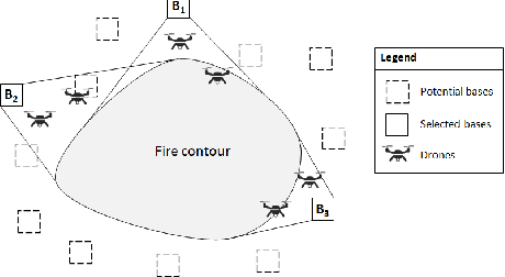
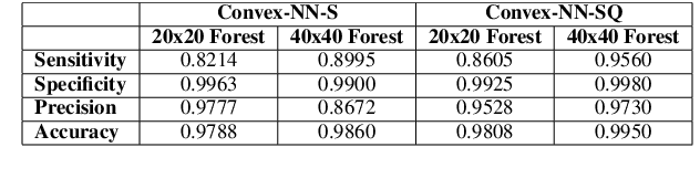


Drone swarms coupled with data intelligence can be the future of wildfire fighting. However, drone swarm firefighting faces enormous challenges, such as the highly complex environmental conditions in wildfire scenes, the highly dynamic nature of wildfire spread, and the significant computational complexity of drone swarm operations. We develop a predict-then-optimize approach to address these challenges to enable effective drone swarm firefighting. First, we construct wildfire spread prediction convex neural network (Convex-NN) models based on real wildfire data. Then, we propose a mixed-integer programming (MIP) model coupled with dynamic programming (DP) to enable efficient drone swarm task planning. We further use chance-constrained robust optimization (CCRO) to ensure robust firefighting performances under varying situations. The formulated model is solved efficiently using Benders Decomposition and Branch-and-Cut algorithms. After 75 simulated wildfire environments training, the MIP+CCRO approach shows the best performance among several testing sets, reducing movements by 37.3\% compared to the plain MIP. It also significantly outperformed the GA baseline, which often failed to fully extinguish the fire. Eventually, we will conduct real-world fire spread and quenching experiments in the next stage for further validation.
Demo2Vec: Learning Region Embedding with Demographic Information
Sep 25, 2024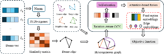

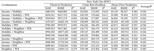
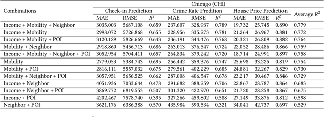
Demographic data, such as income, education level, and employment rate, contain valuable information of urban regions, yet few studies have integrated demographic information to generate region embedding. In this study, we show how the simple and easy-to-access demographic data can improve the quality of state-of-the-art region embedding and provide better predictive performances in urban areas across three common urban tasks, namely check-in prediction, crime rate prediction, and house price prediction. We find that existing pre-train methods based on KL divergence are potentially biased towards mobility information and propose to use Jenson-Shannon divergence as a more appropriate loss function for multi-view representation learning. Experimental results from both New York and Chicago show that mobility + income is the best pre-train data combination, providing up to 10.22\% better predictive performances than existing models. Considering that mobility big data can be hardly accessible in many developing cities, we suggest geographic proximity + income to be a simple but effective data combination for region embedding pre-training.
Evolutionary Greedy Algorithm for Optimal Sensor Placement Problem in Urban Sewage Surveillance
Sep 25, 2024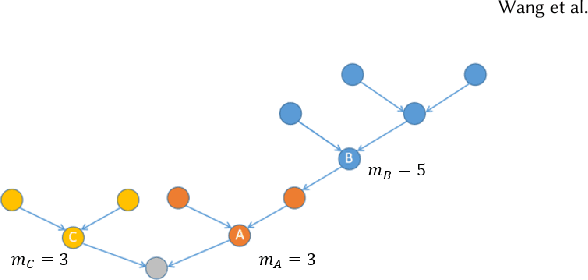

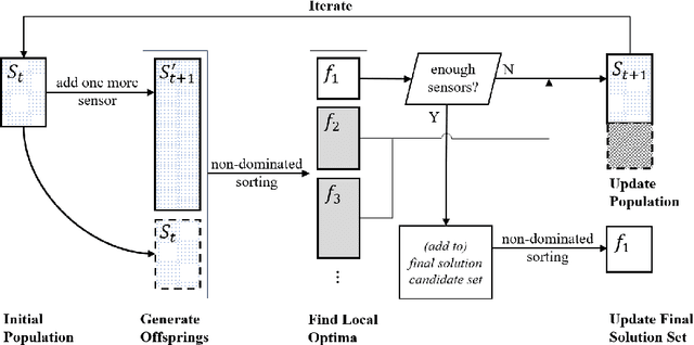
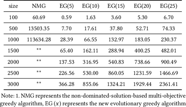
Designing a cost-effective sensor placement plan for sewage surveillance is a crucial task because it allows cost-effective early pandemic outbreak detection as supplementation for individual testing. However, this problem is computationally challenging to solve, especially for massive sewage networks having complicated topologies. In this paper, we formulate this problem as a multi-objective optimization problem to consider the conflicting objectives and put forward a novel evolutionary greedy algorithm (EG) to enable efficient and effective optimization for large-scale directed networks. The proposed model is evaluated on both small-scale synthetic networks and a large-scale, real-world sewage network in Hong Kong. The experiments on small-scale synthetic networks demonstrate a consistent efficiency improvement with reasonable optimization performance and the real-world application shows that our method is effective in generating optimal sensor placement plans to guide policy-making.