 Add to Chrome
 Add to Firefox
 Add to Edge
The Llama 4 Herd: Architecture, Training, Evaluation, and Deployment Notes
Jan 15, 2026This document consolidates publicly reported technical details about Metas Llama 4 model family. It summarizes (i) released variants (Scout and Maverick) and the broader herd context including the previewed Behemoth teacher model, (ii) architectural characteristics beyond a high-level MoE description covering routed/shared-expert structure, early-fusion multimodality, and long-context design elements reported for Scout (iRoPE and length generalization strategies), (iii) training disclosures spanning pre-training, mid-training for long-context extension, and post-training methodology (lightweight SFT, online RL, and lightweight DPO) as described in release materials, (iv) developer-reported benchmark results for both base and instruction-tuned checkpoints, and (v) practical deployment constraints observed across major serving environments, including provider-specific context limits and quantization packaging. The manuscript also summarizes licensing obligations relevant to redistribution and derivative naming, and reviews publicly described safeguards and evaluation practices. The goal is to provide a compact technical reference for researchers and practitioners who need precise, source-backed facts about Llama 4.
Sat2Flow: A Structure-Aware Diffusion Framework for Human Flow Generation from Satellite Imagery
Aug 27, 2025Origin-Destination (OD) flow matrices are essential for urban mobility analysis, underpinning applications in traffic forecasting, infrastructure planning, and policy design. However, existing methods suffer from two critical limitations: (1) reliance on auxiliary features (e.g., Points of Interest, socioeconomic statistics) that are costly to collect and have limited spatial coverage; and (2) sensitivity to spatial topology, where minor index reordering of urban regions (e.g., census tract relabeling) disrupts structural coherence in generated flows. To address these challenges, we propose Sat2Flow, a latent structure-aware diffusion-based framework that generates structurally coherent OD flows using solely satellite imagery as input. Our approach introduces a multi-kernel encoder to capture diverse regional interactions and employs a permutation-aware diffusion process that aligns latent representations across different regional orderings. Through a joint contrastive training objective that bridges satellite-derived features with OD patterns, combined with equivariant diffusion training that enforces structural consistency, Sat2Flow ensures topological robustness under arbitrary regional reindexing. Experimental results on real-world urban datasets demonstrate that Sat2Flow outperforms both physics-based and data-driven baselines in numerical accuracy while preserving empirical distributions and spatial structures under index permutations. Sat2Flow offers a globally scalable solution for OD flow generation in data-scarce urban environments, eliminating region-specific auxiliary data dependencies while maintaining structural invariance for robust mobility modeling.
Urban Representation Learning for Fine-grained Economic Mapping: A Semi-supervised Graph-based Approach
May 16, 2025


Fine-grained economic mapping through urban representation learning has emerged as a crucial tool for evidence-based economic decisions. While existing methods primarily rely on supervised or unsupervised approaches, they often overlook semi-supervised learning in data-scarce scenarios and lack unified multi-task frameworks for comprehensive sectoral economic analysis. To address these gaps, we propose SemiGTX, an explainable semi-supervised graph learning framework for sectoral economic mapping. The framework is designed with dedicated fusion encoding modules for various geospatial data modalities, seamlessly integrating them into a cohesive graph structure. It introduces a semi-information loss function that combines spatial self-supervision with locally masked supervised regression, enabling more informative and effective region representations. Through multi-task learning, SemiGTX concurrently maps GDP across primary, secondary, and tertiary sectors within a unified model. Extensive experiments conducted in the Pearl River Delta region of China demonstrate the model's superior performance compared to existing methods, achieving R2 scores of 0.93, 0.96, and 0.94 for the primary, secondary and tertiary sectors, respectively. Cross-regional experiments in Beijing and Chengdu further illustrate its generality. Systematic analysis reveals how different data modalities influence model predictions, enhancing explainability while providing valuable insights for regional development planning. This representation learning framework advances regional economic monitoring through diverse urban data integration, providing a robust foundation for precise economic forecasting.
Mapping Urban Villages in China: Progress and Challenges
Mar 18, 2025


The shift toward high-quality urbanization has brought increased attention to the issue of "urban villages", which has become a prominent social problem in China. However, there is a lack of available geospatial data on urban villages, making it crucial to prioritize urban village mapping. In order to assess the current progress in urban village mapping and identify challenges and future directions, we have conducted a comprehensive review, which to the best of our knowledge is the first of its kind in this field. Our review begins by providing a clear context for urban villages and elaborating the method for literature review, then summarizes the study areas, data sources, and approaches used for urban village mapping in China. We also address the challenges and future directions for further research. Through thorough investigation, we find that current studies only cover very limited study areas and periods and lack sufficient investigation into the scalability, transferability, and interpretability of identification approaches due to the challenges in concept fuzziness and variances, spatial heterogeneity and variances of urban villages, and data availability. Future research can complement and further the current research in the following potential directions in order to achieve large-area mapping across the whole nation...
* Updated review at https://github.com/rui-research/urban-village-review
Spatio-temporal Parking Behaviour Forecasting and Analysis Before and During COVID-19
Aug 15, 2021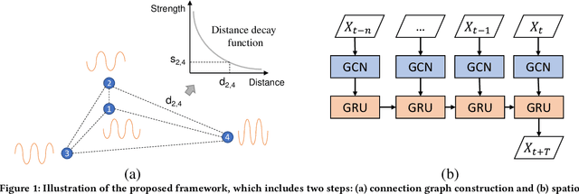
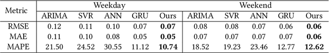
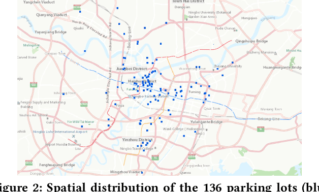
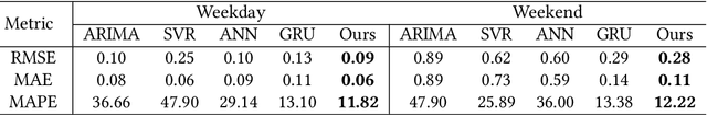
Parking demand forecasting and behaviour analysis have received increasing attention in recent years because of their critical role in mitigating traffic congestion and understanding travel behaviours. However, previous studies usually only consider temporal dependence but ignore the spatial correlations among parking lots for parking prediction. This is mainly due to the lack of direct physical connections or observable interactions between them. Thus, how to quantify the spatial correlation remains a significant challenge. To bridge the gap, in this study, we propose a spatial-aware parking prediction framework, which includes two steps, i.e. spatial connection graph construction and spatio-temporal forecasting. A case study in Ningbo, China is conducted using parking data of over one million records before and during COVID-19. The results show that the approach is superior on parking occupancy forecasting than baseline methods, especially for the cases with high temporal irregularity such as during COVID-19. Our work has revealed the impact of the pandemic on parking behaviour and also accentuated the importance of modelling spatial dependence in parking behaviour forecasting, which can benefit future studies on epidemiology and human travel behaviours.