 Add to Chrome
 Add to Firefox
 Add to Edge
A Machine Learning Based Search for Lunar Anomalies
Aug 10, 2026
The Lunar Reconnaissance Orbiter (LRO) has been collecting high-resolution images (at around 0.5-2 meters per pixel linearly with its Narrow Angle Camera) of the Moon since 2009, amassing a large dataset of images and offering researchers the opportunity to study the surface of the Moon at unprecedented scale. Here, we aim to test the abilities of the Beta-Variational Autoencoder (VAE) created by Lesnikowski et al. (2024), an unsupervised learning model which identifies anomalous features across the Moon's surface, locating not only scientifically useful geologic formations such as rockfall deposits, fresh impact craters, irregular mare patches, or volcanic pits/collapsed lava tubes, but also artificial objects such as landed spacecraft. This investigation further gauged the model's ability to locate anomalous surface features, successfully recovering two places of interest (Plaskett Crater and Paracelsus C Crater) and numerous landed technological assets at a statistically significant rate.

LunarFM: A Shared Multimodal Representation of the Moon's Surface
Jul 24, 2026The renewed global focus on lunar exploration, driven by the prospect of in-situ resource utilization and a sustained human presence on the Moon, has created growing demand for accurate, large-scale characterization of the lunar surface. Although vast quantities of orbital remote-sensing data have been collected, scientific analysis and resource mapping remain fragmented by heterogeneous multiinstrument observations, sparse labels, and bespoke task-specific modelling workflows. Here we introduce LunarFM, a multimodal foundation model that learns a general representation of the lunar surface from diverse orbital measurements. LunarFM assimilates observations from six instruments across three lunar missions, mapping 18 input channels to a shared embedding space. We demonstrate that this embedding space supports a diverse range of downstream applications, including similarity search, few-shot resource mapping, mineral abundance regression, and geological unit classification, enabling efficient scientific investigation and resource-oriented analysis. We provide a machine-learning-ready dataset of co-registered multimodal observations spanning latitudes from 70°S to 70°N, a pretrained multimodal masked autoencoder, and a companion embedding dataset providing a joint 768-dimensional representation of lunar surface properties. All code and data are available at https://lunarfm.trillium.tech/
A Practical Framework of Key Performance Indicators for Multi-Robot Lunar and Planetary Field Tests
Jan 28, 2026Robotic prospecting for critical resources on the Moon, such as ilmenite, rare earth elements, and water ice, requires robust exploration methods given the diverse terrain and harsh environmental conditions. Although numerous analog field trials address these goals, comparing their results remains challenging because of differences in robot platforms and experimental setups. These missions typically assess performance using selected, scenario-specific engineering metrics that fail to establish a clear link between field performance and science-driven objectives. In this paper, we address this gap by deriving a structured framework of KPI from three realistic multi-robot lunar scenarios reflecting scientific objectives and operational constraints. Our framework emphasizes scenario-dependent priorities in efficiency, robustness, and precision, and is explicitly designed for practical applicability in field deployments. We validated the framework in a multi-robot field test and found it practical and easy to apply for efficiency- and robustness-related KPI, whereas precision-oriented KPI require reliable ground-truth data that is not always feasible to obtain in outdoor analog environments. Overall, we propose this framework as a common evaluation standard enabling consistent, goal-oriented comparison of multi-robot field trials and supporting systematic development of robotic systems for future planetary exploration.
Using Machine Learning to Reduce Observational Biases When Detecting New Impacts on Mars
Jul 12, 2022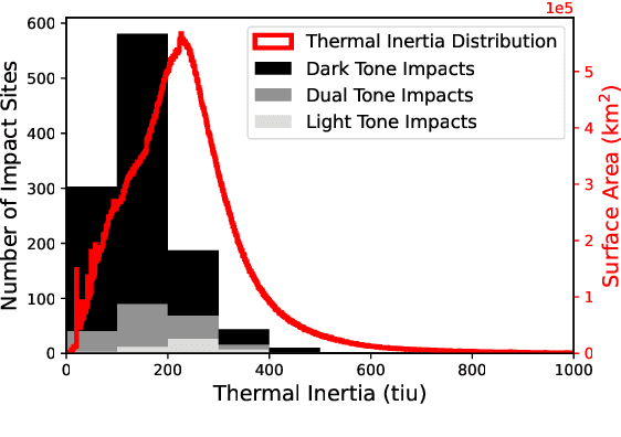
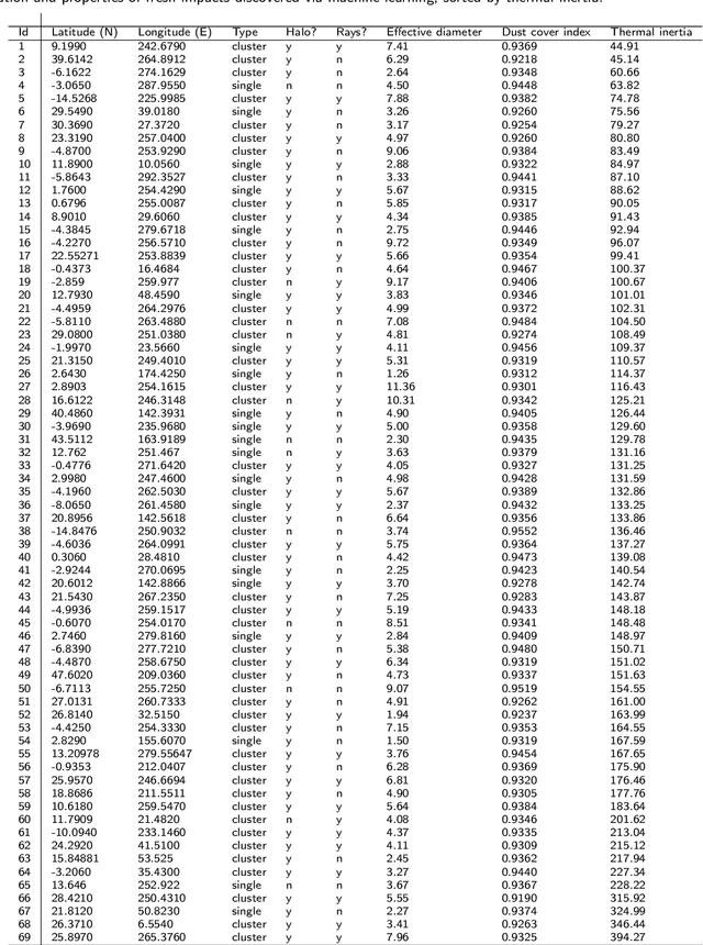
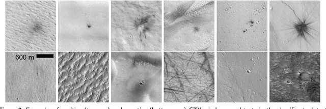
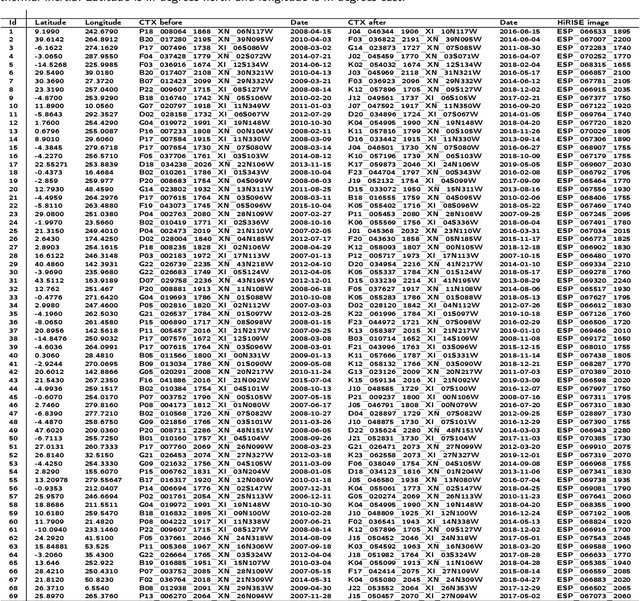
The current inventory of recent (fresh) impacts on Mars shows a strong bias towards areas of low thermal inertia. These areas are generally visually bright, and impacts create dark scours and rays that make them easier to detect. It is expected that impacts occur at a similar rate in areas of higher thermal inertia, but those impacts are under-detected. This study investigates the use of a trained machine learning classifier to increase the detection of fresh impacts on Mars using CTX data. This approach discovered 69 new fresh impacts that have been confirmed with follow-up HiRISE images. We found that examining candidates partitioned by thermal inertia (TI) values, which is only possible due to the large number of machine learning candidates, helps reduce the observational bias and increase the number of known high-TI impacts.
* 17 pages, 10 figures, 2 tables (Author's preprint, accepted version)
Unsupervised Distribution Learning for Lunar Surface Anomaly Detection
Jan 14, 2020


In this work we show that modern data-driven machine learning techniques can be successfully applied on lunar surface remote sensing data to learn, in an unsupervised way, sufficiently good representations of the data distribution to enable lunar technosignature and anomaly detection. In particular we train an unsupervised distribution learning neural network model to find the Apollo 15 landing module in a testing dataset, with no dataset specific model or hyperparameter tuning. Sufficiently good unsupervised data density estimation has the promise of enabling myriad useful downstream tasks, including locating lunar resources for future space flight and colonization, finding new impact craters or lunar surface reshaping, and algorithmically deciding the importance of unlabeled samples to send back from power- and bandwidth-constrained missions. We show in this work that such unsupervised learning can be successfully done in the lunar remote sensing and space science contexts.