 Add to Chrome
 Add to Firefox
 Add to Edge
SensatUrban: Learning Semantics from Urban-Scale Photogrammetric Point Clouds
Jan 12, 2022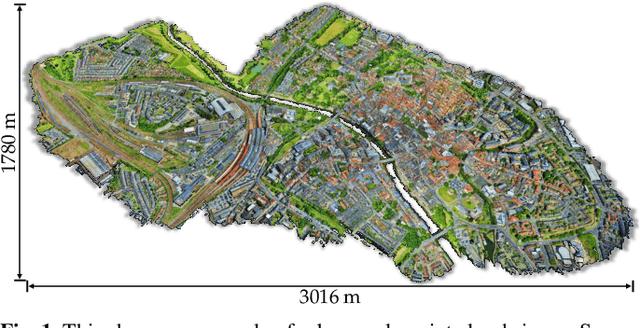
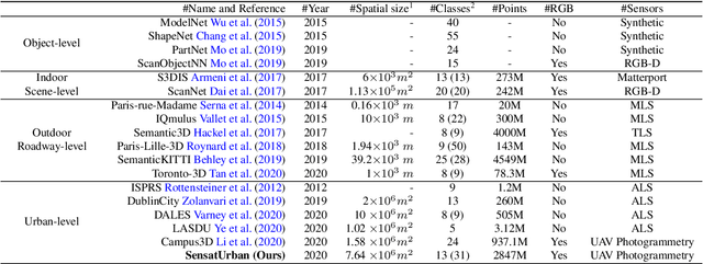
With the recent availability and affordability of commercial depth sensors and 3D scanners, an increasing number of 3D (i.e., RGBD, point cloud) datasets have been publicized to facilitate research in 3D computer vision. However, existing datasets either cover relatively small areas or have limited semantic annotations. Fine-grained understanding of urban-scale 3D scenes is still in its infancy. In this paper, we introduce SensatUrban, an urban-scale UAV photogrammetry point cloud dataset consisting of nearly three billion points collected from three UK cities, covering 7.6 km^2. Each point in the dataset has been labelled with fine-grained semantic annotations, resulting in a dataset that is three times the size of the previous existing largest photogrammetric point cloud dataset. In addition to the more commonly encountered categories such as road and vegetation, urban-level categories including rail, bridge, and river are also included in our dataset. Based on this dataset, we further build a benchmark to evaluate the performance of state-of-the-art segmentation algorithms. In particular, we provide a comprehensive analysis and identify several key challenges limiting urban-scale point cloud understanding. The dataset is available at http://point-cloud-analysis.cs.ox.ac.uk.
Towards Semantic Segmentation of Urban-Scale 3D Point Clouds: A Dataset, Benchmarks and Challenges
Sep 07, 2020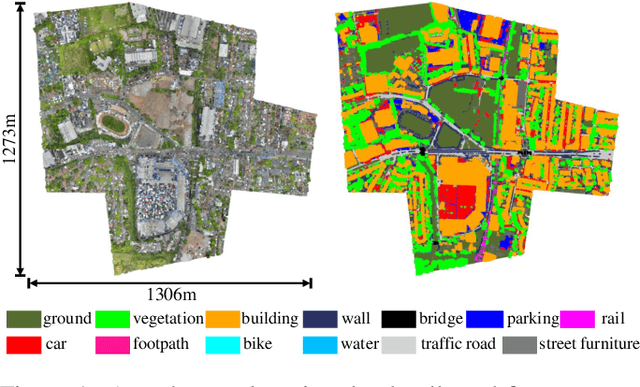
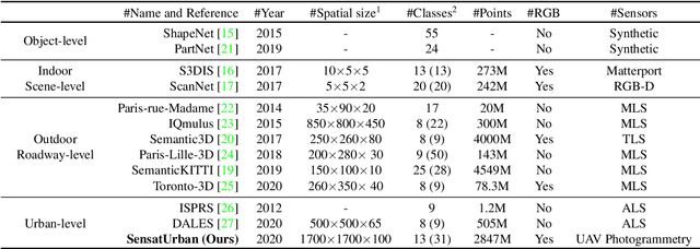
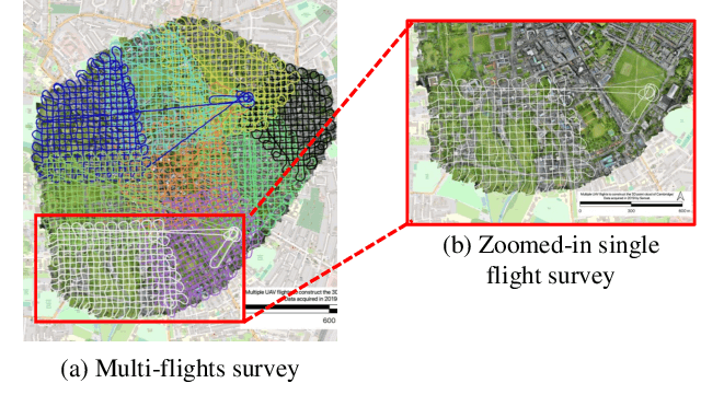
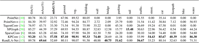
An essential prerequisite for unleashing the potential of supervised deep learning algorithms in the area of 3D scene understanding is the availability of large-scale and richly annotated datasets. However, publicly available datasets are either in relative small spatial scales or have limited semantic annotations due to the expensive cost of data acquisition and data annotation, which severely limits the development of fine-grained semantic understanding in the context of 3D point clouds. In this paper, we present an urban-scale photogrammetric point cloud dataset with nearly three billion richly annotated points, which is five times the number of labeled points than the existing largest point cloud dataset. Our dataset consists of large areas from two UK cities, covering about 6 $km^2$ of the city landscape. In the dataset, each 3D point is labeled as one of 13 semantic classes. We extensively evaluate the performance of state-of-the-art algorithms on our dataset and provide a comprehensive analysis of the results. In particular, we identify several key challenges towards urban-scale point cloud understanding. The dataset is available at https://github.com/QingyongHu/SensatUrban.