 Add to Chrome
 Add to Firefox
 Add to Edge
TFFM: Topology-Aware Feature Fusion Module via Latent Graph Reasoning for Retinal Vessel Segmentation
Jan 27, 2026Precise segmentation of retinal arteries and veins carries the diagnosis of systemic cardiovascular conditions. However, standard convolutional architectures often yield topologically disjointed segmentations, characterized by gaps and discontinuities that render reliable graph-based clinical analysis impossible despite high pixel-level accuracy. To address this, we introduce a topology-aware framework engineered to maintain vascular connectivity. Our architecture fuses a Topological Feature Fusion Module (TFFM) that maps local feature representations into a latent graph space, deploying Graph Attention Networks to capture global structural dependencies often missed by fixed receptive fields. Furthermore, we drive the learning process with a hybrid objective function, coupling Tversky loss for class imbalance with soft clDice loss to explicitly penalize topological disconnects. Evaluation on the Fundus-AVSeg dataset reveals state-of-the-art performance, achieving a combined Dice score of 90.97% and a 95% Hausdorff Distance of 3.50 pixels. Notably, our method decreases vessel fragmentation by approximately 38% relative to baselines, yielding topologically coherent vascular trees viable for automated biomarker quantification. We open-source our code at https://tffm-module.github.io/.
Visual Bias and Interpretability in Deep Learning for Dermatological Image Analysis
Aug 06, 2025Accurate skin disease classification is a critical yet challenging task due to high inter-class similarity, intra-class variability, and complex lesion textures. While deep learning-based computer-aided diagnosis (CAD) systems have shown promise in automating dermatological assessments, their performance is highly dependent on image pre-processing and model architecture. This study proposes a deep learning framework for multi-class skin disease classification, systematically evaluating three image pre-processing techniques: standard RGB, CMY color space transformation, and Contrast Limited Adaptive Histogram Equalization (CLAHE). We benchmark the performance of pre-trained convolutional neural networks (DenseNet201, Efficient-NetB5) and transformer-based models (ViT, Swin Transformer, DinoV2 Large) using accuracy and F1-score as evaluation metrics. Results show that DinoV2 with RGB pre-processing achieves the highest accuracy (up to 93%) and F1-scores across all variants. Grad-CAM visualizations applied to RGB inputs further reveal precise lesion localization, enhancing interpretability. These findings underscore the importance of effective pre-processing and model choice in building robust and explainable CAD systems for dermatology.
Efficient Leaf Disease Classification and Segmentation using Midpoint Normalization Technique and Attention Mechanism
May 27, 2025


Enhancing plant disease detection from leaf imagery remains a persistent challenge due to scarce labeled data and complex contextual factors. We introduce a transformative two-stage methodology, Mid Point Normalization (MPN) for intelligent image preprocessing, coupled with sophisticated attention mechanisms that dynamically recalibrate feature representations. Our classification pipeline, merging MPN with Squeeze-and-Excitation (SE) blocks, achieves remarkable 93% accuracy while maintaining exceptional class-wise balance. The perfect F1 score attained for our target class exemplifies attention's power in adaptive feature refinement. For segmentation tasks, we seamlessly integrate identical attention blocks within U-Net architecture using MPN-enhanced inputs, delivering compelling performance gains with 72.44% Dice score and 58.54% IoU, substantially outperforming baseline implementations. Beyond superior accuracy metrics, our approach yields computationally efficient, lightweight architectures perfectly suited for real-world computer vision applications.
Enhancing Satellite Object Localization with Dilated Convolutions and Attention-aided Spatial Pooling
May 08, 2025


Object localization in satellite imagery is particularly challenging due to the high variability of objects, low spatial resolution, and interference from noise and dominant features such as clouds and city lights. In this research, we focus on three satellite datasets: upper atmospheric Gravity Waves (GW), mesospheric Bores (Bore), and Ocean Eddies (OE), each presenting its own unique challenges. These challenges include the variability in the scale and appearance of the main object patterns, where the size, shape, and feature extent of objects of interest can differ significantly. To address these challenges, we introduce YOLO-DCAP, a novel enhanced version of YOLOv5 designed to improve object localization in these complex scenarios. YOLO-DCAP incorporates a Multi-scale Dilated Residual Convolution (MDRC) block to capture multi-scale features at scale with varying dilation rates, and an Attention-aided Spatial Pooling (AaSP) module to focus on the global relevant spatial regions, enhancing feature selection. These structural improvements help to better localize objects in satellite imagery. Experimental results demonstrate that YOLO-DCAP significantly outperforms both the YOLO base model and state-of-the-art approaches, achieving an average improvement of 20.95% in mAP50 and 32.23% in IoU over the base model, and 7.35% and 9.84% respectively over state-of-the-art alternatives, consistently across all three satellite datasets. These consistent gains across all three satellite datasets highlight the robustness and generalizability of the proposed approach. Our code is open sourced at https://github.com/AI-4-atmosphere-remote-sensing/satellite-object-localization.
gWaveNet: Classification of Gravity Waves from Noisy Satellite Data using Custom Kernel Integrated Deep Learning Method
Aug 26, 2024Atmospheric gravity waves occur in the Earths atmosphere caused by an interplay between gravity and buoyancy forces. These waves have profound impacts on various aspects of the atmosphere, including the patterns of precipitation, cloud formation, ozone distribution, aerosols, and pollutant dispersion. Therefore, understanding gravity waves is essential to comprehend and monitor changes in a wide range of atmospheric behaviors. Limited studies have been conducted to identify gravity waves from satellite data using machine learning techniques. Particularly, without applying noise removal techniques, it remains an underexplored area of research. This study presents a novel kernel design aimed at identifying gravity waves within satellite images. The proposed kernel is seamlessly integrated into a deep convolutional neural network, denoted as gWaveNet. Our proposed model exhibits impressive proficiency in detecting images containing gravity waves from noisy satellite data without any feature engineering. The empirical results show our model outperforms related approaches by achieving over 98% training accuracy and over 94% test accuracy which is known to be the best result for gravity waves detection up to the time of this work. We open sourced our code at https://rb.gy/qn68ku.
YOLO based Ocean Eddy Localization with AWS SageMaker
Apr 10, 2024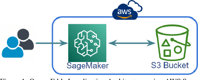
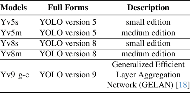
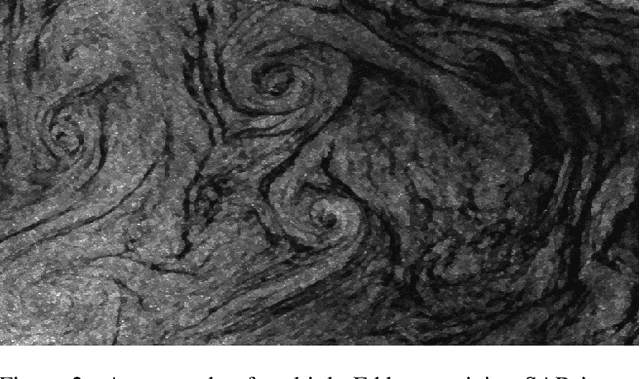
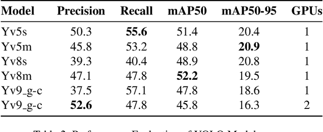
Ocean eddies play a significant role both on the sea surface and beneath it, contributing to the sustainability of marine life dependent on oceanic behaviors. Therefore, it is crucial to investigate ocean eddies to monitor changes in the Earth, particularly in the oceans, and their impact on climate. This study aims to pinpoint ocean eddies using AWS cloud services, specifically SageMaker. The primary objective is to detect small-scale (<20km) ocean eddies from satellite remote images and assess the feasibility of utilizing SageMaker, which offers tools for deploying AI applications. Moreover, this research not only explores the deployment of cloud-based services for remote sensing of Earth data but also evaluates several YOLO (You Only Look Once) models using single and multi-GPU-based services in the cloud. Furthermore, this study underscores the potential of these services, their limitations, challenges related to deployment and resource management, and their user-riendliness for Earth science projects.