 Add to Chrome
 Add to Firefox
 Add to Edge
Label-Efficient 3D Forest Mapping: Self-Supervised and Transfer Learning for Individual, Structural, and Species Analysis
Nov 09, 2025


Detailed structural and species information on individual tree level is increasingly important to support precision forestry, biodiversity conservation, and provide reference data for biomass and carbon mapping. Point clouds from airborne and ground-based laser scanning are currently the most suitable data source to rapidly derive such information at scale. Recent advancements in deep learning improved segmenting and classifying individual trees and identifying semantic tree components. However, deep learning models typically require large amounts of annotated training data which limits further improvement. Producing dense, high-quality annotations for 3D point clouds, especially in complex forests, is labor-intensive and challenging to scale. We explore strategies to reduce dependence on large annotated datasets using self-supervised and transfer learning architectures. Our objective is to improve performance across three tasks: instance segmentation, semantic segmentation, and tree classification using realistic and operational training sets. Our findings indicate that combining self-supervised learning with domain adaptation significantly enhances instance segmentation compared to training from scratch (AP50 +16.98%), self-supervised learning suffices for semantic segmentation (mIoU +1.79%), and hierarchical transfer learning enables accurate classification of unseen species (Jaccard +6.07%). To simplify use and encourage uptake, we integrated the tasks into a unified framework, streamlining the process from raw point clouds to tree delineation, structural analysis, and species classification. Pretrained models reduce energy consumption and carbon emissions by ~21%. This open-source contribution aims to accelerate operational extraction of individual tree information from laser scanning point clouds to support forestry, biodiversity, and carbon mapping.
Geospatial Foundation Models to Enable Progress on Sustainable Development Goals
May 30, 2025Foundation Models (FMs) are large-scale, pre-trained AI systems that have revolutionized natural language processing and computer vision, and are now advancing geospatial analysis and Earth Observation (EO). They promise improved generalization across tasks, scalability, and efficient adaptation with minimal labeled data. However, despite the rapid proliferation of geospatial FMs, their real-world utility and alignment with global sustainability goals remain underexplored. We introduce SustainFM, a comprehensive benchmarking framework grounded in the 17 Sustainable Development Goals with extremely diverse tasks ranging from asset wealth prediction to environmental hazard detection. This study provides a rigorous, interdisciplinary assessment of geospatial FMs and offers critical insights into their role in attaining sustainability goals. Our findings show: (1) While not universally superior, FMs often outperform traditional approaches across diverse tasks and datasets. (2) Evaluating FMs should go beyond accuracy to include transferability, generalization, and energy efficiency as key criteria for their responsible use. (3) FMs enable scalable, SDG-grounded solutions, offering broad utility for tackling complex sustainability challenges. Critically, we advocate for a paradigm shift from model-centric development to impact-driven deployment, and emphasize metrics such as energy efficiency, robustness to domain shifts, and ethical considerations.
HyperPointFormer: Multimodal Fusion in 3D Space with Dual-Branch Cross-Attention Transformers
May 29, 2025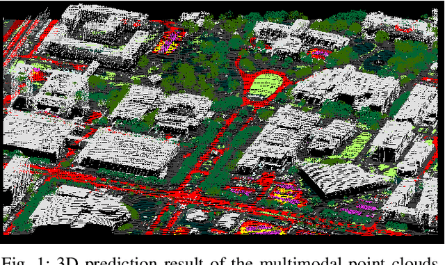
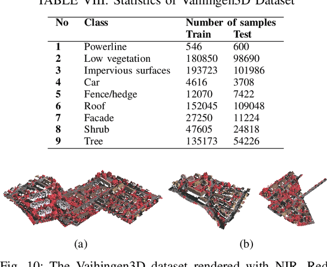
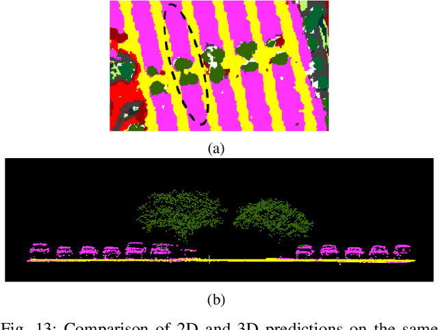
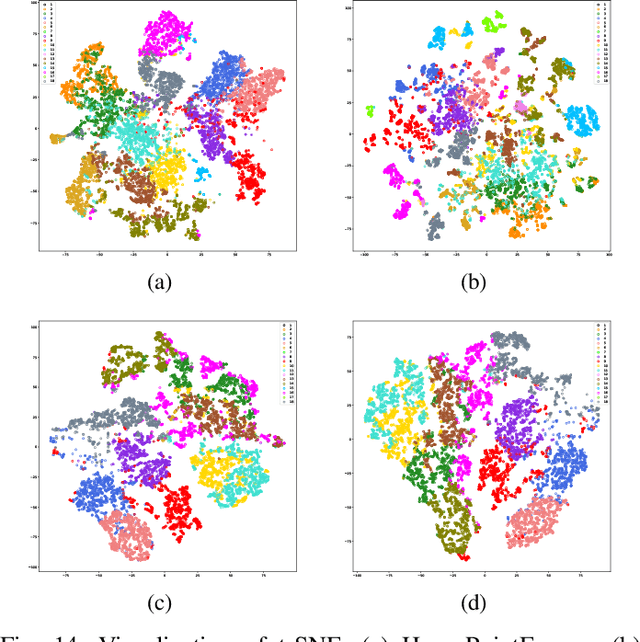
Multimodal remote sensing data, including spectral and lidar or photogrammetry, is crucial for achieving satisfactory land-use / land-cover classification results in urban scenes. So far, most studies have been conducted in a 2D context. When 3D information is available in the dataset, it is typically integrated with the 2D data by rasterizing the 3D data into 2D formats. Although this method yields satisfactory classification results, it falls short in fully exploiting the potential of 3D data by restricting the model's ability to learn 3D spatial features directly from raw point clouds. Additionally, it limits the generation of 3D predictions, as the dimensionality of the input data has been reduced. In this study, we propose a fully 3D-based method that fuses all modalities within the 3D point cloud and employs a dedicated dual-branch Transformer model to simultaneously learn geometric and spectral features. To enhance the fusion process, we introduce a cross-attention-based mechanism that fully operates on 3D points, effectively integrating features from various modalities across multiple scales. The purpose of cross-attention is to allow one modality to assess the importance of another by weighing the relevant features. We evaluated our method by comparing it against both 3D and 2D methods using the 2018 IEEE GRSS Data Fusion Contest (DFC2018) dataset. Our findings indicate that 3D fusion delivers competitive results compared to 2D methods and offers more flexibility by providing 3D predictions. These predictions can be projected onto 2D maps, a capability that is not feasible in reverse. Additionally, we evaluated our method on different datasets, specifically the ISPRS Vaihingen 3D and the IEEE 2019 Data Fusion Contest. Our code will be published here: https://github.com/aldinorizaldy/hyperpointformer.
Electrolyzers-HSI: Close-Range Multi-Scene Hyperspectral Imaging Benchmark Dataset
May 26, 2025


The global challenge of sustainable recycling demands automated, fast, and accurate, state-of-the-art (SOTA) material detection systems that act as a bedrock for a circular economy. Democratizing access to these cutting-edge solutions that enable real-time waste analysis is essential for scaling up recycling efforts and fostering the Green Deal. In response, we introduce \textbf{Electrolyzers-HSI}, a novel multimodal benchmark dataset designed to accelerate the recovery of critical raw materials through accurate electrolyzer materials classification. The dataset comprises 55 co-registered high-resolution RGB images and hyperspectral imaging (HSI) data cubes spanning the 400--2500 nm spectral range, yielding over 4.2 million pixel vectors and 424,169 labeled ones. This enables non-invasive spectral analysis of shredded electrolyzer samples, supporting quantitative and qualitative material classification and spectral properties investigation. We evaluate a suite of baseline machine learning (ML) methods alongside SOTA transformer-based deep learning (DL) architectures, including Vision Transformer, SpectralFormer, and the Multimodal Fusion Transformer, to investigate architectural bottlenecks for further efficiency optimisation when deploying transformers in material identification. We implement zero-shot detection techniques and majority voting across pixel-level predictions to establish object-level classification robustness. In adherence to the FAIR data principles, the electrolyzers-HSI dataset and accompanying codebase are openly available at https://github.com/hifexplo/Electrolyzers-HSI and https://rodare.hzdr.de/record/3668, supporting reproducible research and facilitating the broader adoption of smart and sustainable e-waste recycling solutions.
MineNetCD: A Benchmark for Global Mining Change Detection on Remote Sensing Imagery
Jul 04, 2024


Monitoring changes triggered by mining activities is crucial for industrial controlling, environmental management and regulatory compliance, yet it poses significant challenges due to the vast and often remote locations of mining sites. Remote sensing technologies have increasingly become indispensable to detect and analyze these changes over time. We thus introduce MineNetCD, a comprehensive benchmark designed for global mining change detection using remote sensing imagery. The benchmark comprises three key contributions. First, we establish a global mining change detection dataset featuring more than 70k paired patches of bi-temporal high-resolution remote sensing images and pixel-level annotations from 100 mining sites worldwide. Second, we develop a novel baseline model based on a change-aware Fast Fourier Transform (ChangeFFT) module, which enhances various backbones by leveraging essential spectrum components within features in the frequency domain and capturing the channel-wise correlation of bi-temporal feature differences to learn change-aware representations. Third, we construct a unified change detection (UCD) framework that integrates over 13 advanced change detection models. This framework is designed for streamlined and efficient processing, utilizing the cloud platform hosted by HuggingFace. Extensive experiments have been conducted to demonstrate the superiority of the proposed baseline model compared with 12 state-of-the-art change detection approaches. Empirical studies on modularized backbones comprehensively confirm the efficacy of different representation learners on change detection. This contribution represents significant advancements in the field of remote sensing and change detection, providing a robust resource for future research and applications in global mining monitoring. Dataset and Codes are available via the link.
PCB-Vision: A Multiscene RGB-Hyperspectral Benchmark Dataset of Printed Circuit Boards
Jan 12, 2024


Addressing the critical theme of recycling electronic waste (E-waste), this contribution is dedicated to developing advanced automated data processing pipelines as a basis for decision-making and process control. Aligning with the broader goals of the circular economy and the United Nations (UN) Sustainable Development Goals (SDG), our work leverages non-invasive analysis methods utilizing RGB and hyperspectral imaging data to provide both quantitative and qualitative insights into the E-waste stream composition for optimizing recycling efficiency. In this paper, we introduce 'PCB-Vision'; a pioneering RGB-hyperspectral printed circuit board (PCB) benchmark dataset, comprising 53 RGB images of high spatial resolution paired with their corresponding high spectral resolution hyperspectral data cubes in the visible and near-infrared (VNIR) range. Grounded in open science principles, our dataset provides a comprehensive resource for researchers through high-quality ground truths, focusing on three primary PCB components: integrated circuits (IC), capacitors, and connectors. We provide extensive statistical investigations on the proposed dataset together with the performance of several state-of-the-art (SOTA) models, including U-Net, Attention U-Net, Residual U-Net, LinkNet, and DeepLabv3+. By openly sharing this multi-scene benchmark dataset along with the baseline codes, we hope to foster transparent, traceable, and comparable developments of advanced data processing across various scientific communities, including, but not limited to, computer vision and remote sensing. Emphasizing our commitment to supporting a collaborative and inclusive scientific community, all materials, including code, data, ground truth, and masks, will be accessible at https://github.com/hifexplo/PCBVision.
TSGAN: An Optical-to-SAR Dual Conditional GAN for Optical based SAR Temporal Shifting
Jan 04, 2024In contrast to the well-investigated field of SAR-to-Optical translation, this study explores the lesser-investigated domain of Optical-to-SAR translation, a challenging field due to the ill-posed nature of this translation. The complexity arises as a single optical data can have multiple SAR representations based on the SAR viewing geometry. We propose a novel approach, termed SAR Temporal Shifting, which inputs an optical data from the desired timestamp along with a SAR data from a different temporal point but with a consistent viewing geometry as the expected SAR data, both complemented with a change map of optical data during the intervening period. This model modifies the SAR data based on the changes observed in optical data to generate the SAR data for the desired timestamp. Our model, a dual conditional Generative Adversarial Network (GAN), named Temporal Shifting GAN (TSGAN), incorporates a siamese encoder in both the Generator and the Discriminator. To prevent the model from overfitting on the input SAR data, we employed a change weighted loss function. Our approach surpasses traditional translation methods by eliminating the GAN's fiction phenomenon, particularly in unchanged regions, resulting in higher SSIM and PSNR in these areas. Additionally, modifications to the Pix2Pix architecture and the inclusion of attention mechanisms have enhanced the model's performance on all regions of the data. This research paves the way for leveraging legacy optical datasets, the most abundant and longstanding source of Earth imagery data, extending their use to SAR domains and temporal analyses. To foster further research, we provide the code, datasets used in our study, and a framework for generating paired SAR-Optical datasets for new regions of interest. These resources are available on github.com/moienr/TemporalGAN
Masking Hyperspectral Imaging Data with Pretrained Models
Nov 06, 2023


The presence of undesired background areas associated with potential noise and unknown spectral characteristics degrades the performance of hyperspectral data processing. Masking out unwanted regions is key to addressing this issue. Processing only regions of interest yields notable improvements in terms of computational costs, required memory, and overall performance. The proposed processing pipeline encompasses two fundamental parts: regions of interest mask generation, followed by the application of hyperspectral data processing techniques solely on the newly masked hyperspectral cube. The novelty of our work lies in the methodology adopted for the preliminary image segmentation. We employ the Segment Anything Model (SAM) to extract all objects within the dataset, and subsequently refine the segments with a zero-shot Grounding Dino object detector, followed by intersection and exclusion filtering steps, without the need for fine-tuning or retraining. To illustrate the efficacy of the masking procedure, the proposed method is deployed on three challenging applications scenarios that demand accurate masking; shredded plastics characterization, drill core scanning, and litter monitoring. The numerical evaluation of the proposed masking method on the three applications is provided along with the used hyperparameters. The scripts for the method will be available at https://github.com/hifexplo/Masking.
A Multisensor Hyperspectral Benchmark Dataset For Unmixing of Intimate Mixtures
Aug 30, 2023


Optical hyperspectral cameras capture the spectral reflectance of materials. Since many materials behave as heterogeneous intimate mixtures with which each photon interacts differently, the relationship between spectral reflectance and material composition is very complex. Quantitative validation of spectral unmixing algorithms requires high-quality ground truth fractional abundance data, which are very difficult to obtain. In this work, we generated a comprehensive laboratory ground truth dataset of intimately mixed mineral powders. For this, five clay powders (Kaolin, Roof clay, Red clay, mixed clay, and Calcium hydroxide) were mixed homogeneously to prepare 325 samples of 60 binary, 150 ternary, 100 quaternary, and 15 quinary mixtures. Thirteen different hyperspectral sensors have been used to acquire the reflectance spectra of these mixtures in the visible, near, short, mid, and long-wavelength infrared regions (350-15385) nm. {\color{black} Overlaps in wavelength regions due to the operational ranges of each sensor} and variations in acquisition conditions {\color{black} resulted in} a large amount of spectral variability. Ground truth composition is given by construction, but to verify that the generated samples are sufficiently homogeneous, XRD and XRF elemental analysis is performed. We believe these data will be beneficial for validating advanced methods for nonlinear unmixing and material composition estimation, including studying spectral variability and training supervised unmixing approaches. The datasets can be downloaded from the following link: https://github.com/VisionlabUA/Multisensor_datasets.
Tinto: Multisensor Benchmark for 3D Hyperspectral Point Cloud Segmentation in the Geosciences
May 17, 2023


The increasing use of deep learning techniques has reduced interpretation time and, ideally, reduced interpreter bias by automatically deriving geological maps from digital outcrop models. However, accurate validation of these automated mapping approaches is a significant challenge due to the subjective nature of geological mapping and the difficulty in collecting quantitative validation data. Additionally, many state-of-the-art deep learning methods are limited to 2D image data, which is insufficient for 3D digital outcrops, such as hyperclouds. To address these challenges, we present Tinto, a multi-sensor benchmark digital outcrop dataset designed to facilitate the development and validation of deep learning approaches for geological mapping, especially for non-structured 3D data like point clouds. Tinto comprises two complementary sets: 1) a real digital outcrop model from Corta Atalaya (Spain), with spectral attributes and ground-truth data, and 2) a synthetic twin that uses latent features in the original datasets to reconstruct realistic spectral data (including sensor noise and processing artifacts) from the ground-truth. The point cloud is dense and contains 3,242,964 labeled points. We used these datasets to explore the abilities of different deep learning approaches for automated geological mapping. By making Tinto publicly available, we hope to foster the development and adaptation of new deep learning tools for 3D applications in Earth sciences. The dataset can be accessed through this link: https://doi.org/10.14278/rodare.2256.