 Add to Chrome
 Add to Firefox
 Add to Edge
Distributed Coordination for Resilient Multi-UAV Remote Sensing: A Photovoltaic Inspection Case Study
Jul 27, 2026
Deploying multiple UAVs for remote sensing enables proportional reductions in mission time, but realizing these benefits requires the fleet to coordinate at runtime: distributing sensing targets, responding to platform failures, and recovering from degraded data quality. In inspection campaigns, where mission value depends on complete coverage and the usability of every capture, a centralized ground-station coordinator is a single point of failure: a lost link or station fault leaves sensing gaps that cannot be filled without operator intervention. We propose the \textbf{SwarmLink}, an inter-agent communication infrastructure that non-invasively extends any existing aerial framework with peer-to-peer coordination capability, without modifying the host system. We apply it to photovoltaic plant inspection as a representative large-scale sensing campaign, extending Aerostack2 with a distributed auction that unifies initial sensing-target allocation, platform-failure recovery, and data-quality-triggered reassignment into a single runtime mechanism. All three disruption scenarios reduce to the same re-auction over remaining targets and active platforms, requiring zero modifications to the Aerostack2 core and no ground-station involvement during the mission.

Flight-Ready LiDAR-Inertial Odometry for Embedded Drone Platforms
Jul 24, 2026Open-source LiDAR-inertial odometry (LIO) systems have achieved remarkable benchmark accuracy, yet current state-of-the-art implementations are primarily optimized for evaluation performance rather than the requirements of real-time closed-loop aerial control. When deployed onboard UAVs, this can introduce limitations that degrade flight performance. In this work, we identify five architectural deficiencies in a representative tightly coupled IESKF-based LIO implementation: odometry publishing tied to the LiDAR rate (10 Hz instead of the IMU's 200 Hz), missing velocity outputs, execution bottlenecks that block IMU processing, mutex contention, and synchronization race conditions. We introduce corresponding modifications including IMU-rate forward propagation, direct body-frame velocity publishing, SLERP-based smoothing, dual-executor isolation, and explicit synchronization protection. The resulting system increases odometry output from ~10 Hz to a stable 200 Hz, provides a complete Twist state at every IMU sample, and preserves continuity during transient LiDAR loss. Experiments on a Livox Mid-360 / Pixhawk 4 Mini autonomous UAV with motion-capture ground truth validate the approach. Since the underlying estimator (IESKF + ikd-Tree) remains unchanged, the proposed improvements can be directly applied to FAST-LIO2-derived implementations.
REMIND: RE-Identification with Memory for INDoor Navigation
Jul 10, 2026Mobile robots operating indoors must re-identify previously observed objects after long temporal gaps, significant viewpoint changes, and severe illumination variations. This remains a challenging problem: multi-object tracking methods are optimized for short-term association of pedestrians and vehicles at video rates, person and vehicle re-identification approaches lack persistent memory mechanisms, and state-of-the-art video object segmentation techniques rely on reactive distractor filtering rather than enforcing global identity consistency. To address these limitations, we present REMIND, an online tracker designed for long-term multi-object re-identification of generic indoor objects from monocular RGB imagery, requiring neither camera pose nor depth. Motivated by evidence from visual cognition that humans rely on accumulated appearance familiarity and spatial context rather than explicit self-localization, REMIND combines frozen DINOv3 features with a dual-bank multi-prototype appearance memory, part- and background-level descriptors, a neighbour-context reasoning module exploiting spatial co-occurrence, and joint Hungarian assignment with ambiguity-aware safeguards. On a purpose-built indoor dataset featuring controlled revisits and dense same-class clutter, REMIND reaches 90.35% IDF1, nearly 20 points above a state-of-the-art video object segmentation baseline and more than 36 above a strong tracking-by-detection baseline. On ScanNet++, it attains the highest IDF1 in every setting but one, end-to-end detection over all scenes, where the tracking-by-detection baseline is marginally ahead while REMIND still associates and recovers identities more accurately; it also completes every scene, whereas the video object segmentation baseline exhausts GPU memory on 66.9% under YOLO detections. The complete system, evaluation framework, and dataset are publicly released.
Robust Graph Matching through Semantic Relationship Generation for SLAM
Apr 28, 2026Graph-based representations such as Scene Graphs enable localization in structured indoor environments by matching a locally observed graph, constructed from sensor data, to a prior map. This process is particularly challenging in environments with repetitive or symmetric layouts, where structural cues alone are often insufficient to resolve ambiguities. We propose a semantic-enhanced graph matching approach that explicitly models relations between detected objects and structural elements, such as rooms and wall planes. Objects are detected from RGB-D data and integrated into the graph, and their relations to structural elements are exploited to filter candidate correspondences prior to geometric verification, significantly reducing ambiguity and search complexity. The proposed method is integrated within the iS-Graphs framework and evaluated in synthetic and simulated environments. Results show that semantic relations significantly reduce the number of candidate matches, improve computational efficiency, and enable faster convergence, particularly in symmetric scenarios where purely geometric approaches fail.
Dual Pose-Graph Semantic Localization for Vision-Based Autonomous Drone Racing
Apr 16, 2026Autonomous drone racing demands robust real-time localization under extreme conditions: high-speed flight, aggressive maneuvers, and payload-constrained platforms that often rely on a single camera for perception. Existing visual SLAM systems, while effective in general scenarios, struggle with motion blur and feature instability inherent to racing dynamics, and do not exploit the structured nature of racing environments. In this work, we present a dual pose-graph architecture that fuses odometry with semantic detections for robust localization. A temporary graph accumulates multiple gate observations between keyframes and optimizes them into a single refined constraint per landmark, which is then promoted to a persistent main graph. This design preserves the information richness of frequent detections while preventing graph growth from degrading real-time performance. The system is designed to be sensor-agnostic, although in this work we validate it using monocular visual-inertial odometry and visual gate detections. Experimental evaluation on the TII-RATM dataset shows a 56% to 74% reduction in ATE compared to standalone VIO, while an ablation study confirms that the dual-graph architecture achieves 10% to 12% higher accuracy than a single-graph baseline at identical computational cost. Deployment in the A2RL competition demonstrated that the system performs real-time onboard localization during flight, reducing the drift of the odometry baseline by up to 4.2 m per lap.
Flocking behavior for dynamic and complex swarm structures
Jan 29, 2026Maintaining the formation of complex structures with multiple UAVs and achieving complex trajectories remains a major challenge. This work presents an algorithm for implementing the flocking behavior of UAVs based on the concept of Virtual Centroid to easily develop a structure for the flock. The approach builds on the classical virtual-based behavior, providing a theoretical framework for incorporating enhancements to dynamically control both the number of agents and the formation of the structure. Simulation tests and real-world experiments were conducted, demonstrating its simplicity even with complex formations and complex trajectories.
A Methodology for Designing Knowledge-Driven Missions for Robots
Jan 28, 2026This paper presents a comprehensive methodology for implementing knowledge graphs in ROS 2 systems, aiming to enhance the efficiency and intelligence of autonomous robotic missions. The methodology encompasses several key steps: defining initial and target conditions, structuring tasks and subtasks, planning their sequence, representing task-related data in a knowledge graph, and designing the mission using a high-level language. Each step builds on the previous one to ensure a cohesive process from initial setup to final execution. A practical implementation within the Aerostack2 framework is demonstrated through a simulated search and rescue mission in a Gazebo environment, where drones autonomously locate a target. This implementation highlights the effectiveness of the methodology in improving decision-making and mission performance by leveraging knowledge graphs.
Exploring Unstructured Environments using Minimal Sensing on Cooperative Nano-Drones
Jul 09, 2024
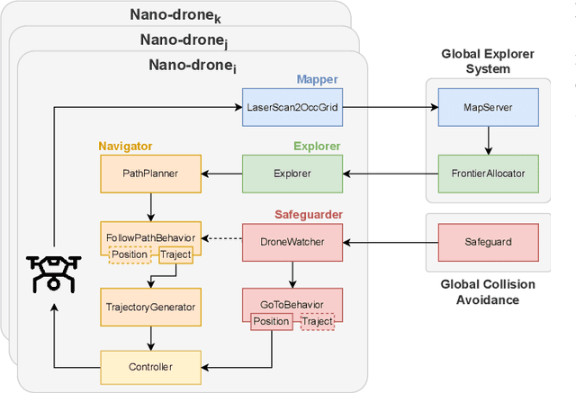


Recent advances have improved autonomous navigation and mapping under payload constraints, but current multi-robot inspection algorithms are unsuitable for nano-drones due to their need for heavy sensors and high computational resources. To address these challenges, we introduce ExploreBug, a novel hybrid frontier range bug algorithm designed to handle limited sensing capabilities for a swarm of nano-drones. This system includes three primary components: a mapping subsystem, an exploration subsystem, and a navigation subsystem. Additionally, an intra-swarm collision avoidance system is integrated to prevent collisions between drones. We validate the efficacy of our approach through extensive simulations and real-world exploration experiments involving up to seven drones in simulations and three in real-world settings, across various obstacle configurations and with a maximum navigation speed of 0.75 m/s. Our tests demonstrate that the algorithm efficiently completes exploration tasks, even with minimal sensing, across different swarm sizes and obstacle densities. Furthermore, our frontier allocation heuristic ensures an equal distribution of explored areas and paths traveled by each drone in the swarm. We publicly release the source code of the proposed system to foster further developments in mapping and exploration using autonomous nano drones.
The landscape of Collective Awareness in multi-robot systems
Jan 17, 2024The development of collective-aware multi-robot systems is crucial for enhancing the efficiency and robustness of robotic applications in multiple fields. These systems enable collaboration, coordination, and resource sharing among robots, leading to improved scalability, adaptability to dynamic environments, and increased overall system robustness. In this work, we want to provide a brief overview of this research topic and identify open challenges.
Multi S-Graphs: an Efficient Real-time Distributed Semantic-Relational Collaborative SLAM
Jan 10, 2024Collaborative Simultaneous Localization and Mapping (CSLAM) is critical to enable multiple robots to operate in complex environments. Most CSLAM techniques rely on raw sensor measurement or low-level features such as keyframe descriptors, which can lead to wrong loop closures due to the lack of deep understanding of the environment. Moreover, the exchange of these measurements and low-level features among the robots requires the transmission of a significant amount of data, which limits the scalability of the system. To overcome these limitations, we present Multi S-Graphs, a decentralized CSLAM system that utilizes high-level semantic-relational information embedded in the four-layered hierarchical and optimizable situational graphs for cooperative map generation and localization while minimizing the information exchanged between the robots. To support this, we present a novel room-based descriptor which, along with its connected walls, is used to perform inter-robot loop closures, addressing the challenges of multi-robot kidnapped problem initialization. Multiple experiments in simulated and real environments validate the improvement in accuracy and robustness of the proposed approach while reducing the amount of data exchanged between robots compared to other state-of-the-art approaches. Software available within a docker image: https://github.com/snt-arg/multi_s_graphs_docker