 Add to Chrome
 Add to Firefox
 Add to Edge
From Language to Navigation Goals: A Vision-Language Approach for Semantic Navigation of Mobile Robots Using RGB-D Perception
Jul 15, 2026
Natural language interaction provides an intuitive way for non-expert users to communicate with robotic platforms. However, transforming user requests into executable navigation actions remains a challenging task, requiring the integration of language understanding, environment perception, and autonomous navigation. This work presents a language-driven navigation framework that enables mobile robots to interpret user requests in natural language to move the robot to a destination and autonomously navigate towards it. The framework is composed of modular ROS 2 components that cooperate to transform natural language instructions into navigation actions. Given a natural language request referring to a target in the environment (e.g., "go to the mail box"), the system identifies the referenced object, estimates its position using RGB-D data, and generates a navigation goal, which is then executed through the ROS 2 Nav2 navigation stack. The ROS 2-based implementation facilitates portability across different robotic platforms, requiring only the configuration of the corresponding topics and services. The system is evaluated in both simulation and real-world scenarios using a TurtleBot3 Waffle and a Unitree Go2 robot with a RealSense camera. Experimental results show that the framework successfully interprets both direct commands and contextual requests, generates meaningful natural-language feedback, and navigates towards the desired target. These results demonstrate the feasibility of combining semantic perception and autonomous navigation to provide an intuitive human-robot interaction paradigm. Code will be released as open source upon acceptance.

Navigating the Crowd: Non-linear MPC with Social Forces Dynamics for Human-Aware Robot Navigation
Jul 11, 2026Safe and socially compliant navigation remains a fundamental challenge for autonomous robots operating in human-populated environments. Beyond collision avoidance, robots must anticipate human motion and respect personal space to ensure human comfort. Model Predictive Control (MPC) offers a robust alternative to classical and data-driven methods, although its effectiveness strongly depends on accurate human motion prediction and efficient computation. This paper introduces SFM-NMPC, a Social Force Model-based Non-linear Model Predictive Control framework that embeds human motion prediction directly within the optimization loop. By incorporating the Social Force Model into the dynamic model of surrounding agents, the controller jointly predicts the trajectories of humans and robots over the prediction horizon, thereby enabling socially-aware planning. A tailored set of social cost functions guides the optimization toward human-compliant behaviors. Despite the increased model complexity, the proposed formulation runs in real time at 20 Hz. Extensive simulated testing in crowded environments demonstrates that SFM-NMPC outperforms state-of-the-art baselines in social compliance metrics while maintaining efficient and smooth navigation. Visual trajectory analysis and an ablation study further highlight the contribution of the embedded SFM dynamics and social cost terms, confirming the effectiveness of the proposed approach for real-world social navigation.
4D Radar Gaussian Modeling and Scan Matching with RCS
Apr 16, 20264D millimeter-wave (mmWave) radars are increasingly used in robotics, as they offer robustness against adverse environmental conditions. Besides the usual XYZ position, they provide Doppler velocity measurements as well as Radar Cross Section (RCS) information for every point. While Doppler is widely used to filter out dynamic points, RCS is often overlooked and not usually used in modeling and scan matching processes. Building on previous 3D Gaussian modeling and scan matching work, we propose incorporating the physical behavior of RCS in the model, in order to further enrich the summarized information about the scene, and improve the scan matching process.
G-EDF-Loc: 3D Continuous Gaussian Distance Field for Robust Gradient-Based 6DoF Localization
Apr 06, 2026This paper presents a robust 6-DoF localization framework based on a direct, CPU-based scan-to-map registration pipeline. The system leverages G-EDF, a novel continuous and memory-efficient 3D distance field representation. The approach models the Euclidean Distance Field (EDF) using a Block-Sparse Gaussian Mixture Model with adaptive spatial partitioning, ensuring $C^1$ continuity across block transitions and mitigating boundary artifacts. By leveraging the analytical gradients of this continuous map, which maintain Eikonal consistency, the proposed method achieves high-fidelity spatial reconstruction and real-time localization. Experimental results on large-scale datasets demonstrate that G-EDF-Loc performs competitively against state-of-the-art methods, exhibiting exceptional resilience even under severe odometry degradation or in the complete absence of IMU priors.
Radio-based Multi-Robot Odometry and Relative Localization
Sep 30, 2025Radio-based methods such as Ultra-Wideband (UWB) and RAdio Detection And Ranging (radar), which have traditionally seen limited adoption in robotics, are experiencing a boost in popularity thanks to their robustness to harsh environmental conditions and cluttered environments. This work proposes a multi-robot UGV-UAV localization system that leverages the two technologies with inexpensive and readily-available sensors, such as Inertial Measurement Units (IMUs) and wheel encoders, to estimate the relative position of an aerial robot with respect to a ground robot. The first stage of the system pipeline includes a nonlinear optimization framework to trilaterate the location of the aerial platform based on UWB range data, and a radar pre-processing module with loosely coupled ego-motion estimation which has been adapted for a multi-robot scenario. Then, the pre-processed radar data as well as the relative transformation are fed to a pose-graph optimization framework with odometry and inter-robot constraints. The system, implemented for the Robotic Operating System (ROS 2) with the Ceres optimizer, has been validated in Software-in-the-Loop (SITL) simulations and in a real-world dataset. The proposed relative localization module outperforms state-of-the-art closed-form methods which are less robust to noise. Our SITL environment includes a custom Gazebo plugin for generating realistic UWB measurements modeled after real data. Conveniently, the proposed factor graph formulation makes the system readily extensible to full Simultaneous Localization And Mapping (SLAM). Finally, all the code and experimental data is publicly available to support reproducibility and to serve as a common open dataset for benchmarking.
HuNavSim 2.0
Jul 23, 2025This work presents a new iteration of the Human Navigation Simulator (HuNavSim), a novel open-source tool for the simulation of different human-agent navigation behaviors in scenarios with mobile robots. The tool, programmed under the ROS 2 framework, can be used together with different well-known robotics simulators such as Gazebo or NVidia Isaac Sim. The main goal is to facilitate the development and evaluation of human-aware robot navigation systems in simulation. In this new version, several features have been improved and new ones added, such as the extended set of actions and conditions that can be combined in Behavior Trees to compound complex and realistic human behaviors.
Long Duration Inspection of GNSS-Denied Environments with a Tethered UAV-UGV Marsupial System
May 29, 2025Unmanned Aerial Vehicles (UAVs) have become essential tools in inspection and emergency response operations due to their high maneuverability and ability to access hard-to-reach areas. However, their limited battery life significantly restricts their use in long-duration missions. This paper presents a novel tethered marsupial robotic system composed of a UAV and an Unmanned Ground Vehicle (UGV), specifically designed for autonomous, long-duration inspection tasks in Global Navigation Satellite System (GNSS)-denied environments. The system extends the UAV's operational time by supplying power through a tether connected to high-capacity battery packs carried by the UGV. We detail the hardware architecture based on off-the-shelf components to ensure replicability and describe our full-stack software framework, which is composed of open-source components and built upon the Robot Operating System (ROS). The proposed software architecture enables precise localization using a Direct LiDAR Localization (DLL) method and ensures safe path planning and coordinated trajectory tracking for the integrated UGV-tether-UAV system. We validate the system through three field experiments: (1) a manual flight endurance test to estimate the operational duration, (2) an autonomous navigation test, and (3) an inspection mission to demonstrate autonomous inspection capabilities. Experimental results confirm the robustness and autonomy of the system, its capacity to operate in GNSS-denied environments, and its potential for long-endurance, autonomous inspection and monitoring tasks.
4D Radar-Inertial Odometry based on Gaussian Modeling and Multi-Hypothesis Scan Matching
Dec 18, 2024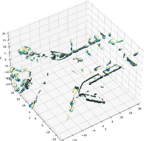
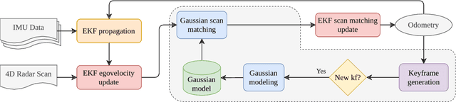
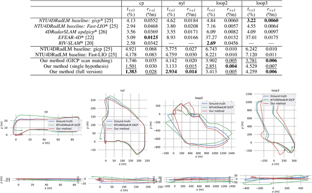

4D millimeter-wave (mmWave) radars are sensors that provide robustness against adverse weather conditions (rain, snow, fog, etc.), and as such they are increasingly being used for odometry and SLAM applications. However, the noisy and sparse nature of the returned scan data proves to be a challenging obstacle for existing point cloud matching based solutions, especially those originally intended for more accurate sensors such as LiDAR. Inspired by visual odometry research around 3D Gaussian Splatting, in this paper we propose using freely positioned 3D Gaussians to create a summarized representation of a radar point cloud tolerant to sensor noise, and subsequently leverage its inherent probability distribution function for registration (similar to NDT). Moreover, we propose simultaneously optimizing multiple scan matching hypotheses in order to further increase the robustness of the system against local optima of the function. Finally, we fuse our Gaussian modeling and scan matching algorithms into an EKF radar-inertial odometry system designed after current best practices. Experiments show that our Gaussian-based odometry is able to outperform current baselines on a well-known 4D radar dataset used for evaluation.
Physical simulation of Marsupial UAV-UGV Systems Connected by a Hanging Tether using Gazebo
Dec 17, 2024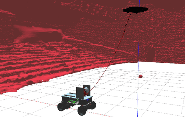
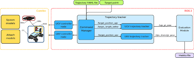
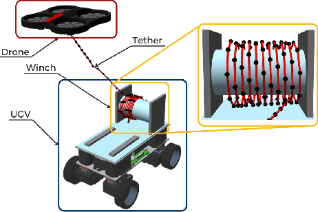

This paper presents a ROS 2-based simulator framework for tethered UAV-UGV marsupial systems in Gazebo. The framework models interactions among a UAV, a UGV, and a winch with dynamically adjustable length and slack of the tether. It supports both manual control and automated trajectory tracking, with the winch adjusting the length of the tether based on the relative distance between the robots. The simulator's performance is demonstrated through experiments, including comparisons with real-world data, showcasing its capability to simulate tethered robotic systems. The framework offers a flexible tool for researchers exploring tethered robot dynamics. The source code of the simulator is publicly available for the research community.
Loosely coupled 4D-Radar-Inertial Odometry for Ground Robots
Nov 26, 2024Accurate robot odometry is essential for autonomous navigation. While numerous techniques have been developed based on various sensor suites, odometry estimation using only radar and IMU remains an underexplored area. Radar proves particularly valuable in environments where traditional sensors, like cameras or LiDAR, may struggle, especially in low-light conditions or when faced with environmental challenges like fog, rain or smoke. However, despite its robustness, radar data is noisier and more prone to outliers, requiring specialized processing approaches. In this paper, we propose a graph-based optimization approach using a sliding window for radar-based odometry, designed to maintain robust relationships between poses by forming a network of connections, while keeping computational costs fixed (specially beneficial in long trajectories). Additionally, we introduce an enhancement in the ego-velocity estimation specifically for ground vehicles, both holonomic and non-holonomic, which subsequently improves the direct odometry input required by the optimizer. Finally, we present a comparative study of our approach against existing algorithms, showing how our pure odometry approach inproves the state of art in most trajectories of the NTU4DRadLM dataset, achieving promising results when evaluating key performance metrics.