 Add to Chrome
 Add to Firefox
 Add to Edge
Robust Graph Matching through Semantic Relationship Generation for SLAM
Apr 28, 2026
Graph-based representations such as Scene Graphs enable localization in structured indoor environments by matching a locally observed graph, constructed from sensor data, to a prior map. This process is particularly challenging in environments with repetitive or symmetric layouts, where structural cues alone are often insufficient to resolve ambiguities. We propose a semantic-enhanced graph matching approach that explicitly models relations between detected objects and structural elements, such as rooms and wall planes. Objects are detected from RGB-D data and integrated into the graph, and their relations to structural elements are exploited to filter candidate correspondences prior to geometric verification, significantly reducing ambiguity and search complexity. The proposed method is integrated within the iS-Graphs framework and evaluated in synthetic and simulated environments. Results show that semantic relations significantly reduce the number of candidate matches, improve computational efficiency, and enable faster convergence, particularly in symmetric scenarios where purely geometric approaches fail.

COMPASS: COmpact Multi-channel Prior-map And Scene Signature for Floor-Plan-Based Visual Localization
Apr 28, 2026Architectural floor plans are widely available priors which contain not only geometry but also the semantic information of the environment, yet existing localization methods largely ignore this semantic information. To address this, we present COMPASS, an algorithm that exploits both geometric and semantic priors from floor plans to estimate the pose of a robot equipped with dual fisheye cameras. Inspired by scan context descriptor from LiDAR-based place recognition, we design a multi-channel radial descriptor that encodes the geometric layout surrounding a position. From the floor plan, rays are cast in 360 azimuth bins and the results are encoded into five channels: normalized range, structural hit type (wall, window, or opening), range gradient, inverse range, and local range variance. From the image side, the same descriptor structure is populated by detecting structural elements in the fisheye imagery. As a first step toward full cross-modal matching, we present a window detection algorithm for fisheye images that uses a line segment detector to identify window frames via vertical edge clustering and brightness verification. Detected windows are projected to azimuthal bearings through the fisheye camera model, producing the hit-type channel of the visual descriptor. As a proof of concept, we generate both descriptors at a single known pose from the Hilti-Trimble SLAM Challenge 2026 dataset and demonstrate that the wall-window pattern extracted from the first frame of each camera closely matches the floor plan descriptor, validating the feasibility of cross-modal structural matching.
Passage-Aware Structural Mapping for RGB-D Visual SLAM
Apr 27, 2026Doorways and passages are critical structural elements for indoor robot navigation, yet they remain underexplored in modern Visual SLAM (VSLAM) frameworks. This paper presents a passage-aware structural mapping approach for RGB-D VSLAM that detects doors and traversable openings by jointly fusing geometric, semantic, and topological cues. Doors are modeled as planar entities embedded within walls and classified as traversable or non-traversable based on their coplanarity with the supporting wall. Passages are inferred through two complementary strategies: traversal evidence accumulated from camera-wall interactions across consecutive keyframes, and geometric opening validation based on discontinuities in the mapped wall geometry. The proposed method is integrated into vS-Graphs as a proof of concept, enriching its scene graph with passage-level abstractions and improving room connectivity modeling. Qualitative evaluations on indoor office sequences demonstrate reliable doorway detection, and the framework lays the foundation for exploiting these elements in BIM-informed VSLAM. The source code is publicly available at https://github.com/snt-arg/visual_sgraphs/tree/doorway_integration.
Dual Pose-Graph Semantic Localization for Vision-Based Autonomous Drone Racing
Apr 16, 2026Autonomous drone racing demands robust real-time localization under extreme conditions: high-speed flight, aggressive maneuvers, and payload-constrained platforms that often rely on a single camera for perception. Existing visual SLAM systems, while effective in general scenarios, struggle with motion blur and feature instability inherent to racing dynamics, and do not exploit the structured nature of racing environments. In this work, we present a dual pose-graph architecture that fuses odometry with semantic detections for robust localization. A temporary graph accumulates multiple gate observations between keyframes and optimizes them into a single refined constraint per landmark, which is then promoted to a persistent main graph. This design preserves the information richness of frequent detections while preventing graph growth from degrading real-time performance. The system is designed to be sensor-agnostic, although in this work we validate it using monocular visual-inertial odometry and visual gate detections. Experimental evaluation on the TII-RATM dataset shows a 56% to 74% reduction in ATE compared to standalone VIO, while an ablation study confirms that the dual-graph architecture achieves 10% to 12% higher accuracy than a single-graph baseline at identical computational cost. Deployment in the A2RL competition demonstrated that the system performs real-time onboard localization during flight, reducing the drift of the odometry baseline by up to 4.2 m per lap.
Flocking behavior for dynamic and complex swarm structures
Jan 29, 2026Maintaining the formation of complex structures with multiple UAVs and achieving complex trajectories remains a major challenge. This work presents an algorithm for implementing the flocking behavior of UAVs based on the concept of Virtual Centroid to easily develop a structure for the flock. The approach builds on the classical virtual-based behavior, providing a theoretical framework for incorporating enhancements to dynamically control both the number of agents and the formation of the structure. Simulation tests and real-world experiments were conducted, demonstrating its simplicity even with complex formations and complex trajectories.
A Methodology for Designing Knowledge-Driven Missions for Robots
Jan 28, 2026This paper presents a comprehensive methodology for implementing knowledge graphs in ROS 2 systems, aiming to enhance the efficiency and intelligence of autonomous robotic missions. The methodology encompasses several key steps: defining initial and target conditions, structuring tasks and subtasks, planning their sequence, representing task-related data in a knowledge graph, and designing the mission using a high-level language. Each step builds on the previous one to ensure a cohesive process from initial setup to final execution. A practical implementation within the Aerostack2 framework is demonstrated through a simulated search and rescue mission in a Gazebo environment, where drones autonomously locate a target. This implementation highlights the effectiveness of the methodology in improving decision-making and mission performance by leveraging knowledge graphs.
Human Interaction for Collaborative Semantic SLAM using Extended Reality
Sep 18, 2025Semantic SLAM (Simultaneous Localization and Mapping) systems enrich robot maps with structural and semantic information, enabling robots to operate more effectively in complex environments. However, these systems struggle in real-world scenarios with occlusions, incomplete data, or ambiguous geometries, as they cannot fully leverage the higher-level spatial and semantic knowledge humans naturally apply. We introduce HICS-SLAM, a Human-in-the-Loop semantic SLAM framework that uses a shared extended reality environment for real-time collaboration. The system allows human operators to directly interact with and visualize the robot's 3D scene graph, and add high-level semantic concepts (e.g., rooms or structural entities) into the mapping process. We propose a graph-based semantic fusion methodology that integrates these human interventions with robot perception, enabling scalable collaboration for enhanced situational awareness. Experimental evaluations on real-world construction site datasets demonstrate improvements in room detection accuracy, map precision, and semantic completeness compared to automated baselines, demonstrating both the effectiveness of the approach and its potential for future extensions.
BIM Informed Visual SLAM for Construction Monitoring
Sep 17, 2025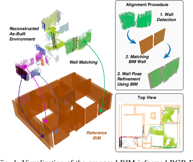
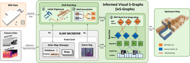
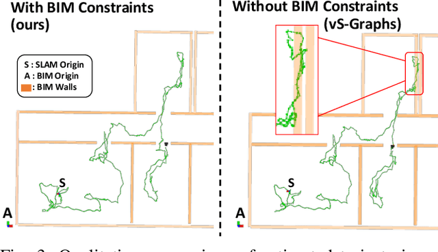
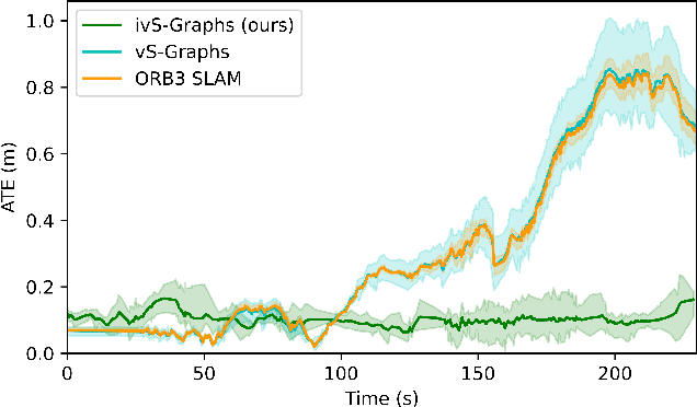
Simultaneous Localization and Mapping (SLAM) is a key tool for monitoring construction sites, where aligning the evolving as-built state with the as-planned design enables early error detection and reduces costly rework. LiDAR-based SLAM achieves high geometric precision, but its sensors are typically large and power-demanding, limiting their use on portable platforms. Visual SLAM offers a practical alternative with lightweight cameras already embedded in most mobile devices. however, visually mapping construction environments remains challenging: repetitive layouts, occlusions, and incomplete or low-texture structures often cause drift in the trajectory map. To mitigate this, we propose an RGB-D SLAM system that incorporates the Building Information Model (BIM) as structural prior knowledge. Instead of relying solely on visual cues, our system continuously establishes correspondences between detected wall and their BIM counterparts, which are then introduced as constraints in the back-end optimization. The proposed method operates in real time and has been validated on real construction sites, reducing trajectory error by an average of 23.71% and map RMSE by 7.14% compared to visual SLAM baselines. These results demonstrate that BIM constraints enable reliable alignment of the digital plan with the as-built scene, even under partially constructed conditions.
SMapper: A Multi-Modal Data Acquisition Platform for SLAM Benchmarking
Sep 11, 2025Advancing research in fields like Simultaneous Localization and Mapping (SLAM) and autonomous navigation critically depends on reliable and reproducible multimodal datasets. While several influential datasets have driven progress in these domains, they often suffer from limitations in sensing modalities, environmental diversity, and the reproducibility of the underlying hardware setups. To address these challenges, this paper introduces SMapper, a novel open-hardware, multi-sensor platform designed explicitly for, though not limited to, SLAM research. The device integrates synchronized LiDAR, multi-camera, and inertial sensing, supported by a robust calibration and synchronization pipeline that ensures precise spatio-temporal alignment across modalities. Its open and replicable design allows researchers to extend its capabilities and reproduce experiments across both handheld and robot-mounted scenarios. To demonstrate its practicality, we additionally release SMapper-light, a publicly available SLAM dataset containing representative indoor and outdoor sequences. The dataset includes tightly synchronized multimodal data and ground-truth trajectories derived from offline LiDAR-based SLAM with sub-centimeter accuracy, alongside dense 3D reconstructions. Furthermore, the paper contains benchmarking results on state-of-the-art LiDAR and visual SLAM frameworks using the SMapper-light dataset. By combining open-hardware design, reproducible data collection, and comprehensive benchmarking, SMapper establishes a robust foundation for advancing SLAM algorithm development, evaluation, and reproducibility.
Exploring Unstructured Environments using Minimal Sensing on Cooperative Nano-Drones
Jul 09, 2024
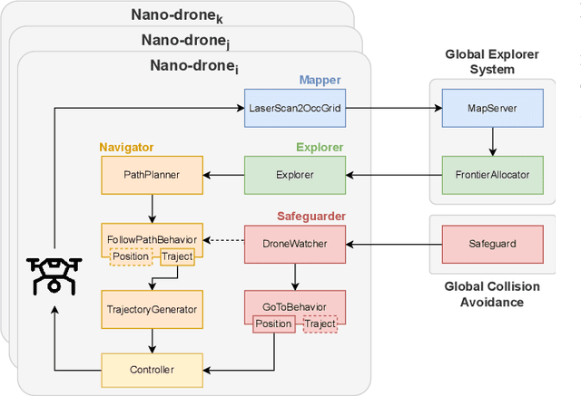


Recent advances have improved autonomous navigation and mapping under payload constraints, but current multi-robot inspection algorithms are unsuitable for nano-drones due to their need for heavy sensors and high computational resources. To address these challenges, we introduce ExploreBug, a novel hybrid frontier range bug algorithm designed to handle limited sensing capabilities for a swarm of nano-drones. This system includes three primary components: a mapping subsystem, an exploration subsystem, and a navigation subsystem. Additionally, an intra-swarm collision avoidance system is integrated to prevent collisions between drones. We validate the efficacy of our approach through extensive simulations and real-world exploration experiments involving up to seven drones in simulations and three in real-world settings, across various obstacle configurations and with a maximum navigation speed of 0.75 m/s. Our tests demonstrate that the algorithm efficiently completes exploration tasks, even with minimal sensing, across different swarm sizes and obstacle densities. Furthermore, our frontier allocation heuristic ensures an equal distribution of explored areas and paths traveled by each drone in the swarm. We publicly release the source code of the proposed system to foster further developments in mapping and exploration using autonomous nano drones.