 Add to Chrome
 Add to Firefox
 Add to Edge
GaussLite: Online Task-Conditioned 3D Gaussian Splatting for Real-Time Robotic Mapping
Jun 29, 2026
Existing 3D Gaussian Splatting (3DGS) systems distribute representation capacity uniformly across a scene, ignoring the fact that many downstream robotic tasks engage only a fraction of the reconstructed geometry. This causes valuable onboard compute to be allocated towards optimizing irrelevant parts of the scene, either limiting online capacity or under-optimizing the most relevant parts of the scene. We introduce GaussLite, a task-driven 3DGS mapping system that conditions its representation density on a natural-language task specification. Given a posed RGB-D stream and a task such as "prepare to pick up the object on the desk," GaussLite uses a one-shot LLM parser to extract target and anchor objects, which are grounded per-frame by an open-vocabulary detector and segmented to produce per-pixel relevance masks in real time. The mapper allocates seeding density, gradient flow and scaling by task relevance. At matched Gaussian budget and real-time mapping at 4 Hz on resource-constrained hardware, GaussLite outperforms baselines on ROI PSNR on the Replica Dataset by an average +2.72 dB and on a real-hardware demonstration in indoor and outdoor settings by +2.23 dB. We further show that two task-specialized agents' maps can be fused into a single shared map via per-voxel voting on active-optimization counts in real time, outperforming concatenation by +3.42 dB while only sharing an average 7.08% of the map.

Meridian: Metric-Semantic Primitive Matching for Cross-View Geo-Localization Beyond Urban Environments
Jun 04, 2026Successful robot automation requires accurate global localization to support repeatability, task planning, goal specification, and safe operation. However, reliable localization in GNSS-denied environments remains an open problem. Overhead aerial imagery offers a promising solution, but existing approaches primarily target structured urban environments and have been rarely demonstrated in unstructured natural terrain. Limitations of the state-of-the-art include a reliance on models trained for specific environments, as well as difficulty handling repetitive geometries and featureless landscapes commonly found in natural outdoor areas. To overcome these challenges, we present Meridian, a method for matching high-level metric-semantic primitives across aerial images and ground robot RGB-D camera data that achieves accurate global localization and generalizes well across diverse environments, all without any training or algorithmic fine-tuning on area-specific data. We formulate novel consistency metrics to estimate a distribution over robot submap poses and to reject outlier hypotheses in a robust pose graph optimization step for accurate robot trajectory estimation. We demonstrate that our algorithm can localize a ground robot across a wide variety of environments, including an autonomous driving dataset, a park and campus area, and a wilderness camp, with an average optimized trajectory error of 2.4 m over 19 km of ground traversal.
DYNUS: Uncertainty-aware Trajectory Planner in Dynamic Unknown Environments
Apr 24, 2025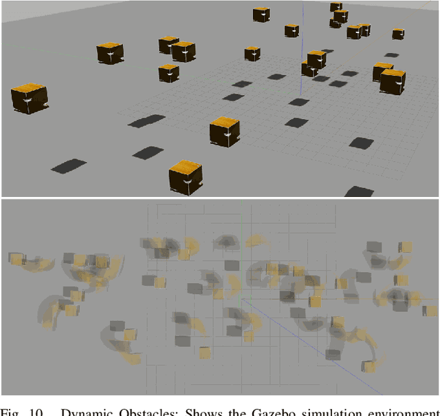
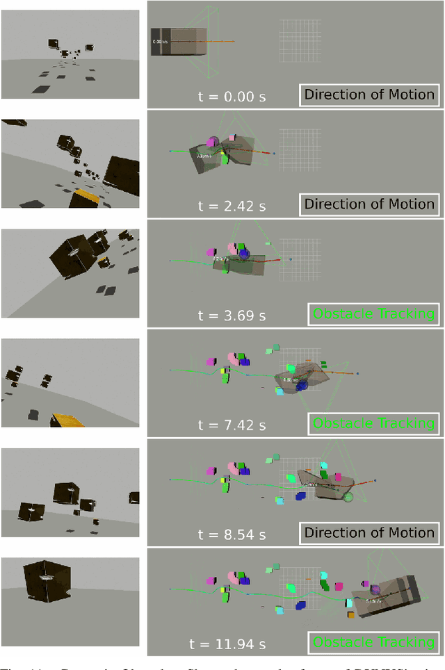
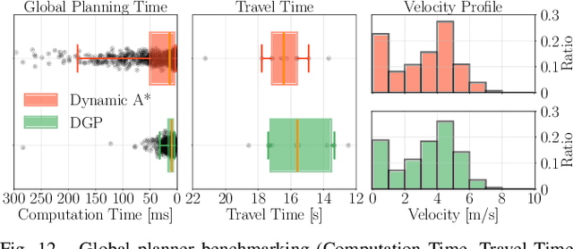
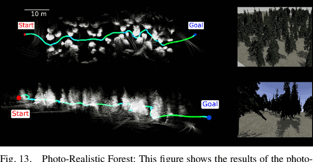
This paper introduces DYNUS, an uncertainty-aware trajectory planner designed for dynamic unknown environments. Operating in such settings presents many challenges -- most notably, because the agent cannot predict the ground-truth future paths of obstacles, a previously planned trajectory can become unsafe at any moment, requiring rapid replanning to avoid collisions. Recently developed planners have used soft-constraint approaches to achieve the necessary fast computation times; however, these methods do not guarantee collision-free paths even with static obstacles. In contrast, hard-constraint methods ensure collision-free safety, but typically have longer computation times. To address these issues, we propose three key contributions. First, the DYNUS Global Planner (DGP) and Temporal Safe Corridor Generation operate in spatio-temporal space and handle both static and dynamic obstacles in the 3D environment. Second, the Safe Planning Framework leverages a combination of exploratory, safe, and contingency trajectories to flexibly re-route when potential future collisions with dynamic obstacles are detected. Finally, the Fast Hard-Constraint Local Trajectory Formulation uses a variable elimination approach to reduce the problem size and enable faster computation by pre-computing dependencies between free and dependent variables while still ensuring collision-free trajectories. We evaluated DYNUS in a variety of simulations, including dense forests, confined office spaces, cave systems, and dynamic environments. Our experiments show that DYNUS achieves a success rate of 100% and travel times that are approximately 25.0% faster than state-of-the-art methods. We also evaluated DYNUS on multiple platforms -- a quadrotor, a wheeled robot, and a quadruped -- in both simulation and hardware experiments.
REAL: Resilience and Adaptation using Large Language Models on Autonomous Aerial Robots
Nov 02, 2023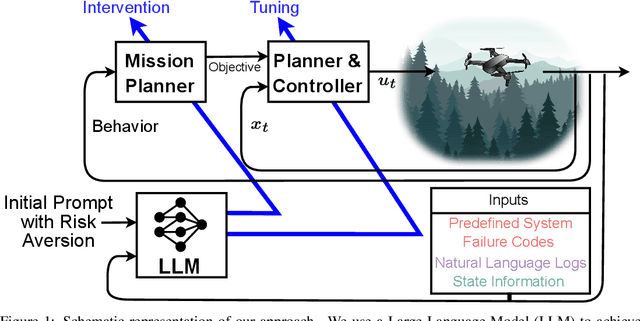
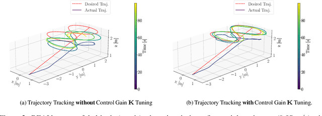
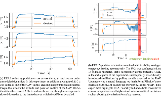
Large Language Models (LLMs) pre-trained on internet-scale datasets have shown impressive capabilities in code understanding, synthesis, and general purpose question-and-answering. Key to their performance is the substantial prior knowledge acquired during training and their ability to reason over extended sequences of symbols, often presented in natural language. In this work, we aim to harness the extensive long-term reasoning, natural language comprehension, and the available prior knowledge of LLMs for increased resilience and adaptation in autonomous mobile robots. We introduce REAL, an approach for REsilience and Adaptation using LLMs. REAL provides a strategy to employ LLMs as a part of the mission planning and control framework of an autonomous robot. The LLM employed by REAL provides (i) a source of prior knowledge to increase resilience for challenging scenarios that the system had not been explicitly designed for; (ii) a way to interpret natural-language and other log/diagnostic information available in the autonomy stack, for mission planning; (iii) a way to adapt the control inputs using minimal user-provided prior knowledge about the dynamics/kinematics of the robot. We integrate REAL in the autonomy stack of a real multirotor, querying onboard an offboard LLM at 0.1-1.0 Hz as part the robot's mission planning and control feedback loops. We demonstrate in real-world experiments the ability of the LLM to reduce the position tracking errors of a multirotor under the presence of (i) errors in the parameters of the controller and (ii) unmodeled dynamics. We also show (iii) decision making to avoid potentially dangerous scenarios (e.g., robot oscillates) that had not been explicitly accounted for in the initial prompt design.