 Add to Chrome
 Add to Firefox
 Add to Edge
A Joint Learning Framework with Feature Reconstruction and Prediction for Incomplete Satellite Image Time Series in Agricultural Semantic Segmentation
May 25, 2025


Satellite Image Time Series (SITS) is crucial for agricultural semantic segmentation. However, Cloud contamination introduces time gaps in SITS, disrupting temporal dependencies and causing feature shifts, leading to degraded performance of models trained on complete SITS. Existing methods typically address this by reconstructing the entire SITS before prediction or using data augmentation to simulate missing data. Yet, full reconstruction may introduce noise and redundancy, while the data-augmented model can only handle limited missing patterns, leading to poor generalization. We propose a joint learning framework with feature reconstruction and prediction to address incomplete SITS more effectively. During training, we simulate data-missing scenarios using temporal masks. The two tasks are guided by both ground-truth labels and the teacher model trained on complete SITS. The prediction task constrains the model from selectively reconstructing critical features from masked inputs that align with the teacher's temporal feature representations. It reduces unnecessary reconstruction and limits noise propagation. By integrating reconstructed features into the prediction task, the model avoids learning shortcuts and maintains its ability to handle varied missing patterns and complete SITS. Experiments on SITS from Hunan Province, Western France, and Catalonia show that our method improves mean F1-scores by 6.93% in cropland extraction and 7.09% in crop classification over baselines. It also generalizes well across satellite sensors, including Sentinel-2 and PlanetScope, under varying temporal missing rates and model backbones.
Enhancing Scene Classification in Cloudy Image Scenarios: A Collaborative Transfer Method with Information Regulation Mechanism using Optical Cloud-Covered and SAR Remote Sensing Images
Jan 08, 2025


In remote sensing scene classification, leveraging the transfer methods with well-trained optical models is an efficient way to overcome label scarcity. However, cloud contamination leads to optical information loss and significant impacts on feature distribution, challenging the reliability and stability of transferred target models. Common solutions include cloud removal for optical data or directly using Synthetic aperture radar (SAR) data in the target domain. However, cloud removal requires substantial auxiliary data for support and pre-training, while directly using SAR disregards the unobstructed portions of optical data. This study presents a scene classification transfer method that synergistically combines multi-modality data, which aims to transfer the source domain model trained on cloudfree optical data to the target domain that includes both cloudy optical and SAR data at low cost. Specifically, the framework incorporates two parts: (1) the collaborative transfer strategy, based on knowledge distillation, enables the efficient prior knowledge transfer across heterogeneous data; (2) the information regulation mechanism (IRM) is proposed to address the modality imbalance issue during transfer. It employs auxiliary models to measure the contribution discrepancy of each modality, and automatically balances the information utilization of modalities during the target model learning process at the sample-level. The transfer experiments were conducted on simulated and real cloud datasets, demonstrating the superior performance of the proposed method compared to other solutions in cloud-covered scenarios. We also verified the importance and limitations of IRM, and further discussed and visualized the modality imbalance problem during the model transfer. Codes are available at https://github.com/wangyuze-csu/ESCCS
3D Fully Convolutional Neural Networks with Intersection Over Union Loss for Crop Mapping from Multi-Temporal Satellite Images
Feb 15, 2021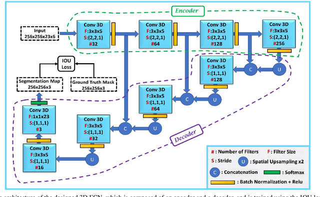
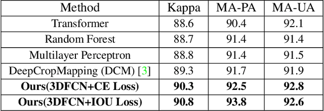
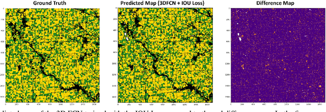
Information on cultivated crops is relevant for a large number of food security studies. Different scientific efforts are dedicated to generate this information from remote sensing images by means of machine learning methods. Unfortunately, these methods do not account for the spatial-temporal relationships inherent in remote sensing images. In our paper, we explore the capability of a 3D Fully Convolutional Neural Network (FCN) to map crop types from multi-temporal images. In addition, we propose the Intersection Over Union (IOU) loss function for increasing the overlap between the predicted classes and ground truth data. The proposed method was applied to identify soybean and corn from a study area situated in the US corn belt using multi-temporal Landsat images. The study shows that our method outperforms related methods, obtaining a Kappa coefficient of 90.8%. We conclude that using the IOU Loss function provides a superior choice to learn individual crop types.