 Add to Chrome
 Add to Firefox
 Add to Edge
Spatial-temporal water area monitoring of Miyun Reservoir using remote sensing imagery from 1984 to 2020
Oct 14, 2021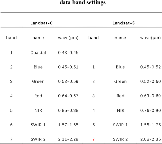
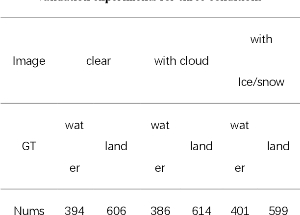
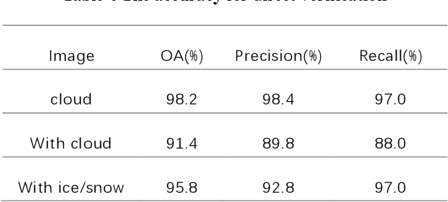
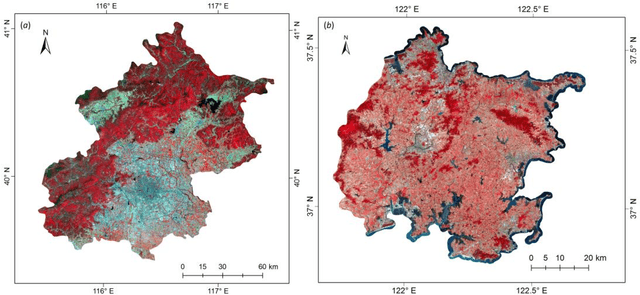
Miyun Reservoir has produced huge benefits in flood control, agricultural irrigation, power generation, aquaculture, tourism, and urban water supply. Accurately water mapping is of great significance to the ecological environment monitoring of the Miyun Reservoir and the management of the South-to-North Water Diversion Project. On the 60th anniversary of the completion of the Miyun Reservoir, we took the Miyun Reservoir as the study area and collected all the Landsat-5 and Landsat-8 remote sensing images from 1984 to 2020 for water mapping. Based on the spectral, topographical and temporal-spatial characteristics of water, we proposed an automated method for long-term researvoir mapping, which can solve the problems caused by cloud, shadow, ice and snow pixels. Moreover, it can also deal with 'the same objects with different spectra' and spectral mixed problems. The overall accuracy is as high as 98.2% for the case with no cloud or snow/ice cover. The landscape division index is introduced to analyze the morphological changes of Miyun Reservoir. Based on the mapping results, we analyzed the changes of Miyun Reservoir from 1984 to 2020 and the driving factors of them.
Probabilistic graphical model based approach for water mapping using GaoFen-2 (GF-2) high resolution imagery and Landsat 8 time series
Dec 22, 2016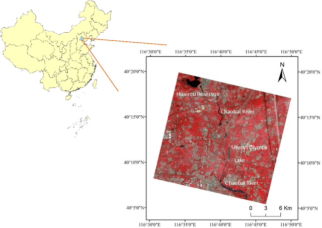
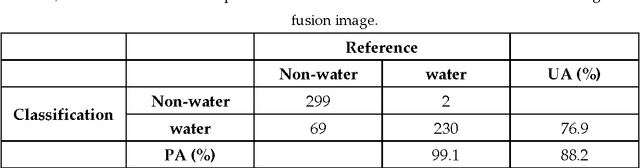
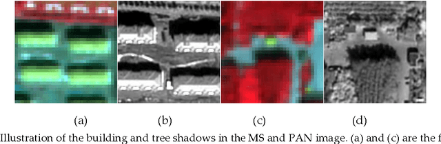
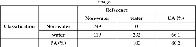
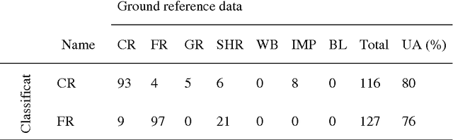
The objective of this paper is to evaluate the potential of Gaofen-2 (GF-2) high resolution multispectral sensor (MS) and panchromatic (PAN) imagery on water mapping. Difficulties of water mapping on high resolution data includes: 1) misclassification between water and shadows or other low-reflectance ground objects, which is mostly caused by the spectral similarity within the given band range; 2) small water bodies with size smaller than the spatial resolution of MS image. To solve the confusion between water and low-reflectance objects, the Landsat 8 time series with two shortwave infrared (SWIR) bands is added because water has extremely strong absorption in SWIR. In order to integrate the three multi-sensor, multi-resolution data sets, the probabilistic graphical model (PGM) is utilized here with conditional probability distribution defined mainly based on the size of each object. For comparison, results from the SVM classifier on the PCA fused and MS data, thresholding method on the PAN image, and water index method on the Landsat data are computed. The confusion matrices are calculated for all the methods. The results demonstrate that the PGM method can achieve the best performance with the highest overall accuracy. Moreover, small rivers can also be extracted by adding weight on the PAN result in PGM. Finally, the post-classification procedure is applied on the PGM result to further exclude misclassification in shadow and water-land boundary regions. Accordingly, the producer's, user's and overall accuracy are all increased, indicating the effectiveness of our method.
A probabilistic graphical model approach in 30 m land cover mapping with multiple data sources
Dec 11, 2016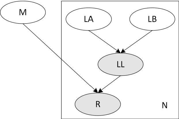
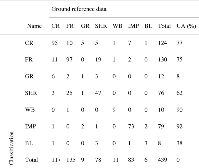
There is a trend to acquire high accuracy land-cover maps using multi-source classification methods, most of which are based on data fusion, especially pixel- or feature-level fusions. A probabilistic graphical model (PGM) approach is proposed in this research for 30 m resolution land-cover mapping with multi-temporal Landsat and MODerate Resolution Imaging Spectroradiometer (MODIS) data. Independent classifiers were applied to two single-date Landsat 8 scenes and the MODIS time-series data, respectively, for probability estimation. A PGM was created for each pixel in Landsat 8 data. Conditional probability distributions were computed based on data quality and reliability by using information selectively. Using the administrative territory of Beijing City (Area-1) and a coastal region of Shandong province, China (Area-2) as study areas, multiple land-cover maps were generated for comparison. Quantitative results show the effectiveness of the proposed method. Overall accuracies promoted from 74.0% (maps acquired from single-temporal Landsat images) to 81.8% (output of the PGM) for Area-1. Improvements can also be seen when using MODIS data and only a single-temporal Landsat image as input (overall accuracy: 78.4% versus 74.0% for Area-1, and 86.8% versus 83.0% for Area-2). Information from MODIS data did not help much when the PGM was applied to cloud free regions of. One of the advantages of the proposed method is that it can be applied where multi-temporal data cannot be simply stacked as a multi-layered image.
An automatic bad band preremoval algorithm for hyperspectral imagery
Oct 19, 2016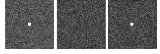
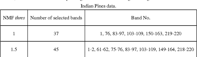
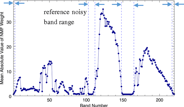
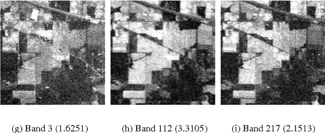
For most hyperspectral remote sensing applications, removing bad bands, such as water absorption bands, is a required preprocessing step. Currently, the commonly applied method is by visual inspection, which is very time-consuming and it is easy to overlook some noisy bands. In this study, we find an inherent connection between target detection algorithms and the corrupted band removal. As an example, for the matched filter (MF), which is the most widely used target detection method for hyperspectral data, we present an automatic MF-based algorithm for bad band identification. The MF detector is a filter vector, and the resulting filter output is the sum of all bands weighted by the MF coefficients. Therefore, we can identify bad bands only by using the MF filter vector itself, the absolute value of whose entry accounts for the importance of each band for the target detection. For a specific target of interest, the bands with small MF weights correspond to the noisy or bad ones. Based on this fact, we develop an automatic bad band preremoval algorithm by utilizing the average absolute value of MF weights for multiple targets within a scene. Experiments with three well known hyperspectral datasets show that our method can always identify the water absorption and other low signal-to-noise (SNR) bands that are usually chosen as bad bands manually.