 Add to Chrome
 Add to Firefox
 Add to Edge
Plume Segmentation from MethaneSAT with Cross-Sensor Transfer Learning and Physics-Informed Postprocessing
May 22, 2026Automated detection and masking of individual methane plumes from satellite imagery is important for operational emission attribution and quantification. We present a machine learning framework for plume detection from MethaneSAT retrieved column-averaged dry-air mole fractions of methane. We address two core challenges: the scarcity of labeled MethaneSAT data and the need for inference reliability across diverse atmospheric and surface conditions. We first demonstrate that Mask R-CNN with a ResNet-50 backbone outperforms U-Net semantic segmentation on both MethaneAIR (an airborne version of MethaneSAT) and MethaneSAT data, with pixel-level F1 score gains of 10.49 and 5.48 respectively. To address MethaneSAT data scarcity, we evaluate three cross-sensor transfer strategies leveraging MethaneAIR flights and synthetic plumes. Mask R-CNN with ResNet-50 fine-tuned from MethaneAIR pre-trained weights is the most effective strategy, achieving instance-level precision of 0.60 and a near-perfect recall of 0.98 at the baseline operating point. A physics-informed post-processing pipeline converts detections into two operationally distinct modes. The first is a high-sensitivity mode that applies morphological filtering and proximity-based merging for comprehensive emission screening, achieving precision of 0.71 and recall of 0.94. The second is a high-precision mode that additionally applies a distribution-based classifier for confident source attribution, achieving precision of 0.92 and recall of 0.70. Manual review of detections classified as false positives against our wavelet-based ground truth labels reveals that a meaningful fraction of cases correspond to real methane enhancements excluded by conservative labeling criteria, indicating that precision values reported are lower bounds on true detection performance... Our data and code are available at: https://doi.org/10.7910/DVN/FR959H
Fully Automatic Trace Gas Plume Detection
May 05, 2026Future imaging spectrometers will increase data volumes by orders of magnitude, requiring automated detection of trace gas point sources. We present a fully automated framework that combines machine learning-based morphological analysis with physics-based spectroscopic fitting to detect plumes without human participation. Applied to EMIT imaging spectrometer data, the system operates in two modes: "daily digest" that runs automatically on all downlinked data, flagging the largest events for immediate response, and a retrospective analysis that identifies plumes missed by prior human review. The daily digest demonstrates that a significant fraction of the largest plumes can be detected automatically with negligible false positives, while retrospective analysis suggests at least 25% of plumes may have been overlooked. In addition to the previously observed methane point sources, we extend detection to three understudied trace gases: NH3, NO2 and the first observations of carbon monoxide (CO) plume in EMIT imagery.
Operational machine learning for remote spectroscopic detection of CH$_{4}$ point sources
Nov 11, 2025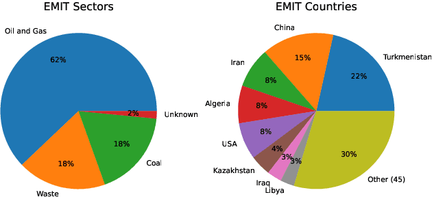
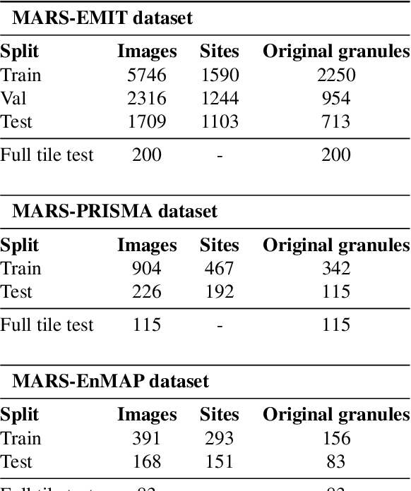
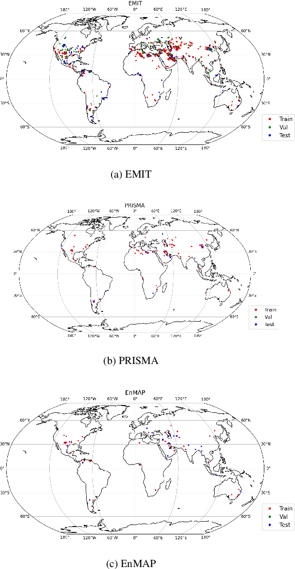
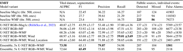
Mitigating anthropogenic methane sources is one the most cost-effective levers to slow down global warming. While satellite-based imaging spectrometers, such as EMIT, PRISMA, and EnMAP, can detect these point sources, current methane retrieval methods based on matched filters still produce a high number of false detections requiring laborious manual verification. This paper describes the operational deployment of a machine learning system for detecting methane emissions within the Methane Alert and Response System (MARS) of the United Nations Environment Programme's International Methane Emissions Observatory. We created the largest and most diverse global dataset of annotated methane plumes from three imaging spectrometer missions and quantitatively compared different deep learning model configurations. Focusing on the requirements for operational deployment, we extended prior evaluation methodologies from small tiled datasets to full granule evaluation. This revealed that deep learning models still produce a large number of false detections, a problem we address with model ensembling, which reduced false detections by over 74%. Deployed in the MARS pipeline, our system processes scenes and proposes plumes to analysts, accelerating the detection and analysis process. During seven months of operational deployment, it facilitated the verification of 1,351 distinct methane leaks, resulting in 479 stakeholder notifications. We further demonstrate the model's utility in verifying mitigation success through case studies in Libya, Argentina, Oman, and Azerbaijan. Our work represents a critical step towards a global AI-assisted methane leak detection system, which is required to process the dramatically higher data volumes expected from new and current imaging spectrometers.
Estimating Crop Primary Productivity with Sentinel-2 and Landsat 8 using Machine Learning Methods Trained with Radiative Transfer Simulations
Dec 07, 2020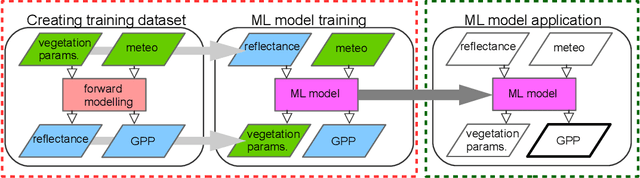
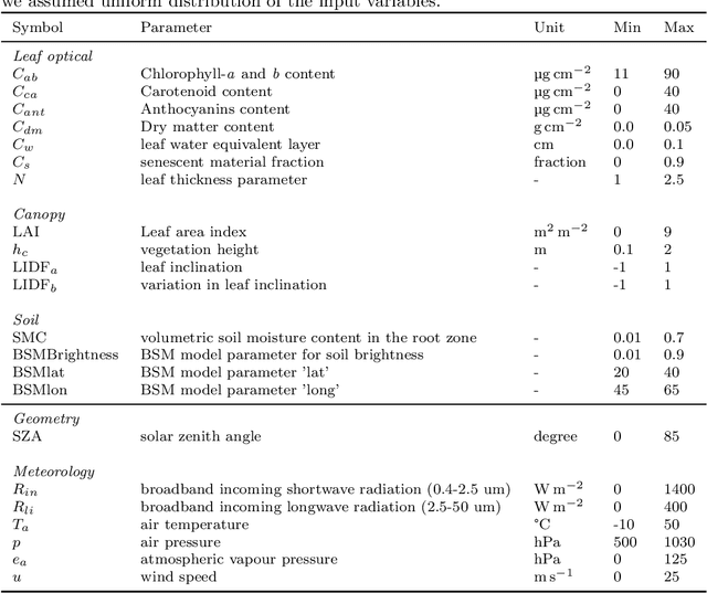
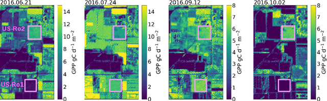
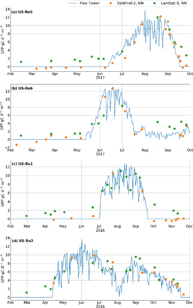
Satellite remote sensing has been widely used in the last decades for agricultural applications, {both for assessing vegetation condition and for subsequent yield prediction.} Existing remote sensing-based methods to estimate gross primary productivity (GPP), which is an important variable to indicate crop photosynthetic function and stress, typically rely on empirical or semi-empirical approaches, which tend to over-simplify photosynthetic mechanisms. In this work, we take advantage of all parallel developments in mechanistic photosynthesis modeling and satellite data availability for advanced monitoring of crop productivity. In particular, we combine process-based modeling with the soil-canopy energy balance radiative transfer model (SCOPE) with Sentinel-2 {and Landsat 8} optical remote sensing data and machine learning methods in order to estimate crop GPP. Our model successfully estimates GPP across a variety of C3 crop types and environmental conditions even though it does not use any local information from the corresponding sites. This highlights its potential to map crop productivity from new satellite sensors at a global scale with the help of current Earth observation cloud computing platforms.