 Add to Chrome
 Add to Firefox
 Add to Edge
Image Denoising Using Transformed L1 (TL1) Regularization via ADMM
Nov 19, 2025


Total variation (TV) regularization is a classical tool for image denoising, but its convex $\ell_1$ formulation often leads to staircase artifacts and loss of contrast. To address these issues, we introduce the Transformed $\ell_1$ (TL1) regularizer applied to image gradients. In particular, we develop a TL1-regularized denoising model and solve it using the Alternating Direction Method of Multipliers (ADMM), featuring a closed-form TL1 proximal operator and an FFT-based image update under periodic boundary conditions. Experimental results demonstrate that our approach achieves superior denoising performance, effectively suppressing noise while preserving edges and enhancing image contrast.
Signal and Image Recovery with Scale and Signed Permutation Invariant Sparsity-Promoting Functions
Nov 08, 2025Sparse signal recovery has been a cornerstone of advancements in data processing and imaging. Recently, the squared ratio of $\ell_1$ to $\ell_2$ norms, $(\ell_1/\ell_2)^2$, has been introduced as a sparsity-prompting function, showing superior performance compared to traditional $\ell_1$ minimization, particularly in challenging scenarios with high coherence and dynamic range. This paper explores the integration of the proximity operator of $(\ell_1/\ell_2)^2$ and $\ell_1/\ell_2$ into efficient optimization frameworks, including the Accelerated Proximal Gradient (APG) and Alternating Direction Method of Multipliers (ADMM). We rigorously analyze the convergence properties of these algorithms and demonstrate their effectiveness in compressed sensing and image restoration applications. Numerical experiments highlight the advantages of our proposed methods in terms of recovery accuracy and computational efficiency, particularly under noise and high-coherence conditions.
Semantic-Aware Label Placement for Augmented Reality in Street View
Dec 15, 2019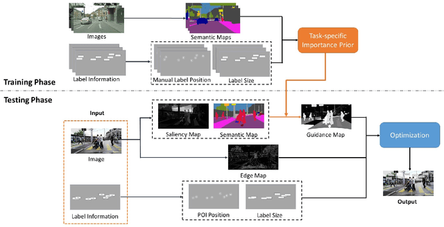
In an augmented reality (AR) application, placing labels in a manner that is clear and readable without occluding the critical information from the real-world can be a challenging problem. This paper introduces a label placement technique for AR used in street view scenarios. We propose a semantic-aware task-specific label placement method by identifying potentially important image regions through a novel feature map, which we refer to as guidance map. Given an input image, its saliency information, semantic information and the task-specific importance prior are integrated into the guidance map for our labeling task. To learn the task prior, we created a label placement dataset with the users' labeling preferences, as well as use it for evaluation. Our solution encodes the constraints for placing labels in an optimization problem to obtain the final label layout, and the labels will be placed in appropriate positions to reduce the chances of overlaying important real-world objects in street view AR scenarios. The experimental validation shows clearly the benefits of our method over previous solutions in the AR street view navigation and similar applications.