 Add to Chrome
 Add to Firefox
 Add to Edge
WildBox: A Dataset and Benchmark for Aerial Monocular 3D Detection of African Savanna Wildlife
Jun 19, 2026
We introduce WildBox, a dataset and benchmark for monocular 3D detection of wildlife from drone video, comprising 237,505 3D bounding box annotations across seven African savanna species grouped into six benchmark classes. Annotations follow a KITTI/Omni3D-compatible format in a per-segment scale-normalised camera frame, with instance identities maintained across each segment. We evaluate two open-vocabulary monocular 3D architectures, OVMono3D-LIFT and DetAny3D, under zero-shot, ground-truth 2D box prompt, and supervised fine-tuning protocols. Open-vocabulary 2D foundation models provide usable zero-shot wildlife localisation (50.55 AP@50), but zero-shot 3D detection collapses to 0.00 AP across both architectures and every 2D-input condition tested, including ground-truth 2D box prompts, thus isolating the failure to the 3D stage. Fine-tuning on WildBox recovers performance to 8.68 +/- 0.47 AP-BEV@0.50 and 13.17 +/- 0.69 AP3D macro. Depth contributes 84% of normalised Hausdorff distance after fine-tuning and over 99% in zero-shot, identifying monocular aerial depth as the dominant open problem in this regime. A coarse-to-fine curriculum, i.e. pretraining on a merged zebra class before fine-tuning on the Grevy's/plains split, improves macro 3D performance with less total compute, with the largest gains on the two zebra subclasses. WildBox is released with video-level splits, evaluation code, and baseline checkpoints to enable progress in 3D wildlife perception from drone video.

Integrating Biological Data into Autonomous Remote Sensing Systems for In Situ Imageomics: A Case Study for Kenyan Animal Behavior Sensing with Unmanned Aerial Vehicles (UAVs)
Jul 23, 2024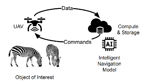

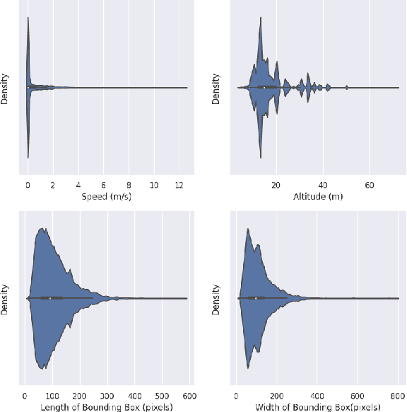
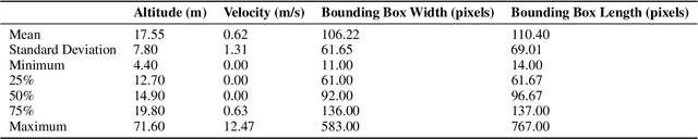
In situ imageomics leverages machine learning techniques to infer biological traits from images collected in the field, or in situ, to study individuals organisms, groups of wildlife, and whole ecosystems. Such datasets provide real-time social and environmental context to inferred biological traits, which can enable new, data-driven conservation and ecosystem management. The development of machine learning techniques to extract biological traits from images are impeded by the volume and quality data required to train these models. Autonomous, unmanned aerial vehicles (UAVs), are well suited to collect in situ imageomics data as they can traverse remote terrain quickly to collect large volumes of data with greater consistency and reliability compared to manually piloted UAV missions. However, little guidance exists on optimizing autonomous UAV missions for the purposes of remote sensing for conservation and biodiversity monitoring. The UAV video dataset curated by KABR: In-Situ Dataset for Kenyan Animal Behavior Recognition from Drone Videos required three weeks to collect, a time-consuming and expensive endeavor. Our analysis of KABR revealed that a third of the videos gathered were unusable for the purposes of inferring wildlife behavior. We analyzed the flight telemetry data from portions of UAV videos that were usable for inferring wildlife behavior, and demonstrate how these insights can be integrated into an autonomous remote sensing system to track wildlife in real time. Our autonomous remote sensing system optimizes the UAV's actions to increase the yield of usable data, and matches the flight path of an expert pilot with an 87% accuracy rate, representing an 18.2% improvement in accuracy over previously proposed methods.