 Add to Chrome
 Add to Firefox
 Add to Edge
Hybrid Machine Learning Model for Forest Height Estimation from TanDEM-X and Landsat Data
May 20, 2026Integrating machine learning (ML) with physical models (PM) has emerged as a promising way of retrieving geophysical parameters from remote sensing data. In this context, a ML model for estimating forest height from TanDEM-X interferometric coherence measurements has recently been proposed, that constrains the learning process through a PM. While the features used for training and inversion where selected to ensure the physical consistency of the solutions, they could not resolve all height / structure and baseline / terrain slope ambiguities in the data. To improve this, the extension of the feature space with optical Landsat data is proposed able to provide complementary information on forest type or structure. The extended model is applied and validated on several TanDEM-X acquisitions over the Gabonese Lopé national park site and assessed against airborne LiDAR measurements. Results show a 13.5% reduction in RMSE and a 16.6% reduction in MAE compared to the original hybrid model, confirming the added value of multispectral inputs.
Hybrid AI-Physical Modeling for Penetration Bias Correction in X-band InSAR DEMs: A Greenland Case Study
Apr 11, 2025Digital elevation models derived from Interferometric Synthetic Aperture Radar (InSAR) data over glacial and snow-covered regions often exhibit systematic elevation errors, commonly termed "penetration bias." We leverage existing physics-based models and propose an integrated correction framework that combines parametric physical modeling with machine learning. We evaluate the approach across three distinct training scenarios - each defined by a different set of acquisition parameters - to assess overall performance and the model's ability to generalize. Our experiments on Greenland's ice sheet using TanDEM-X data show that the proposed hybrid model corrections significantly reduce the mean and standard deviation of DEM errors compared to a purely physical modeling baseline. The hybrid framework also achieves significantly improved generalization than a pure ML approach when trained on data with limited diversity in acquisition parameters.
Self-Supervised Pretraining and Controlled Augmentation Improve Rare Wildlife Recognition in UAV Images
Aug 17, 2021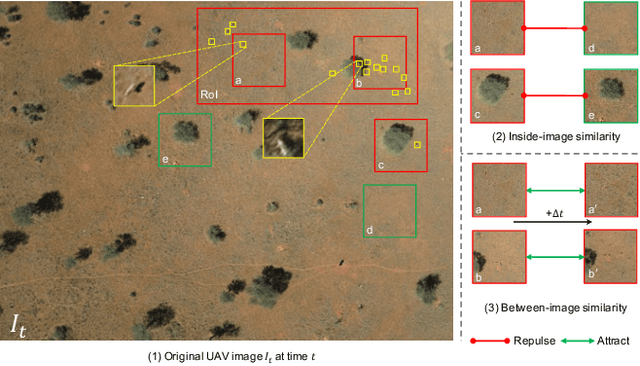
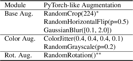

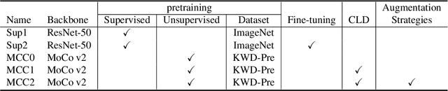
Automated animal censuses with aerial imagery are a vital ingredient towards wildlife conservation. Recent models are generally based on deep learning and thus require vast amounts of training data. Due to their scarcity and minuscule size, annotating animals in aerial imagery is a highly tedious process. In this project, we present a methodology to reduce the amount of required training data by resorting to self-supervised pretraining. In detail, we examine a combination of recent contrastive learning methodologies like Momentum Contrast (MoCo) and Cross-Level Instance-Group Discrimination (CLD) to condition our model on the aerial images without the requirement for labels. We show that a combination of MoCo, CLD, and geometric augmentations outperforms conventional models pre-trained on ImageNet by a large margin. Crucially, our method still yields favorable results even if we reduce the number of training animals to just 10%, at which point our best model scores double the recall of the baseline at similar precision. This effectively allows reducing the number of required annotations to a fraction while still being able to train high-accuracy models in such highly challenging settings.