 Add to Chrome
 Add to Firefox
 Add to Edge
Hybrid Machine Learning Model for Forest Height Estimation from TanDEM-X and Landsat Data
May 20, 2026Integrating machine learning (ML) with physical models (PM) has emerged as a promising way of retrieving geophysical parameters from remote sensing data. In this context, a ML model for estimating forest height from TanDEM-X interferometric coherence measurements has recently been proposed, that constrains the learning process through a PM. While the features used for training and inversion where selected to ensure the physical consistency of the solutions, they could not resolve all height / structure and baseline / terrain slope ambiguities in the data. To improve this, the extension of the feature space with optical Landsat data is proposed able to provide complementary information on forest type or structure. The extended model is applied and validated on several TanDEM-X acquisitions over the Gabonese Lopé national park site and assessed against airborne LiDAR measurements. Results show a 13.5% reduction in RMSE and a 16.6% reduction in MAE compared to the original hybrid model, confirming the added value of multispectral inputs.
Hybrid AI-Physical Modeling for Penetration Bias Correction in X-band InSAR DEMs: A Greenland Case Study
Apr 11, 2025Digital elevation models derived from Interferometric Synthetic Aperture Radar (InSAR) data over glacial and snow-covered regions often exhibit systematic elevation errors, commonly termed "penetration bias." We leverage existing physics-based models and propose an integrated correction framework that combines parametric physical modeling with machine learning. We evaluate the approach across three distinct training scenarios - each defined by a different set of acquisition parameters - to assess overall performance and the model's ability to generalize. Our experiments on Greenland's ice sheet using TanDEM-X data show that the proposed hybrid model corrections significantly reduce the mean and standard deviation of DEM errors compared to a purely physical modeling baseline. The hybrid framework also achieves significantly improved generalization than a pure ML approach when trained on data with limited diversity in acquisition parameters.
SpaceNet 6: Multi-Sensor All Weather Mapping Dataset
Apr 14, 2020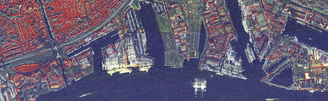
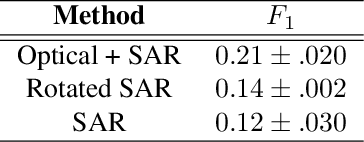
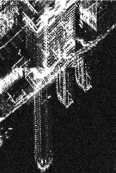
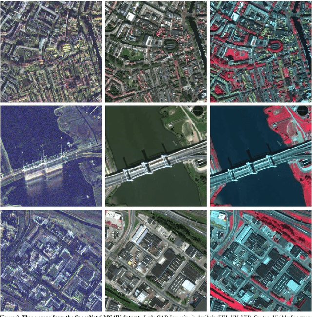
Within the remote sensing domain, a diverse set of acquisition modalities exist, each with their own unique strengths and weaknesses. Yet, most of the current literature and open datasets only deal with electro-optical (optical) data for different detection and segmentation tasks at high spatial resolutions. optical data is often the preferred choice for geospatial applications, but requires clear skies and little cloud cover to work well. Conversely, Synthetic Aperture Radar (SAR) sensors have the unique capability to penetrate clouds and collect during all weather, day and night conditions. Consequently, SAR data are particularly valuable in the quest to aid disaster response, when weather and cloud cover can obstruct traditional optical sensors. Despite all of these advantages, there is little open data available to researchers to explore the effectiveness of SAR for such applications, particularly at very-high spatial resolutions, i.e. <1m Ground Sample Distance (GSD). To address this problem, we present an open Multi-Sensor All Weather Mapping (MSAW) dataset and challenge, which features two collection modalities (both SAR and optical). The dataset and challenge focus on mapping and building footprint extraction using a combination of these data sources. MSAW covers 120 km^2 over multiple overlapping collects and is annotated with over 48,000 unique building footprints labels, enabling the creation and evaluation of mapping algorithms for multi-modal data. We present a baseline and benchmark for building footprint extraction with SAR data and find that state-of-the-art segmentation models pre-trained on optical data, and then trained on SAR (F1 score of 0.21) outperform those trained on SAR data alone (F1 score of 0.135).