 Add to Chrome
 Add to Firefox
 Add to Edge
Composite Safety Potential Field for Highway Driving Risk Assessment
Apr 29, 2025In the era of rapid advancements in vehicle safety technologies, driving risk assessment has become a focal point of attention. Technologies such as collision warning systems, advanced driver assistance systems (ADAS), and autonomous driving require driving risks to be evaluated proactively and in real time. To be effective, driving risk assessment metrics must not only accurately identify potential collisions but also exhibit human-like reasoning to enable safe and seamless interactions between vehicles. Existing safety potential field models assess driving risks by considering both objective and subjective safety factors. However, their practical applicability in real-world risk assessment tasks is limited. These models are often challenging to calibrate due to the arbitrary nature of their structures, and calibration can be inefficient because of the scarcity of accident statistics. Additionally, they struggle to generalize across both longitudinal and lateral risks. To address these challenges, we propose a composite safety potential field framework, namely C-SPF, involving a subjective field to capture drivers' risk perception about spatial proximity and an objective field to quantify the imminent collision probability, to comprehensively evaluate driving risks. The C-SPF is calibrated using abundant two-dimensional spacing data from trajectory datasets, enabling it to effectively capture drivers' proximity risk perception and provide a more realistic explanation of driving behaviors. Analysis of a naturalistic driving dataset demonstrates that the C-SPF can capture both longitudinal and lateral risks that trigger drivers' safety maneuvers. Further case studies highlight the C-SPF's ability to explain lateral driver behaviors, such as abandoning lane changes or adjusting lateral position relative to adjacent vehicles, which are capabilities that existing models fail to achieve.
Traffic Adaptive Moving-window Service Patrolling for Real-time Incident Management during High-impact Events
Apr 15, 2025


This paper presents the Traffic Adaptive Moving-window Patrolling Algorithm (TAMPA), designed to improve real-time incident management during major events like sports tournaments and concerts. Such events significantly stress transportation networks, requiring efficient and adaptive patrol solutions. TAMPA integrates predictive traffic modeling and real-time complaint estimation, dynamically optimizing patrol deployment. Using dynamic programming, the algorithm continuously adjusts patrol strategies within short planning windows, effectively balancing immediate response and efficient routing. Leveraging the Dvoretzky-Kiefer-Wolfowitz inequality, TAMPA detects significant shifts in complaint patterns, triggering proactive adjustments in patrol routes. Theoretical analyses ensure performance remains closely aligned with optimal solutions. Simulation results from an urban traffic network demonstrate TAMPA's superior performance, showing improvements of approximately 87.5\% over stationary methods and 114.2\% over random strategies. Future work includes enhancing adaptability and incorporating digital twin technology for improved predictive accuracy, particularly relevant for events like the 2026 FIFA World Cup at MetLife Stadium.
Multi-level Traffic-Responsive Tilt Camera Surveillance through Predictive Correlated Online Learning
Aug 05, 2024In urban traffic management, the primary challenge of dynamically and efficiently monitoring traffic conditions is compounded by the insufficient utilization of thousands of surveillance cameras along the intelligent transportation system. This paper introduces the multi-level Traffic-responsive Tilt Camera surveillance system (TTC-X), a novel framework designed for dynamic and efficient monitoring and management of traffic in urban networks. By leveraging widely deployed pan-tilt-cameras (PTCs), TTC-X overcomes the limitations of a fixed field of view in traditional surveillance systems by providing mobilized and 360-degree coverage. The innovation of TTC-X lies in the integration of advanced machine learning modules, including a detector-predictor-controller structure, with a novel Predictive Correlated Online Learning (PiCOL) methodology and the Spatial-Temporal Graph Predictor (STGP) for real-time traffic estimation and PTC control. The TTC-X is tested and evaluated under three experimental scenarios (e.g., maximum traffic flow capture, dynamic route planning, traffic state estimation) based on a simulation environment calibrated using real-world traffic data in Brooklyn, New York. The experimental results showed that TTC-X captured over 60\% total number of vehicles at the network level, dynamically adjusted its route recommendation in reaction to unexpected full-lane closure events, and reconstructed link-level traffic states with best MAE less than 1.25 vehicle/hour. Demonstrating scalability, cost-efficiency, and adaptability, TTC-X emerges as a powerful solution for urban traffic management in both cyber-physical and real-world environments.
Informed along the road: roadway capacity driven graph convolution network for network-wide traffic prediction
Jun 18, 2024


While deep learning has shown success in predicting traffic states, most methods treat it as a general prediction task without considering transportation aspects. Recently, graph neural networks have proven effective for this task, but few incorporate external factors that impact roadway capacity and traffic flow. This study introduces the Roadway Capacity Driven Graph Convolution Network (RCDGCN) model, which incorporates static and dynamic roadway capacity attributes in spatio-temporal settings to predict network-wide traffic states. The model was evaluated on two real-world datasets with different transportation factors: the ICM-495 highway network and an urban network in Manhattan, New York City. Results show RCDGCN outperformed baseline methods in forecasting accuracy. Analyses, including ablation experiments, weight analysis, and case studies, investigated the effect of capacity-related factors. The study demonstrates the potential of using RCDGCN for transportation system management.
Agent-based Simulation Model and Deep Learning Techniques to Evaluate and Predict Transportation Trends around COVID-19
Sep 23, 2020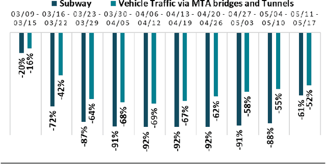
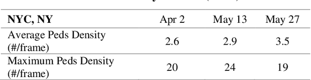
The COVID-19 pandemic has affected travel behaviors and transportation system operations, and cities are grappling with what policies can be effective for a phased reopening shaped by social distancing. This edition of the white paper updates travel trends and highlights an agent-based simulation model's results to predict the impact of proposed phased reopening strategies. It also introduces a real-time video processing method to measure social distancing through cameras on city streets.
An Interactive Data Visualization and Analytics Tool to Evaluate Mobility and Sociability Trends During COVID-19
Jun 26, 2020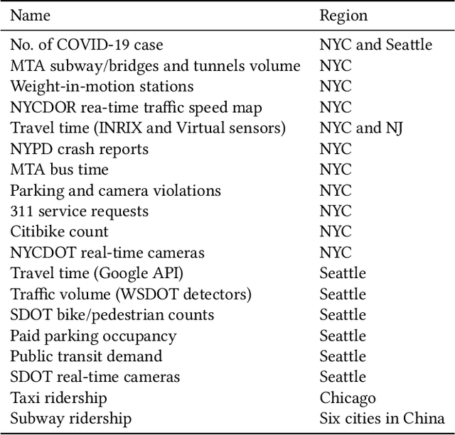
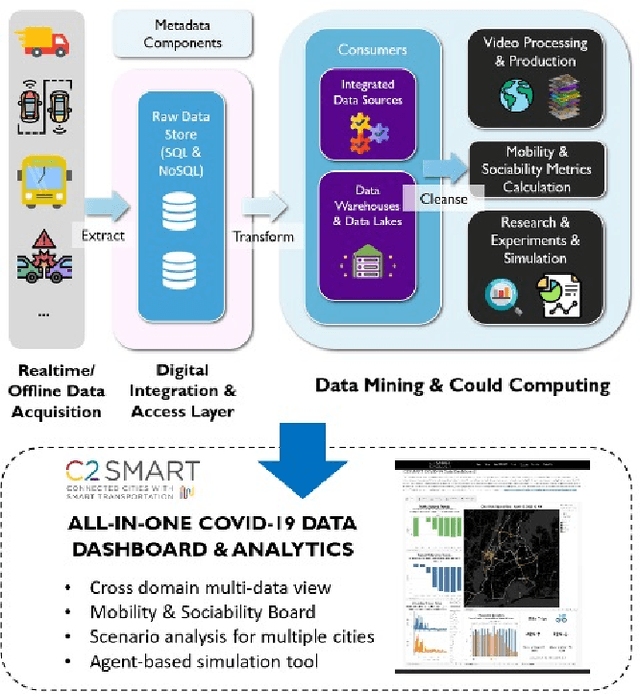
The COVID-19 outbreak has dramatically changed travel behavior in affected cities. The C2SMART research team has been investigating the impact of COVID-19 on mobility and sociability. New York City (NYC) and Seattle, two of the cities most affected by COVID-19 in the U.S. were included in our initial study. An all-in-one dashboard with data mining and cloud computing capabilities was developed for interactive data analytics and visualization to facilitate the understanding of the impact of the outbreak and corresponding policies such as social distancing on transportation systems. This platform is updated regularly and continues to evolve with the addition of new data, impact metrics, and visualizations to assist public and decision-makers to make informed decisions. This paper presents the architecture of the COVID related mobility data dashboard and preliminary mobility and sociability metrics for NYC and Seattle.