 Add to Chrome
 Add to Firefox
 Add to Edge
GRASP: Granularity-Aware Region Alignment and Semantic Prototype Learning for Fine-Grained Cross-Modal Understanding in Drone Views
Aug 10, 2026
Fine-grained cross-modal understanding in drone views is essential for aerial vision-language navigation. However, the inherent wide field of view and overhead perspective of drone scenarios impose dual challenges on vision-language understanding. At the macro level, overwhelming background clutter in visual representations leads to Cross-Modal Focus Misalignment, where the model prioritizes global environmental similarities over specific object details. At the micro level, Visual Isomorphism creates ambiguity, where candidates share similar geometric structures yet differ only in subtle attributes. To address these challenges, we propose the Granularity-Aware Region Alignment and Semantic Prototype (GRASP) learning framework, enhancing discriminative capability through two synergistic strategies. Specifically, we introduce Region-Focused Alignment (RFA) to promote object-centric cross-modal alignment while suppressing background interference. Concurrently, to tackle visual isomorphism, we propose Semantic Perturbation Enhanced Matching (SPEM), which leverages a foreground-purified Semantic Prototype Codebook (SPC) to construct semantically perturbed negatives for fine-grained semantic discrimination. Extensive experiments on the GeoText-1652 benchmark and the unseen ERA dataset demonstrate that GRASP achieves competitive performance in drone-view fine-grained image-text retrieval, validating its effectiveness for cross-modal understanding in aerial scenarios. Our code implementation is available at https://github.com/UCAS-JC/GRASP.

MotionScape: A Large-Scale Real-World Highly Dynamic UAV Video Dataset for World Models
Apr 09, 2026Recent advances in world models have demonstrated strong capabilities in simulating physical reality, making them an increasingly important foundation for embodied intelligence. For UAV agents in particular, accurate prediction of complex 3D dynamics is essential for autonomous navigation and robust decision-making in unconstrained environments. However, under the highly dynamic camera trajectories typical of UAV views, existing world models often struggle to maintain spatiotemporal physical consistency. A key reason lies in the distribution bias of current training data: most existing datasets exhibit restricted 2.5D motion patterns, such as ground-constrained autonomous driving scenes or relatively smooth human-centric egocentric videos, and therefore lack realistic high-dynamic 6-DoF UAV motion priors. To address this gap, we present MotionScape, a large-scale real-world UAV-view video dataset with highly dynamic motion for world modeling. MotionScape contains over 30 hours of 4K UAV-view videos, totaling more than 4.5M frames. This novel dataset features semantically and geometrically aligned training samples, where diverse real-world UAV videos are tightly coupled with accurate 6-DoF camera trajectories and fine-grained natural language descriptions. To build the dataset, we develop an automated multi-stage processing pipeline that integrates CLIP-based relevance filtering, temporal segmentation, robust visual SLAM for trajectory recovery, and large-language-model-driven semantic annotation. Extensive experiments show that incorporating such semantically and geometrically aligned annotations effectively improves the ability of existing world models to simulate complex 3D dynamics and handle large viewpoint shifts, thereby benefiting decision-making and planning for UAV agents in complex environments. The dataset is publicly available at https://github.com/Thelegendzz/MotionScape
RAPTOR: Real-Time High-Resolution UAV Video Prediction with Efficient Video Attention
Dec 25, 2025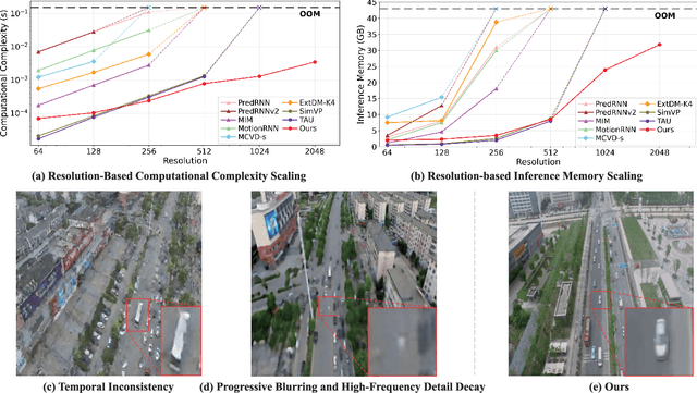
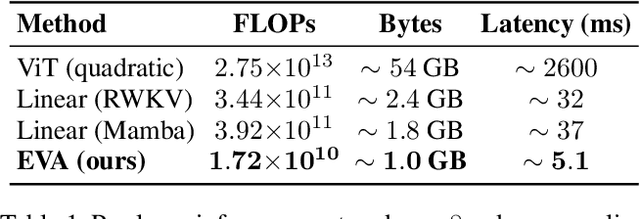
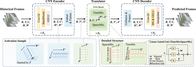
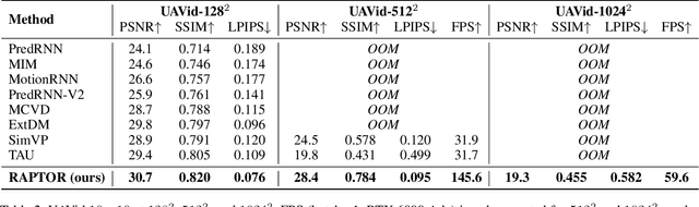
Video prediction is plagued by a fundamental trilemma: achieving high-resolution and perceptual quality typically comes at the cost of real-time speed, hindering its use in latency-critical applications. This challenge is most acute for autonomous UAVs in dense urban environments, where foreseeing events from high-resolution imagery is non-negotiable for safety. Existing methods, reliant on iterative generation (diffusion, autoregressive models) or quadratic-complexity attention, fail to meet these stringent demands on edge hardware. To break this long-standing trade-off, we introduce RAPTOR, a video prediction architecture that achieves real-time, high-resolution performance. RAPTOR's single-pass design avoids the error accumulation and latency of iterative approaches. Its core innovation is Efficient Video Attention (EVA), a novel translator module that factorizes spatiotemporal modeling. Instead of processing flattened spacetime tokens with $O((ST)^2)$ or $O(ST)$ complexity, EVA alternates operations along the spatial (S) and temporal (T) axes. This factorization reduces the time complexity to $O(S + T)$ and memory complexity to $O(max(S, T))$, enabling global context modeling at $512^2$ resolution and beyond, operating directly on dense feature maps with a patch-free design. Complementing this architecture is a 3-stage training curriculum that progressively refines predictions from coarse structure to sharp, temporally coherent details. Experiments show RAPTOR is the first predictor to exceed 30 FPS on a Jetson AGX Orin for $512^2$ video, setting a new state-of-the-art on UAVid, KTH, and a custom high-resolution dataset in PSNR, SSIM, and LPIPS. Critically, RAPTOR boosts the mission success rate in a real-world UAV navigation task by 18/%, paving the way for safer and more anticipatory embodied agents.
UNetMamba: An Efficient UNet-Like Mamba for Semantic Segmentation of High-Resolution Remote Sensing Images
Aug 26, 2024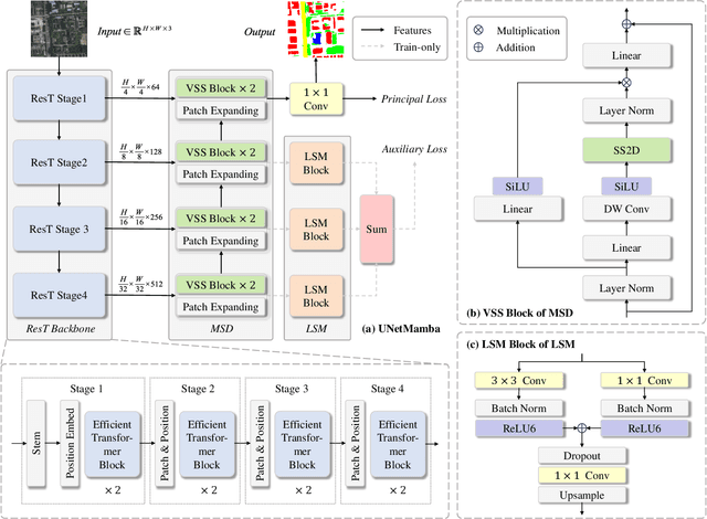
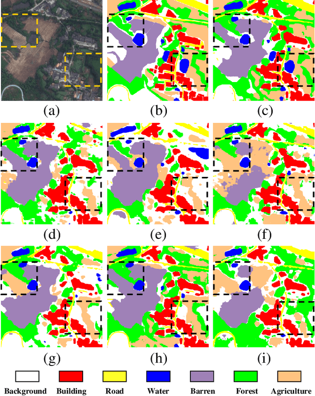
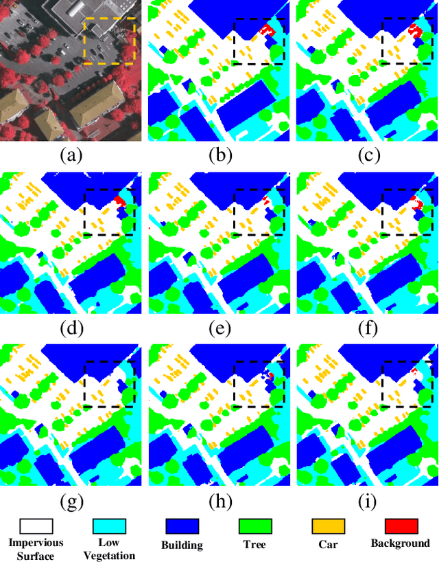

Semantic segmentation of high-resolution remote sensing images is vital in downstream applications such as land-cover mapping, urban planning and disaster assessment.Existing Transformer-based methods suffer from the constraint between accuracy and efficiency, while the recently proposed Mamba is renowned for being efficient. Therefore, to overcome the dilemma, we propose UNetMamba, a UNet-like semantic segmentation model based on Mamba. It incorporates a mamba segmentation decoder (MSD) that can efficiently decode the complex information within high-resolution images, and a local supervision module (LSM), which is train-only but can significantly enhance the perception of local contents. Extensive experiments demonstrate that UNetMamba outperforms the state-of-the-art methods with mIoU increased by 0.87% on LoveDA and 0.36% on ISPRS Vaihingen, while achieving high efficiency through the lightweight design, less memory footprint and reduced computational cost. The source code is available at https://github.com/EnzeZhu2001/UNetMamba.
UNetMamba: Efficient UNet-Like Mamba for Semantic Segmentation of High-Resolution Remote Sensing Images
Aug 21, 2024The semantic segmentation of high-resolution remote sensing images plays a crucial role in downstream applications such as urban planning and disaster assessment. However, existing Transformer-based methods suffer from the constraint between accuracy and efficiency. To overcome this dilemma, we propose UNetMamba, a novel Mamba-based semantic segmentation model. It incorporates a Mamba Segmentation Decoder (MSD) that can efficiently decode the complex information within high-resolution images, and a Local Supervision Module (LSM), which is train-only but can significantly enhance the perception of local contents. Extensive experiments demonstrate that UNet-Mamba outperforms the state-of-the-art methods with the mIoU increased by 0.87% on LoveDA and 0.36% on ISPRS Vaihingen, while achieving high efficiency through light weight, low memory footprint and low computational cost. The source code will soon be publicly available at https://github.com/EnzeZhu2001/UNetMamba.