 Add to Chrome
 Add to Firefox
 Add to Edge
Physics-Unrolled Neural Operator for Wireless Field Modeling
Aug 19, 2026
Radio maps are essential for wireless decision-making tasks such as access-point placement, coverage planning, and localization, but their fine spatial details are governed by complex propagation effects and are costly to simulate accurately. Machine learning offers a path to high-fidelity radio-map prediction without running expensive high-fidelity simulations for every scene. However, generating high-quality training labels at scale is also difficult: the affordable labels come from finite-ray simulations, which are richer than low-fidelity inputs but carry residual Monte Carlo noise. We address this challenge with Physics-Unrolled Hybrid Neural Operator (PU-HNO), a three-stage cascade that predicts high-fidelity indoor radio maps from low-fidelity ray-tracing outputs and scene priors by progressively capturing reflection, diffraction, and scattering effects, rather than treating radio maps as generic images. We prove that, under conditionally unbiased label noise, the model can learn stable propagation structure and outperform its own training labels. Experiments across diverse floorplans show that PU-HNO outperforms image-to-image baselines, wireless learning models, and monolithic neural operators across both image-quality and wireless deployment metrics.

GCNO: Gramian Chebyshev Neural Operator for Physics-Based Compression of Wireless Channels
Aug 19, 2026Large antenna arrays allow wireless systems to serve more users and achieve higher data rates, but they also make channel feedback expensive: the receiving device must repeatedly report a large complex-valued channel matrix to the base station. Most neural compressors treat this matrix like an image and replace it with a fixed-length code that only a matched neural decoder can interpret. The message therefore does not adapt to channel complexity, and changing the antenna count typically requires retraining. We ask whether a device can instead report only the few dominant propagation paths underlying each channel. We introduce the Gramian Chebyshev Neural Operator (GCNO), a physics-based, variable-rate compressor that identifies a sample-dependent set of path directions. GCNO uses receive-transmit channel structure to locate paths, a first-order Taylor correction to refine directions that fall between grid points, and least squares to recover their complex strengths. It is trained without path labels, and the base station reconstructs the channel analytically from the transmitted path tuples rather than through a learned decoder. Across three ray-traced environments, GCNO achieves better reconstruction accuracy at the same payload - or lower payload at the same accuracy - than neural feedback baselines, and transfers to unseen antenna counts without retraining.
GreenScatter: Through-Canopy Soil Moisture Sensing with UAV-Mounted Radar
Apr 10, 2026Soil moisture is a critical variable for managing irrigation, improving crop yield, and understanding field-scale hydrology. Radars mounted on unmanned aerial vehicles (UAVs) offer a promising means to monitor soil moisture over large fields with flexible, high-resolution coverage. However, during the growing season, canopy scattering and soil reflections become strongly coupled in the radar measurement. These coupled effects vary with crop structure or flight altitude, complicating the retrieval of soil moisture. To overcome this challenge, we present GreenScatter, a physics-based soil moisture retrieval framework for nadir-looking wideband UAV radars. GreenScatter introduces a microwave radiative transfer model that explicitly captures the dominant electromagnetic interactions between vegetation and soil, enabling accurate modeling of coherent ground backscatter through canopy. In parallel, it develops a radar cross-section (RCS) estimation method that transforms time-domain radar signals into calibrated wideband RCS spectra, isolating soil reflections while compensating for hardware and waveform effects. Together, these components enable robust soil moisture estimation through vegetation across varying canopy conditions and UAV configurations. Field experiments across multiple corn and soybean sites demonstrate consistent retrieval with an average volumetric water content (VWC) error of 4.49%.
Sub-Meter Remote Sensing of Soil Moisture Using Portable L-band Microwave Radiometer
Sep 25, 2024Spaceborne microwave passive soil moisture products are known for their accuracy but are often limited by coarse spatial resolutions. This limits their ability to capture finer soil moisture gradients and hinders their applications. The Portable L band radiometer (PoLRa) offers soil moisture measurements from submeter to tens of meters depending on the altitude of measurement. Given that the assessments of soil moisture derived from this sensor are notably lacking, this study aims to evaluate the performance of submeter soil moisture retrieved from PoLRa mounted on poles at four different locations in central Illinois, USA. The evaluation focuses on the consistency of PoLRa measured brightness temperatures from different directions relative to the same area, and the accuracy of PoLRa derived soil moisture. As PoLRa shares many aspects of the L band radiometer onboard the NASA Soil Moisture Active Passive (SMAP) mission, two SMAP operational algorithms and the conventional dual channel algorithm were applied to calculate soil moisture from the measured brightness temperatures. The vertically polarized brightness temperatures from the PoLRa are typically more stable than their horizontally polarized counterparts. In each test period, the standard deviations of observed dual polarization brightness temperatures are generally less than 5 K. By comparing PoLRa based soil moisture retrievals against the moisture values obtained by handheld time domain reflectometry, the unbiased root mean square error and the Pearson correlation coefficient are mostly below 0.04 and above 0.75, confirming the high accuracy of PoLRa derived soil moisture retrievals and the feasibility of utilizing SMAP algorithms for PoLRa data. These findings highlight the significant potential of ground or drone based PoLRa measurements as a standalone reference for future spaceborne L band sensors.
Joint Soil and Above-Ground Biomass Characterization Using Radars
Apr 23, 2024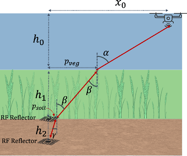
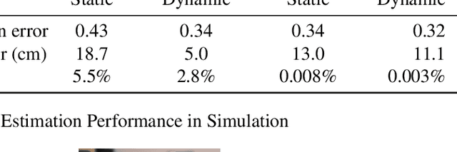

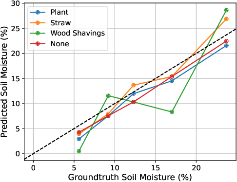
Soil moisture sensing through biomass or vegetation canopy has challenged researchers, even those who use SAR sensors with penetration capabilities. This is mainly due to the imposed extra time and phase offsets on Radio Frequency (RF) signals as they travel through the canopy. These offsets depend on the vegetation canopy moisture and height, both of which are typically unknown in agricultural and forest fields. In this paper, we leverage the mobility of an unmanned aerial system (UAS) to collect spatially-diverse radar measurements, enabling the joint estimation of soil moisture, above-ground biomass moisture, and biomass height, all without assuming any calibration steps. We leverage the changes in time-of-flight (ToF) and angle-of-arrival (AoA) measurements of reflected radar signals as the UAS flies above a reflector buried under the soil. We demonstrate the effectiveness of our algorithm by simulating its performance under realistic measurement noises as well as conducting lab experiments with different types of above-ground biomass. Our simulation results conclude that our algorithm is capable of estimating volumetric soil moisture to less than 1% median absolute error (MAE), vegetation height to 11.1cm MAE, and vegetation relative permittivity to 0.32 MAE. Our experimental results demonstrate the effectiveness of the proposed method in practical scenarios for varying biomass moistures and heights.
Dual-Frequency Radar Wave-Inversion for Sub-Surface Material Characterization
Mar 28, 2024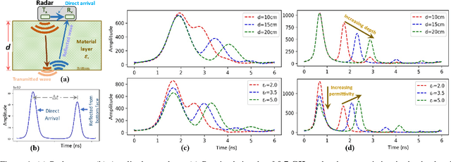
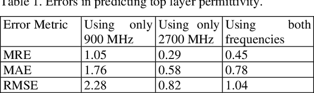
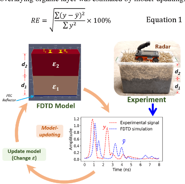
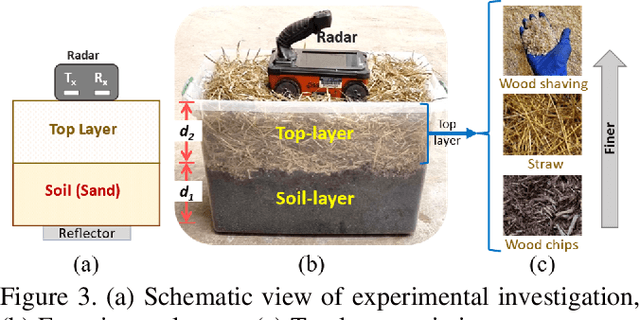
Moisture estimation of sub-surface soil and the overlaying biomass layer is pivotal in precision agriculture and wildfire risk assessment. However, the characterization of layered material is nontrivial due to the radar penetration-resolution tradeoff. Here, a waveform inversion-based method was proposed for predicting the dielectric permittivity (as a moisture proxy) of the bottom soil layer and the top biomass layer from radar signals. Specifically, the use of a combination of a higher and a lower frequency radar compared to a single frequency in predicting the permittivity of both the soil and the overlaying layer was investigated in this study. The results show that each layer was best characterized via one of the frequencies. However, for the simultaneous prediction of both layers permittivity, the most consistent results were achieved by inversion of data from a combination of both frequencies, showing better correlation with in situ permittivity and reduced prediction errors.
Bayesian inversion of GPR waveforms for uncertainty-aware sub-surface material characterization
Dec 13, 2023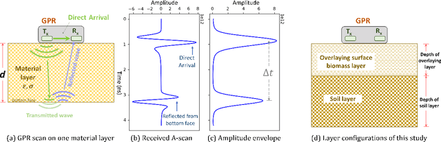
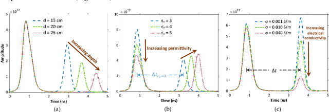
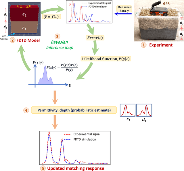
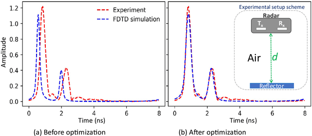
Accurate estimation of sub-surface properties like moisture content and depth of layers is crucial for applications spanning sub-surface condition monitoring, precision agriculture, and effective wildfire risk assessment. Soil in nature is often covered by overlaying surface material, making its characterization using conventional methods challenging. In addition, the estimation of the properties of the overlaying layer is crucial for applications like wildfire assessment. This study thus proposes a Bayesian model-updating-based approach for ground penetrating radar (GPR) waveform inversion to predict sub-surface properties like the moisture contents and depths of the soil layer and overlaying material accumulated above the soil. The dielectric permittivity of material layers were predicted with the proposed method, along with other parameters, including depth and electrical conductivity of layers. The proposed Bayesian model updating approach yields probabilistic estimates of these parameters that can provide information about the confidence and uncertainty related to the estimates. The methodology was evaluated for a diverse range of experimental data collected through laboratory and field investigations. Laboratory investigations included variations in soil moisture values and depth of the top layer (or overlaying material), and the field investigation included measurement of field soil moisture for sixteen days. The results demonstrated predictions consistent with time-domain reflectometry (TDR) measurements and conventional gravimetric tests. The top layer depth could also be predicted with reasonable accuracy. The proposed method provides a promising approach for uncertainty-aware sub-surface parameter estimation that can enable decision-making for risk assessment across a wide range of applications.