 Add to Chrome
 Add to Firefox
 Add to Edge
G-DRAGON: Geospatial Reasoning and Dynamic Planning for Retrieval-Augmented Outdoor Navigation
May 25, 2026
Autonomous ground robots operating in large-scale outdoor environments require both robust long-range navigation and fine-grained ''last-mile'' exploration. Current advances in visual-language navigation (VLN) work well at short-range tasks, lacking geospatial grounding for long-distance missions. Some OpenStreetMap (OSM)-based methods relying on cloud-based Large Language Models (LLMs) are prone to factual hallucination and cannot conduct ''last-mile'' exploration based on human instruction. To address these challenges, we present G-DRAGON, a retrieval-augmented framework for outdoor, open-world navigation. This framework maps natural-language commands to versioned, local OSM entities via generative retrieval based on lightweight LLM, yielding accurate coordinates for global route planning. A high-level planning module bridges global topological routes with the SLAM system, projecting geospatial waypoints into the robot's navigable frame. For the ''last mile," the framework transitions to frontier-based exploration and open-set semantic voxel mapping to localize open-vocabulary targets. Experimental results in simulation demonstrate our framework outperforms state-of-the-art baselines. Furthermore, we validate the system in unseen real-world urban environments on an Unmanned Ground Vehicle (UGV), successfully completing person-search missions with trajectories of up to 500m.

BRIGHT-VO: Brightness-Guided Hybrid Transformer for Visual Odometry with Multi-modality Refinement Module
Jan 16, 2025
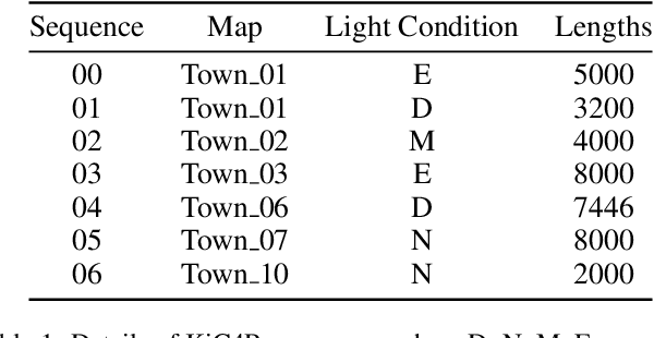
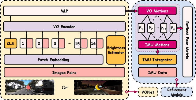
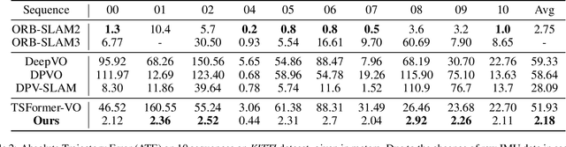
Visual odometry (VO) plays a crucial role in autonomous driving, robotic navigation, and other related tasks by estimating the position and orientation of a camera based on visual input. Significant progress has been made in data-driven VO methods, particularly those leveraging deep learning techniques to extract image features and estimate camera poses. However, these methods often struggle in low-light conditions because of the reduced visibility of features and the increased difficulty of matching keypoints. To address this limitation, we introduce BrightVO, a novel VO model based on Transformer architecture, which not only performs front-end visual feature extraction, but also incorporates a multi-modality refinement module in the back-end that integrates Inertial Measurement Unit (IMU) data. Using pose graph optimization, this module iteratively refines pose estimates to reduce errors and improve both accuracy and robustness. Furthermore, we create a synthetic low-light dataset, KiC4R, which includes a variety of lighting conditions to facilitate the training and evaluation of VO frameworks in challenging environments. Experimental results demonstrate that BrightVO achieves state-of-the-art performance on both the KiC4R dataset and the KITTI benchmarks. Specifically, it provides an average improvement of 20% in pose estimation accuracy in normal outdoor environments and 259% in low-light conditions, outperforming existing methods. For widespread use and further development, the research work is fully open-source at https://github.com/Anastasiawd/BrightVO.