 Add to Chrome
 Add to Firefox
 Add to Edge
TESSERA v2: Scaling Pixel-wise Earth Foundation Models
Jul 04, 2026
Pixel-wise Earth-observation (EO) foundation models are now achieving state-of-the-art performance via generated spatial embeddings. However, how these models scale and how best to spend a pretraining budget remain poorly understood. We present the largest controlled scaling study for EO to date: 395 training runs on 1,024 GH200 superchips within a fixed pixel-wise Barlow Twins family, each evaluated on 15 downstream tasks. We find that pretraining loss barely predicts downstream performance (|Pearson r| < 0.2), so selecting models by loss wastes a large share of the compute. We also find that, as the training budget grows, the encoder and the data should grow together while the projector stays fixed, which gives a simple rule for allocating compute. Using this rule, we train a family of pixel-wise models (0.5B and 1B, with a 2B model in training) and distill them into compact students for embeddings-as-data deployment. The 21-million-parameter distilled TESSERA v2-1B-M in aggregate outperforms all open and proprietary models tested, some of which are orders of magnitude larger. These students produce Matryoshka representations that are inexpensive to serve: a 16-dimensional prefix keeps 92% of the full 128-dimensional performance at 1/8 of the storage. Upon completion of training we plan to release v2 global embeddings covering 2017-2025. Together, these results give a concrete, empirically grounded recipe for scaling pixel-wise EO foundation models: train large encoders, select by downstream performance, and distil into flexible student models. All code will be released at https://github.com/ucam-eo/tessera.

Exploring the potential of AlphaEarth and TESSERA embeddings for Fine-scale Local Climate Zone Mapping: A case study across five cities in Switzerland
Jun 18, 2026Understanding urban spatial morphology is critical for climate modeling, risk assessment, and sustainable urban design, and Local Climate Zone (LCZ) mapping provides the basic framework for this. However, many cities still use coarse ~100-m resolution LCZ records, which are unsuitable for fine-scale urban research. In this study, precomputed embeddings from TESSERA (Feng et al., 2025) and AlphaEarth (Brown et al., 2025) are compared to traditional Sentinel-1/2 (S1S2) composites in five Swiss cities to see if they can upscale coarse LCZ maps to 10-m resolution using an attention-based U-Net. Three experiments assess multi-city transferability, the impact of higher-resolution reference data, and temporal robustness to year-to-year phenology changes. We find that all datasets achieve strong performance with test data Intersection-over-Union (IoU) ranging from 0.59-0.69 and 0.77-0.82 in the first two experiments. TESSERA consistently outperforms both S1S2 and AlphaEarth across both settings As expected, we find that the transfer of embedding-based models from one year to another remains an open challenge. Overall, however, our results demonstrate the promising potential of embeddings derived from EO foundation models to reduce time consuming preprocessing, respectively, manual feature engineering tasks and to guide a universal deep learning-based LCZ mapping workflow. When combined with a simple location-aware attention U-Net architecture, the embeddings enhance regional transferability and scalability, supporting the development of comprehensive and reproducible fine-scale LCZ maps for global urban climate applications Improving reference data quality remains the strongest lever for further accuracy gains.
Embedding -based Crop Type Classification in the Groundnut Basin of Senegal
Jan 23, 2026Crop type maps from satellite remote sensing are important tools for food security, local livelihood support and climate change mitigation in smallholder regions of the world, but most satellite-based methods are not well suited to smallholder conditions. To address this gap, we establish a four-part criteria for a useful embedding-based approach consisting of 1) performance, 2) plausibility, 3) transferability and 4) accessibility and evaluate geospatial foundation model (FM) embeddings -based approaches using TESSERA and AlphaEarth against current baseline methods for a region in the groundnut basin of Senegal. We find that the TESSERA -based approach to land cover and crop type mapping fulfills the selection criteria best, and in one temporal transfer example shows 28% higher accuracy compared to the next best method. These results indicate that TESSERA embeddings are an effective approach for crop type classification and mapping tasks in Senegal.
MAGIC: Modular Auto-encoder for Generalisable Model Inversion with Bias Corrections
May 29, 2024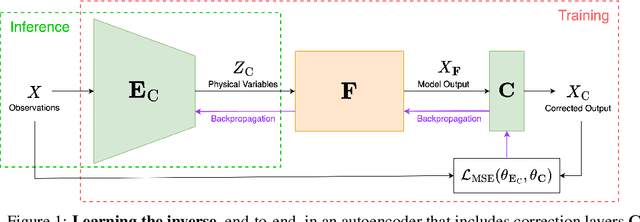


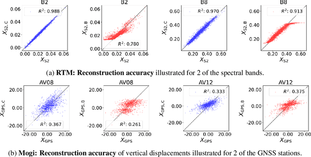
Scientists often model physical processes to understand the natural world and uncover the causation behind observations. Due to unavoidable simplification, discrepancies often arise between model predictions and actual observations, in the form of systematic biases, whose impact varies with model completeness. Classical model inversion methods such as Bayesian inference or regressive neural networks tend either to overlook biases or make assumptions about their nature during data preprocessing, potentially leading to implausible results. Inspired by recent work in inverse graphics, we replace the decoder stage of a standard autoencoder with a physical model followed by a bias-correction layer. This generalisable approach simultaneously inverts the model and corrects its biases in an end-to-end manner without making strong assumptions about the nature of the biases. We demonstrate the effectiveness of our approach using two physical models from disparate domains: a complex radiative transfer model from remote sensing; and a volcanic deformation model from geodesy. Our method matches or surpasses results from classical approaches without requiring biases to be explicitly filtered out, suggesting an effective pathway for understanding the causation of various physical processes.
From Spectra to Biophysical Insights: End-to-End Learning with a Biased Radiative Transfer Model
Mar 05, 2024
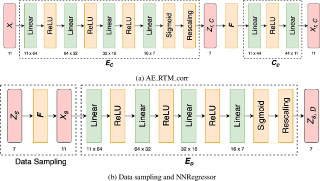

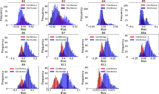
Advances in machine learning have boosted the use of Earth observation data for climate change research. Yet, the interpretability of machine-learned representations remains a challenge, particularly in understanding forests' biophysical reactions to climate change. Traditional methods in remote sensing that invert radiative transfer models (RTMs) to retrieve biophysical variables from spectral data often fail to account for biases inherent in the RTM, especially for complex forests. We propose to integrate RTMs into an auto-encoder architecture, creating an end-to-end learning approach. Our method not only corrects biases in RTMs but also outperforms traditional techniques for variable retrieval like neural network regression. Furthermore, our framework has potential generally for inverting biased physical models. The code is available on https://github.com/yihshe/ai-refined-rtm.git.
A mixed model approach to drought prediction using artificial neural networks: Case of an operational drought monitoring environment
Jan 10, 2019


Droughts, with their increasing frequency of occurrence, continue to negatively affect livelihoods and elements at risk. For example, the 2011 in drought in east Africa has caused massive losses document to have cost the Kenyan economy over $12bn. With the foregoing, the demand for ex-ante drought monitoring systems is ever-increasing. The study uses 10 precipitation and vegetation variables that are lagged over 1, 2 and 3-month time-steps to predict drought situations. In the model space search for the most predictive artificial neural network (ANN) model, as opposed to the traditional greedy search for the most predictive variables, we use the General Additive Model (GAM) approach. Together with a set of assumptions, we thereby reduce the cardinality of the space of models. Even though we build a total of 102 GAM models, only 21 have R2 greater than 0.7 and are thus subjected to the ANN process. The ANN process itself uses the brute-force approach that automatically partitions the training data into 10 sub-samples, builds the ANN models in these samples and evaluates their performance using multiple metrics. The results show the superiority of 1-month lag of the variables as compared to longer time lags of 2 and 3 months. The champion ANN model recorded an R2 of 0.78 in model testing using the out-of-sample data. This illustrates its ability to be a good predictor of drought situations 1-month ahead. Investigated as a classifier, the champion has a modest accuracy of 66% and a multi-class area under the ROC curve (AUROC) of 89.99%