 Add to Chrome
 Add to Firefox
 Add to Edge
Towards Real-Time and Adaptable LiDAR Scene Completion
Aug 17, 2026
LiDAR scene completion is a key component of 3D perception in autonomous driving, where the scene must be completed in real time to be usable in downstream tasks. Existing approaches typically follow an initialize-and-refine paradigm, in which a coarse initialization of the scene is first constructed, then refined into complete 3D geometry. Generative models are slower because they iteratively refine random Gaussian noise into the scene, while non-generative methods perturb the partial scene with a fixed noise scale, which limits coverage of large gaps and occluded regions and requires manual recalibration for each new sensor configuration. We present RapidLiDAR, a LiDAR scene completion method that treats the initialization itself as a learned, data-driven component. We propose an adaptive initialization module that predicts a spatially varying displacement for each partial input point, expanding the partial observations into a coarse scene initialization adapted to the local geometry, without requiring manual noise tuning. To refine this coarse initialization into a complete and coherent scene, we additionally propose a multi-scale reconstruction module that further refines point positions by querying multi-scale 3D voxel and 2D BEV feature maps constructed from the input scan. By replacing point-neighborhood operators such as farthest point sampling and $k$-nearest neighbor search with voxel- and BEV-based feature extraction, our architecture is faster and can handle different input resolutions by design. Experiments on SemanticKITTI and KITTI-360 show that our method achieves completion performance on par with the state of the art while completing a full scene in 0.1 seconds, which is 2.3 times faster than the fastest prior method. This matches the 10 Hz acquisition rate of typical automotive LiDAR sensors, taking a step toward real-time LiDAR scene completion.

Point Cloud Upsampling through Patch-based Frequency Superposition
Jun 12, 2026In recent years, neural networks have become the dominant models in most point cloud upsampling methods. Although these approaches are achieving good results, they do have drawbacks, such as a lack of interpretability and data dependency. Moreover, they have to be trained on a dataset that is similar to the test data in order to perform well. To avoid these disadvantages, we propose Point Cloud Upsampling through Patch-based Frequency Superposition (PUtPFS), an optimization-based approach that selects subsets of points and estimates the surface of this set through superpositioning spatial frequencies. Then, new points are placed on this surface. By successively selecting points in the least dense regions of the point cloud, a uniform upsampling can be reached. With this method, we surpass the current best upsampling results in the commonly considered point-to-surface distance. Furthermore, we achieve the best Chamfer and Hausdorff distance among the optimization-based approaches. As an additional advantage, our method does not need any training data and is mathematically interpretable.
I2PRef: Image-Driven Point Completion with Iterative Refinement
May 26, 2026We present an image-conditioned point cloud completion approach that treats images as the primary geometric source rather than a secondary guide. To this end, we introduce an Image-to-Point (I2P) module that can reconstruct complete point clouds directly from a single RGB image, with no need for 3D inputs. Additionally, we introduce a transformer-based Point-to-Point (P2P) refinement module that uses self- and cross-attention between point tokens and image features to iteratively refine the coarse I2P output. The I2P module enables the image encoder to learn rich geometric representations, while the P2P module progressively recovers fine-grained details. Unlike existing multimodal methods that rely on auxiliary losses or fusion modules, our explicit I2P task provides a strong, geometry-aware prior based on images alone. Extensive experiments on ShapeNet-ViPC demonstrate state-of-the-art completion performance with a 12.3% relative Chamfer Distance improvement over prior methods. Code is available at: https://github.com/AzharSindhi/I2PRef.git
Gesture Classification in Artworks Using Contextual Image Features
Dec 04, 2024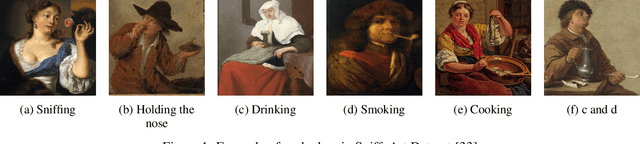
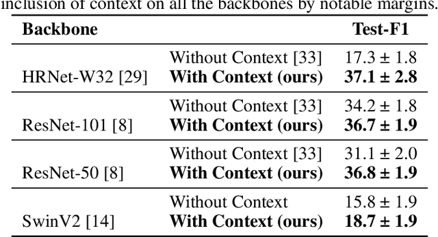
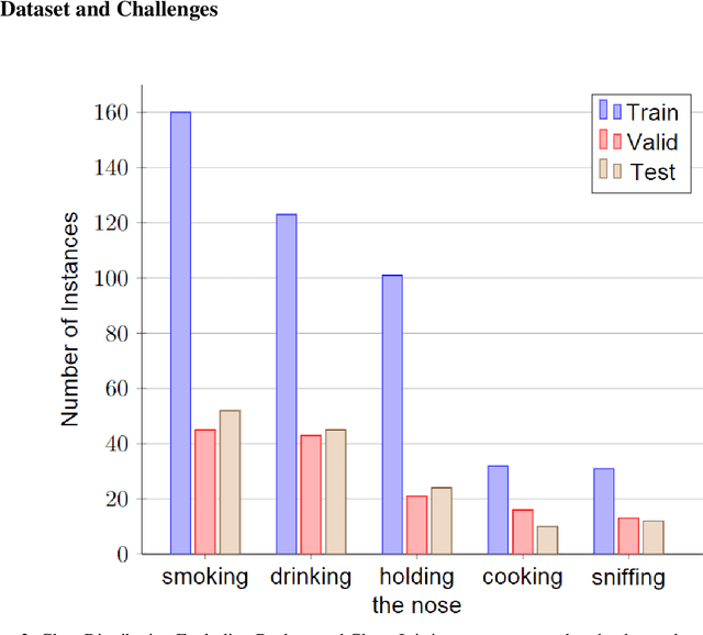
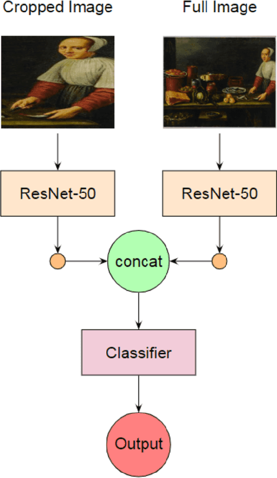
Recognizing gestures in artworks can add a valuable dimension to art understanding and help to acknowledge the role of the sense of smell in cultural heritage. We propose a method to recognize smell gestures in historical artworks. We show that combining local features with global image context improves classification performance notably on different backbones.
SniffyArt: The Dataset of Smelling Persons
Nov 20, 2023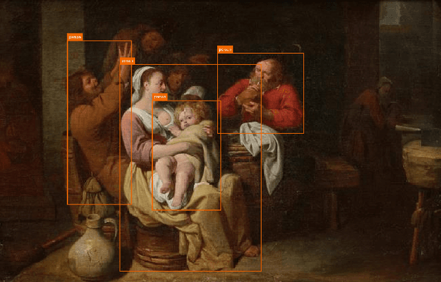
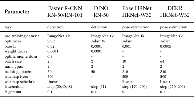
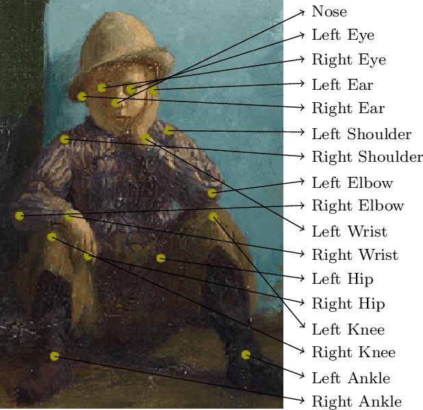

Smell gestures play a crucial role in the investigation of past smells in the visual arts yet their automated recognition poses significant challenges. This paper introduces the SniffyArt dataset, consisting of 1941 individuals represented in 441 historical artworks. Each person is annotated with a tightly fitting bounding box, 17 pose keypoints, and a gesture label. By integrating these annotations, the dataset enables the development of hybrid classification approaches for smell gesture recognition. The datasets high-quality human pose estimation keypoints are achieved through the merging of five separate sets of keypoint annotations per person. The paper also presents a baseline analysis, evaluating the performance of representative algorithms for detection, keypoint estimation, and classification tasks, showcasing the potential of combining keypoint estimation with smell gesture classification. The SniffyArt dataset lays a solid foundation for future research and the exploration of multi-task approaches leveraging pose keypoints and person boxes to advance human gesture and olfactory dimension analysis in historical artworks.
* 10 pages, 8 figures