 Add to Chrome
 Add to Firefox
 Add to Edge
Mapping Pamir: Multi-Session Visual-Inertial SLAM and 3D Reconstruction of an Underwater Shipwreck
Jul 12, 2026
This paper presents a framework for multi-session mapping of underwater environments utilizing an affordable action camera. The Visual-Inertial data are augmented by water depth recordings from a dive computer. SVIn2, an open-source VI-SLAM framework, is utilized to generate a trajectory and a sparse reconstruction for each session. Utilizing the keyframes extracted from SVIn2 and the estimated camera poses, a Structure-from-Motion (SfM) framework, COLMAP, is employed for global optimization and to produce a dense reconstruction of the target environment. The presence of calibration targets at fixed locations, when available, is used to estimate the coordinate transformation between different data collection sessions, thus transforming the different sessions into the same coordinate frame. The proposed pipeline is employed for the mapping of a shipwreck off the coast of Barbados. For the first time, both the exterior and the accessible interior parts of the wreck were mapped in two sessions, while a third session employed two cameras with different fields of view.

Manipulider: A Multi-Engine Buoyancy-Controlled Robot for Thrusterless Underwater Gliding and Manipulation
Jun 19, 2026The Manipulider is a buoyancy-actuated underwater robot that enables thrusterless, glide-like locomotion and attitude-based manipulation, while providing a magnetic modular interface for rapid payload swapping (e.g., a gripper or sensors). Four syringe-based buoyancy engines distributed around the body jointly regulate net buoyancy and the center of buoyancy, allowing the vehicle to maintain large tilt angles through static force balance without continuous thrust and to avoid propeller entanglement risks. We present the mechanical and electrical design, calibration procedure, and control architecture. Experiments with a gripper attached (no external payload) show a controllable buoyancy-displacement range of 40 mL per engine ({\approx}160 g total buoyancy authority), maximum statically stable tilts of 64.6° (single-engine) and 61.8° (dual-engine), and representative vertical and tilt-transition dynamics. We further demonstrate tilt regulation, controlled ascent/descent primitives, and a proof-of-concept gripper-based payload-transport sequence without thrusters.
4th Workshop on Maritime Computer Vision (MaCVi): Challenge Overview
Apr 14, 2026The 4th Workshop on Maritime Computer Vision (MaCVi) is organized as part of CVPR 2026. This edition features five benchmark challenges with emphasis on both predictive accuracy and embedded real-time feasibility. This report summarizes the MaCVi 2026 challenge setup, evaluation protocols, datasets, and benchmark tracks, and presents quantitative results, qualitative comparisons, and cross-challenge analyses of emerging method trends. We also include technical reports from top-performing teams to highlight practical design choices and lessons learned across the benchmark suite. Datasets, leaderboards, and challenge resources are available at https://macvi.org/workshop/cvpr26.
Variable-Resolution Virtual Maps for Autonomous Exploration with Unmanned Surface Vehicles (USVs)
Mar 24, 2026Autonomous exploration by unmanned surface vehicles (USVs) in near-shore waters requires reliable localisation and consistent mapping over extended areas, but this is challenged by GNSS degradation, environment-induced localisation uncertainty, and limited on-board computation. Virtual map-based methods explicitly model localisation and mapping uncertainty by tightly coupling factor-graph SLAM with a map uncertainty criterion. However, their storage and computational costs scale poorly with fixed-resolution workspace discretisations, leading to inefficiency in large near-shore environments. Moreover, overvaluing feature-sparse open-water regions can increase the risk of SLAM failure as a result of imbalance between exploration and exploitation. To address these limitations, we propose a Variable-Resolution Virtual Map (VRVM), a computationally efficient method for representing map uncertainty using bivariate Gaussian virtual landmarks placed in the cells of an adaptive quadtree. The adaptive quadtree enables an area-weighted uncertainty representation that keeps coarse, far-field virtual landmarks deliberately uncertain while allocating higher resolution to information-dense regions, and reduces the sensitivity of the map valuation to local refinements of the tree. An expectation-maximisation (EM) planner is adopted to evaluate pose and map uncertainty along frontiers using the VRVM, balancing exploration and exploitation. We evaluate VRVM against several state-of-the-art exploration algorithms in the VRX Gazebo simulator, using a realistic marina environment across different testing scenarios with an increasing level of exploration difficulty. The results indicate that our method offers safer behaviour and better utilisation of on-board computation in GNSS-degraded near-shore environments.
RENEW: Risk- and Energy-Aware Navigation in Dynamic Waterways
Jan 23, 2026We present RENEW, a global path planner for Autonomous Surface Vehicle (ASV) in dynamic environments with external disturbances (e.g., water currents). RENEW introduces a unified risk- and energy-aware strategy that ensures safety by dynamically identifying non-navigable regions and enforcing adaptive safety constraints. Inspired by maritime contingency planning, it employs a best-effort strategy to maintain control under adverse conditions. The hierarchical architecture combines high-level constrained triangulation for topological diversity with low-level trajectory optimization within safe corridors. Validated with real-world ocean data, RENEW is the first framework to jointly address adaptive non-navigability and topological path diversity for robust maritime navigation.
Underwater Dense Mapping with the First Compact 3D Sonar
Oct 21, 2025In the past decade, the adoption of compact 3D range sensors, such as LiDARs, has driven the developments of robust state-estimation pipelines, making them a standard sensor for aerial, ground, and space autonomy. Unfortunately, poor propagation of electromagnetic waves underwater, has limited the visibility-independent sensing options of underwater state-estimation to acoustic range sensors, which provide 2D information including, at-best, spatially ambiguous information. This paper, to the best of our knowledge, is the first study examining the performance, capacity, and opportunities arising from the recent introduction of the first compact 3D sonar. Towards that purpose, we introduce calibration procedures for extracting the extrinsics between the 3D sonar and a camera and we provide a study on acoustic response in different surfaces and materials. Moreover, we provide novel mapping and SLAM pipelines tested in deployments in underwater cave systems and other geometrically and acoustically challenging underwater environments. Our assessment showcases the unique capacity of 3D sonars to capture consistent spatial information allowing for detailed reconstructions and localization in datasets expanding to hundreds of meters. At the same time it highlights remaining challenges related to acoustic propagation, as found also in other acoustic sensors. Datasets collected for our evaluations would be released and shared with the community to enable further research advancements.
Mapping the Catacombs: An Underwater Cave Segment of the Devil's Eye System
Jul 08, 2025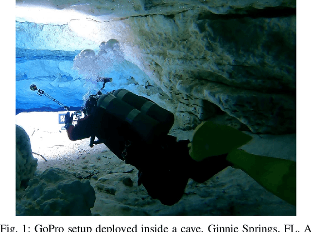
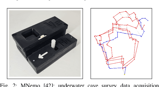
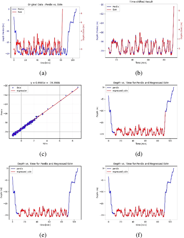
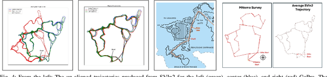
This paper presents a framework for mapping underwater caves. Underwater caves are crucial for fresh water resource management, underwater archaeology, and hydrogeology. Mapping the cave's outline and dimensions, as well as creating photorealistic 3D maps, is critical for enabling a better understanding of this underwater domain. In this paper, we present the mapping of an underwater cave segment (the catacombs) of the Devil's Eye cave system at Ginnie Springs, FL. We utilized a set of inexpensive action cameras in conjunction with a dive computer to estimate the trajectories of the cameras together with a sparse point cloud. The resulting reconstructions are utilized to produce a one-dimensional retract of the cave passages in the form of the average trajectory together with the boundaries (top, bottom, left, and right). The use of the dive computer enables the observability of the z-dimension in addition to the roll and pitch in a visual/inertial framework (SVIn2). In addition, the keyframes generated by SVIn2 together with the estimated camera poses for select areas are used as input to a global optimization (bundle adjustment) framework -- COLMAP -- in order to produce a dense reconstruction of those areas. The same cave segment is manually surveyed using the MNemo V2 instrument, providing an additional set of measurements validating the proposed approach. It is worth noting that with the use of action cameras, the primary components of a cave map can be constructed. Furthermore, with the utilization of a global optimization framework guided by the results of VI-SLAM package SVIn2, photorealistic dense 3D representations of selected areas can be reconstructed.
Multi-Object Active Search and Tracking by Multiple Agents in Untrusted, Dynamically Changing Environments
Feb 03, 2025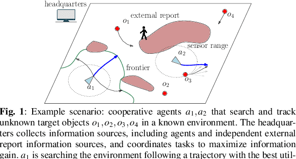
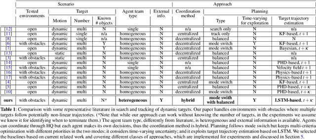
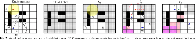
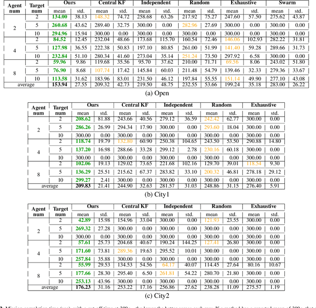
This paper addresses the problem of both actively searching and tracking multiple unknown dynamic objects in a known environment with multiple cooperative autonomous agents with partial observability. The tracking of a target ends when the uncertainty is below a threshold. Current methods typically assume homogeneous agents without access to external information and utilize short-horizon target predictive models. Such assumptions limit real-world applications. We propose a fully integrated pipeline where the main contributions are: (1) a time-varying weighted belief representation capable of handling knowledge that changes over time, which includes external reports of varying levels of trustworthiness in addition to the agents; (2) the integration of a Long Short Term Memory-based trajectory prediction within the optimization framework for long-horizon decision-making, which reasons in time-configuration space, thus increasing responsiveness; and (3) a comprehensive system that accounts for multiple agents and enables information-driven optimization. When communication is available, our strategy consolidates exploration results collected asynchronously by agents and external sources into a headquarters, who can allocate each agent to maximize the overall team's utility, using all available information. We tested our approach extensively in simulations against baselines, and in robustness and ablation studies. In addition, we performed experiments in a 3D physics based engine robot simulator to test the applicability in the real world, as well as with real-world trajectories obtained from an oceanography computational fluid dynamics simulator. Results show the effectiveness of our method, which achieves mission completion times 1.3 to 3.2 times faster in finding all targets, even under the most challenging scenarios where the number of targets is 5 times greater than that of the agents.
An Untethered Bioinspired Robotic Tensegrity Dolphin with Multi-Flexibility Design for Aquatic Locomotion
Nov 01, 2024

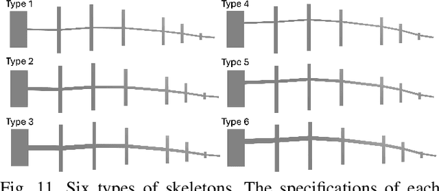

This paper presents the first steps toward a soft dolphin robot using a bio-inspired approach to mimic dolphin flexibility. The current dolphin robot uses a minimalist approach, with only two actuated cable-driven degrees of freedom actuated by a pair of motors. The actuated tail moves up and down in a swimming motion, but this first proof of concept does not permit controlled turns of the robot. While existing robotic dolphins typically use revolute joints to articulate rigid bodies, our design -- which will be made opensource -- incorporates a flexible tail with tunable silicone skin and actuation flexibility via a cable-driven system, which mimics muscle dynamics and design flexibility with a tunable skeleton structure. The design is also tunable since the backbone can be easily printed in various geometries. The paper provides insights into how a few such variations affect robot motion and efficiency, measured by speed and cost of transport (COT). This approach demonstrates the potential of achieving dolphin-like motion through enhanced flexibility in bio-inspired robotics.
Active Learning-augmented Intention-aware Obstacle Avoidance of Autonomous Surface Vehicles in High-traffic Waters
Nov 01, 2024
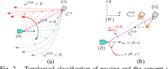


This paper enhances the obstacle avoidance of Autonomous Surface Vehicles (ASVs) for safe navigation in high-traffic waters with an active state estimation of obstacle's passing intention and reducing its uncertainty. We introduce a topological modeling of passing intention of obstacles, which can be applied to varying encounter situations based on the inherent embedding of topological concepts in COLREGs. With a Long Short-Term Memory (LSTM) neural network, we classify the passing intention of obstacles. Then, for determining the ASV maneuver, we propose a multi-objective optimization framework including information gain about the passing obstacle intention and safety. We validate the proposed approach under extensive Monte Carlo simulations (2,400 runs) with a varying number of obstacles, dynamic properties, encounter situations, and different behavioral patterns of obstacles (cooperative, non-cooperative). We also present the results from a real marine accident case study as well as real-world experiments of a real ASV with environmental disturbances, showing successful collision avoidance with our strategy in real-time.