 Add to Chrome
 Add to Firefox
 Add to Edge
Dual-Branch State-Displacement Network for Sea Surface Temperature Super-Resolution
Aug 15, 2026
Sea surface temperature (SST) is a critical indicator of global climate change, yet satellite-derived SST imagery often suffers from coarse spatial resolution, limiting the ability to capture fine-scale thermal structures such as ocean fronts. To address this, we propose a Dual-Branch State-Displacement Network (DBSD-Net) for SST super-resolution. DBSD-Net adopts a dual-branch architecture: a wavelet frequency branch that explicitly separates low and high-frequency components via discrete wavelet transform for targeted processing, and a VGGUNet branch that extracts multi-scale semantic features from a frozen pre-trained VGG backbone. Within the wavelet branch, we introduce a Structural State Space Module (SSSM) with a Gated Structure Refinement (GSR) unit to efficiently capture long-range dependencies and enhance structural integrity, and a Displacement Gate Module (DGM) that learns a displacement field for geometry-aware modulation of high-frequency details, thereby mitigating spatially varying degradation. Experiments on multiple public SST datasets demonstrate that DBSD-Net outperforms existing state-of-the-art methods.

Arctic Sea Ice Image Super-Resolution Based on Multi-Scale Convolution and Dual-Gating Mechanism
Jun 03, 2024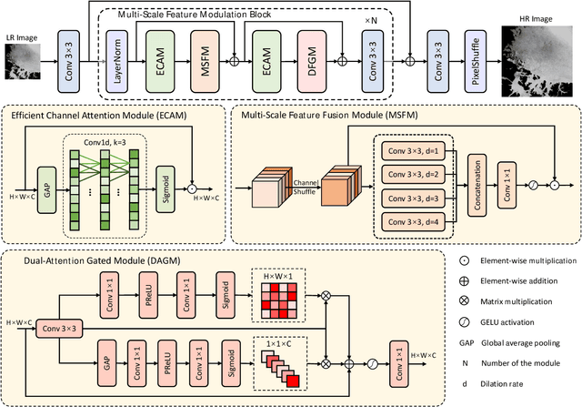
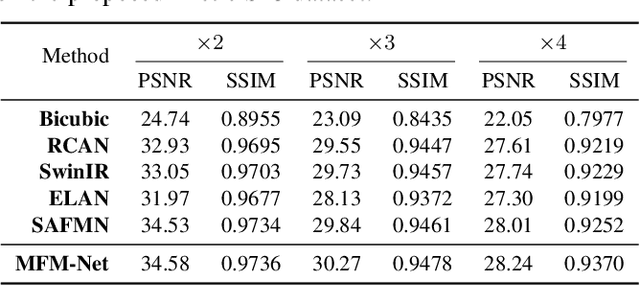
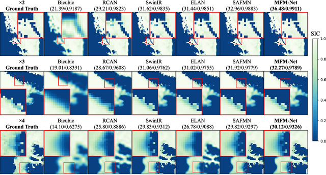
Arctic Sea Ice Concentration (SIC) is the ratio of ice-covered area to the total sea area of the Arctic Ocean, which is a key indicator for maritime activities. Nowadays, we often use passive microwave images to display SIC, but it has low spatial resolution, and most of the existing super-resolution methods of Arctic SIC don't take the integration of spatial and channel features into account and can't effectively integrate the multi-scale feature. To overcome the aforementioned issues, we propose MFM-Net for Arctic SIC super-resolution, which concurrently aggregates multi-scale information while integrating spatial and channel features. Extensive experiments on Arctic SIC dataset from the AMSR-E/AMSR-2 SIC DT-ASI products from Ocean University of China validate the effectiveness of porposed MFM-Net.